
Fires, a hazard of the industrial revolution, often caused uninsured property owners to suffer great financial loss. To protect against such calamity, fire insurance companies sprang up all over the U.S. Policy writers, however, could not always inspect properties in person. In 1866, D. A. Sanborn, an enterprising surveyor in Massachusetts, began creating specialized maps to help under-writers evaluate the risks.
The Kansas City Sanborn Fire Insurance maps in the Missouri Valley Special Collections Digital Gallery consist of over 1600 individual pages or images, taken from 19 bound physical volumes. These maps show a detailed, street-level history of the development of our town for over half a century, from 1895 to 1957.
Details on the Sanborn Maps include building footprints and numbers (addresses), street names and elevations, construction material, number of stories, and items like hydrants, fire alarms, and water mains. The locations of underground gasoline or oil tanks and water pipes are also indicated. The maps show rivers, railroad tracks, bridges, and types of buildings, such as greenhouses, theaters, stables, etc. They identify businesses, schools, churches, hospitals, and other buildings by name.
Over the years, surveyors with the company created maps for more than 12,000 American cities and towns. Sanborn’s company eventually became known simply as Sanborn and today specializes in geographic information systems.
The large-scale maps provide an invaluable resource for historians, genealogists, geographers, students, environmentalists, and others researching buildings, neighborhoods, and the individuals that lived and worked in them.
By combining the maps with other resources in the Missouri Valley Room, like city directories, the Digital Gallery of images, and the newspaper clipping index, you can:
- Research the history of a building and surrounding area
- Learn little-known facts regarding a residence, school, church, park, business, and more
- Trace neighborhood change and development
- Provide clues for renovating a building
- Make your ancestors come alive by tracing the route they would walk to school, a business, or church
And much more!
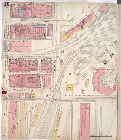
The above map depicts the northwestern part of early Kansas City in West Bottoms from Union Avenue south to W. 12th Street and from Mulberry Street east to Santa Fe Street, showing buildings, streets, and railroad lines. Note the roundhouse on the right hand side of the map. The defining feature of the traditional roundhouse was the turntable, which provides access when the building is used for repair facilities or for storage of steam locomotives.
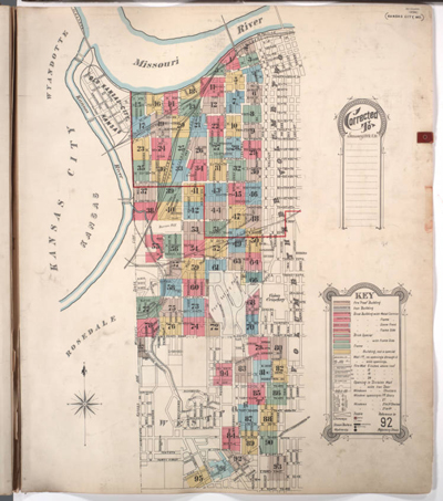
Key to Sanborn Map of Kansas City, Vol. 1 showing the Kansas City area bounded from the Kansas and Missouri State Line on the west, Cherry on the east, the Missouri River to the north, and East 43rd to the south. Also shows railroads, bridges, parks, and a cemetery. The key on the bottom right hand side shows how structures were shown for insurance purposes.