Askren Photograph Collection
-

-
Title
-
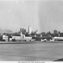
Municipal Airport
-
Description
-
View of the terminal building at Municipal Airport, looking toward the southeast with the Kansas City skyline in the background. There are TWA airplanes on the ground and the Transcontinental & Western Air, Inc. (TWA) airport hanger building is in view.
-
Date
-
1939
-
Object Type
-
Photograph
-
-
Title
-
Municipal Airport
-
Description
-
View from west side of runway looking at terminal building and Transcontinental & Western Air, Inc. hangar with two planes. Kansas City downtown skyline in background.
-
Object Type
-
Photograph
-

-
Title
-
Municipal Airport Airplane Christening Ceremony
-
Description
-
Three individuals stand on a platform to christen a tri-motor airplane, "The Kansas City," at a Municipal Airport terminal building groundbreaking. The individuals include Eleanor Beach, daughter of Kansas City Mayor Albert I. Beach, and City Manager Henry McElroy.
-
Date
-
1929-06-26
-
Object Type
-
Negative
-

-
Title
-
The Spirit of St. Louis Airplane
-
Description
-
View of the Charles Lindbergh plane, the Spirit of St. Louis, on the ground at Kansas City's Municipal Airport.
-
Date
-
1927
-
Object Type
-
Photograph
-

-
Title
-
Aerial View of Downtown Kansas City
-
Description
-
Aerial view looking northwest from about 16th Street, from Quality Hill to Locust Street. The Missouri River and Municipal Airport are visible as well as the Broadway Bridge, 2nd Hannibal Bridge, and the Paseo Bridge.
-
Date
-
1962-11-21
-
Object Type
-
Photograph
-

-
Title
-
Aerial View of Downtown Kansas City
-
Description
-
Aerial view of downtown Kansas City and portions of North Kansas City, Missouri, looking toward the northwest. The Municipal Airport is in view as well as the Missouri River as it bends to the north. The Broadway Bridge, 2nd Hannibal Bridge, and the ASB Bridge, in that order from left to right, can be seen spanning the river. No print image; negative and digital only.
-
Date
-
1962-11-20
-
Object Type
-
Negative
-

-
Title
-
Aerial View of Municipal Airport
-
Description
-
View of Municipal Airport and portions of North Kansas City, Missouri, looking north. No print image; negative and digital only.
-
Object Type
-
Negative
-

-
Title
-
Municipal Airport
-
Description
-
View of Municipal Airport Terminal, looking toward the west. Includes parking lot and cars.
-
Date
-
1939
-
Object Type
-
Negative
-

-
Title
-
Municipal Airport, Hangars
-
Description
-
Image looks west across Missouri River to Fairfax Industrial District. Shows runways in the foreground and airplane hangars in the center of the frame. Signs on hangars identify them as belonging to Executive and K. C. Flying Service. Across the river, Fairfax (KS) Airport can be seen on the right.
-
Date
-
1950~
-
Object Type
-
Negative
-

-
Title
-
Municipal Airport and Downtown Skyline
-
Description
-
Aerial view looking south to downtown Kansas City showing Municipal Airport terminal buildings and parking lot. Airplanes sit on the taxiway. The Broadway Bridge spans the Missouri River on the right. The Harlem neighborhood north of the Missouri River can also be seen. Airport was later renamed Charles B. Wheeler Downtown Airport.
-
Date
-
1960~
-
Object Type
-
Negative
-
-
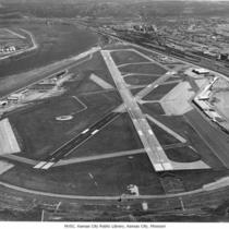
Title
-
Municipal Airport
-
Description
-
Aerial view of Municipal Airport, looking toward the north. The Missouri River can be seen at the top left portion of the photograph. View includes the full runway and airport facilities as well as part of North Kansas City.
-
Date
-
1975-04-17
-
Object Type
-
Photograph
-

-
Title
-
Municipal Airport Future Site
-
Description
-
Aerial view of New Richards Field which soon became known as Municipal Airport. Shows biplanes on the ground and the second Hannibal Bridge.
-
Date
-
1920~
-
Object Type
-
Photograph
-

-
Title
-
Municipal Airport, Terminal
-
Description
-
Looking northeast, image shows original Municipal Airport terminal with TWA and other airplanes on taxiway and unpaved area in foreground. Midcontinent Airlines building is also visible on the left.
-
Object Type
-
Negative
-

-
Title
-
Municipal Airport
-
Description
-
Low, aerial view of Municipal Airport, looking toward the south with the Kansas City, Missouri skyline in view. A portion of the runway and the airport terminal building are visible as well as various airplanes on the ground. The Broadway Bridge, 2nd Hannibal Bridge and ASB Bridge can be seen crossing the Missouri River.
-
Date
-
1970~
-
Object Type
-
Photograph
-

-
Title
-
Municipal Airport
-
Description
-
View of Kansas City's Municipal Airport looking toward the northeast. The airport terminal building is in view as well as a portion of the runway. Several prop airplanes can be seen, including at least one TWA airplane.
-
Date
-
1950~
-
Object Type
-
Photograph
-
-
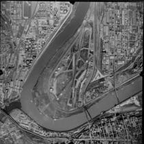
Title
-
Municipal Airport, Aerial View
-
Description
-
Aerial view of the Municipal Airport showing runways and terminal. Missouri River travels from the north at the top of the frame and bends to the right, and the Kansas (Kaw) River meets up with the Missouri in the lower left corner. The Broadway Bridge crosses the river just south of the airport, and to the east is the ASB (Armour-Swift-Burlington) Bridge which then carried rail and automobile traffic. The Harlem neighborhood runs along the north bank of the Missouri to the east of the airport, and the city of North Kansas City, Missouri, runs along the length of the left side of the image north of Harlem. Kansas City, Kansas, can be seen to the west of the Missouri River.
-
Date
-
1971-11-07
-
Object Type
-
Negative
-

-
Title
-
Aerial View of Downtown Kansas City
-
Description
-
Aerial view of downtown Kansas City and portions of North Kansas City, Missouri, looking toward the northwest. The Municipal Airport is in view as well as the Missouri River as it bends to the north. The Fairfax Airport is on the west side of the river. The Broadway Bridge, 2nd Hannibal Bridge, and the ASB Bridge, in that order from left to right, can be seen spanning the river. The Fairfax Bridge can be seen in the distance beyond the airport.
-
Date
-
1960~
-
Object Type
-
Photograph
-

-
Title
-
Aerial View of Downtown Kansas City
-
Description
-
Aerial view of downtown Kansas City and portions of North Kansas City, Missouri, looking toward the northwest. The Municipal Airport is in view as well as the Missouri River as it bends to the north The Broadway Bridge, 2nd Hannibal Bridge, and the ASB Bridge, in that order from left to right, can be seen spanning the river. The Fairfax Bridge can be seen in the distance beyond the airport.
-
Date
-
1960-12
-
Object Type
-
Photograph

