Askren Photograph Collection
-
-
Title
-
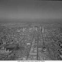
Aerial View of Downtown Kansas City
-
Description
-
Aerial view looking north with Union Station and Western Auto/Coca Cola building in the foreground and General Hospital to the right.
-
Date
-
1962-11-20
-
Object Type
-
Negative
-

-
Title
-
Aerial View of Downtown Kansas City
-
Description
-
Aerial view of downtown Kansas City and portions of North Kansas City, Missouri, looking toward the northwest. The Municipal Airport is in view as well as the Missouri River as it bends to the north. The Broadway Bridge, 2nd Hannibal Bridge, and the ASB Bridge, in that order from left to right, can be seen spanning the river. No print image; negative and digital only.
-
Date
-
1962-11-20
-
Object Type
-
Negative
-

-
Title
-
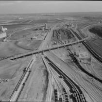
Blue Valley Industrial District
-
Description
-
Aerial view looking north shows the Blue River, also known as the Big Blue, cutting through the center of the image, with 12th Street crossing over. The left foreground of the image shows The Ruberoid Co., manufacturers of asphalt and asbestos building materials. To the north is Black Sivalls & Bryson Inc., makers of steel products. North of the bridge, in the current location of Interstate 435, is the Centropolis Crusher, a facility for rock crushing. Standard Oil Co. refinery at Sugar Creek is visible in the far background. The Olympic Stadium Midget Auto Racetrack at 7900 Truman Road is visible south of 12th Street and east of the river. As of 2010, the Olympic Stadium site is now home to Pick-n-Pull used auto parts lot. The Standard Oil Refinery, later Amoco Oil Company, closed in the 1980s.
-
Date
-
1962-11-20
-
Object Type
-
Negative
-

-
Title
-
Aerial View of Downtown Kansas City
-
Description
-
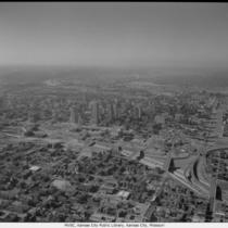
Aerial view of downtown Kansas City, Missouri, looking west with Interstate 70 (I-70) and northeast portion of the downtown loop on the right. No print image; negative and digital only.
-
Date
-
1962-11-20
-
Object Type
-
Negative
-

-
Title
-
Aerial View of Downtown Kansas City
-
Description
-
Aerial view of downtown Kansas City looking mostly west with Interstate 70 (I-70) on the right and the northeast loop. No print image; negative and digital only.
-
Date
-
1962-11-20
-
Object Type
-
Negative
-
-
Title
-
Aerial View of Downtown Kansas City
-
Description
-
Aerial view of downtown Kansas City looking west with Interstate 70 (I-70) on the right.
-
Date
-
1962-11-20
-
Object Type
-
Negative
-

-
Title
-
Blue Valley Industrial District
-
Description
-
Aerial view looking north shows the Blue River, also known as the Big Blue, cutting through the center of the image, with 12th Street crossing over. In the left foreground, a portion of The Ruberoid Co. (manufacturers of asphalt and asbestos building materials) is visible. Just north of that is the parking lot of Black Sivalls & Bryson Inc. (makers of steel products). North of the bridge, in the current location of Interstate 435, is the Centropolis Crusher, a facility for rock crushing. Just out of sight on the south of 12th and east of Blue River is the Olympic Stadium Midget Auto Racetrack.
-
Date
-
1962-11-20
-
Object Type
-
Negative