Pages
-

-
Title
-
Residential Area
-
Description
-
View of an unidentified residential section in the Pershing Road area, including backyards and vacant lots. Exact location unknown.
-
Object Type
-
Photograph
-

-
Title
-
Tuberculosis Hospital
-
Description
-
Exterior view of Kansas City Tuberculosis Hospital built by prisoners of the Municipal Farm in Leeds "under the supervision of the architect and necessary foremen." Prior to the completion of the hospital, patients were cared for in a tent colony on a hill just east of the building beginning in 1913. The hospital opened Christmas Day 1915 with 18 patients from the tent colony. ("Jackson County Medical Journal," Vol. 26, No. 39, pp. 7-11) The building was razed in 1971 ("Kansas City Star," October 8, 1995, page 4). Address in 1916 city directory simply says Leeds, Mo. In 1932, it was listed as being at 1410 Raytown Road, and in 1942 and 1955 at 4210 Raytown Road.
-
Object Type
-
Photograph
-

-
Title
-
Police Memorial Ceremony
-
Description
-
Ceremony at Police Memorial, at its original location at 15th Street and The Paseo.
-
Object Type
-
Photograph
-

-
Title
-
Alfred Benjamin Memorial
-
Description
-
Unidentified child standing before the Alfred Benjamin Memorial in Swope Park.
-
Object Type
-
Photograph
-

-
Title
-
Police Memorial Ceremony
-
Description
-
Ceremony at Police Memorial, at its original location at 15th Street and The Paseo.
-
Object Type
-
Photograph
-

-
Title
-
Municipal Stadium
-
Description
-
Aerial view, looking south, of Municipal Stadium, located at 22nd and Brooklyn, on a game day.
-
Object Type
-
Photograph
-

-
Title
-
Turkey Creek Pumping Station
-
Description
-
View of debris from the 1951 Flood outside the Turkey Creek Pumping Station.
-
Date
-
1951
-
Object Type
-
Photograph
-

-
Title
-
Flood Damaged Area
-
Description
-
Street level view of the Columbian Steel Tank Company building, showing damage from 1951 Flood.
-
Date
-
1951
-
Object Type
-
Photograph
-

-
Title
-
Water Works, East Bottom Pumping Station
-
Description
-
Kansas City Water Works, East Bottom Pumping Station, located on the south side of the 3300 block on Nicholson Avenue near N. Indiana Avenue. The adjacent water reservoir is not in view.
-
Object Type
-
Photograph
-
-
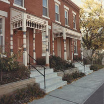
Title
-
Union Park Row Houses
-
Description
-
Row houses in the Union Hill area, 29th and Main streets. Duncan Architects, Inc. received an award for its work in the renovation of these buildings.
-
Date
-
1986
-
Object Type
-
Photograph
-

-
Title
-
Quality Hill and Kersey Coates Drive
-
Description
-
View facing northeast of Quality Hill, West Terrace Park, and Kersey Coates Drive in the aftermath of the 1951 Flood.
-
Date
-
1951
-
Object Type
-
Photograph
-

-
Title
-
Sheffield Pool
-
Description
-
View of unidentified children swimming at Sheffield Pool and Shelter Building.
-
Object Type
-
Photograph
-
-
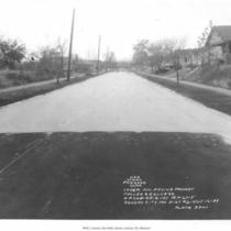
Title
-
Road Paving Project
-
Description
-
View of a WPA road paving project in Independence, Missouri, near the intersection of Fuller and College.
-
Date
-
1939-11-16
-
Object Type
-
Photograph
-

-
Title
-
General Hospital No. 1
-
Description
-
Interior view, looking down a hallway. Identified on the photograph as: "Corridor N.E. 5, General Hospital No. 1, May 20, 1941."
-
Date
-
1941
-
Object Type
-
Photograph
-

-
Title
-
Nutrition/Food Services in Hospital
-
Description
-
Interior view, identified on back of photograph as a new diet kitchen located in General Hospital No. 1. Photo appeared in the City Manager's annual report, 1941, p. 43, MVSC Q 092.52 K16, 1940-48, and captioned as "Diet kitchen after remodeling."
-
Date
-
1941
-
Object Type
-
Photograph
-

-
Title
-
Hospital Adult Patient Care
-
Description
-
Interior view looking down a hospital ward with patients and hospital personnel in view. Identified as Tumor Ward at General Hospital No. 1. This photograph appeared in the published city manager's annual report for 1941, p. 43, MVSC Q092.52 K16, 1940-48. It is captioned: "A typical ward after renovating."
-
Date
-
1941
-
Object Type
-
Photograph
-

-
Title
-
Road Paving Project
-
Description
-
Unidentified men working on a WPA road paving project in Independence, Missouri, near the intersection of Chrysler Avenue and Maple.
-
Date
-
1939-11-16
-
Object Type
-
Photograph
-

-
Title
-
Drainage Canal
-
Description
-
View of a drainage canal near Fort Osage, a WPA work project located north of Buckner, Missouri.
-
Date
-
1939-03-28
-
Object Type
-
Photograph
-

-
Title
-
Stone Bridge
-
Description
-
View of stone bridge and home on Pembroke Lane in the Country Club District.
-
Object Type
-
Photograph
Pages

