Photographs (General Collection)
Pages
-
-
Title
-
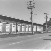
Liberty Street in the West Bottoms
-
Description
-
Street level view of Liberty Street between 14th and 16th streets in the West Bottoms. View is looking north/northwest. Believed to be the east side of the building showing loading docks.
-
Date
-
1999
-
Object Type
-
Photograph
-

-
Title
-
Union Avenue in the West Bottoms
-
Description
-
Street level view of 1321-29 Union Avenue located in the West Bottoms of Kansas City, Missouri. Two businesses shown include Phillips Fender Guides at 1321 Union and Working in the Dirt at 1323 Union.
-
Date
-
1999
-
Object Type
-
Photograph
-

-
Title
-
Hickory Street in the West Bottoms
-
Description
-
Street level view of the southwest corner of Hickory Street at 13th Street in the West Bottoms area of Kansas City, Missouri. Includes warehouse building located on that corner.
-
Date
-
1999
-
Object Type
-
Photograph
-

-
Title
-
Broadway Boulevard
-
Description
-
Street level view looking north on Broadway at 39th Street intersection. Buildings in immediate view to be removed for new drugstore construction. Tobler Flowers sign in view on building.
-
Date
-
1999
-
Object Type
-
Photograph
-

-
Title
-
Park Manor Apartments
-
Description
-
Partial frontal view of Park Manor Apartments, 4800 Roanoke Parkway, west side of street.
-
Date
-
1999
-
Object Type
-
Photograph
-

-
Title
-
West Bottoms
-
Description
-
Street level view of the remains of the Loose-Wiles Biscuit Company building located in the West Bottoms area of Kansas City, Missouri. The fire occurred in July of 1998. The view is looking to the west/northwest.
-
Date
-
1999
-
Object Type
-
Photograph
-
-
Title
-
West Bottoms
-
Description
-
Street level view of the west side of Wyoming Street between 14th and 15th streets in the West Bottoms area of Kansas City, Missouri. View is looking north and shows fire damage to the buildilng. Structure is thought to be a former railway freight building.
-
Date
-
1999
-
Object Type
-
Photograph
-
-
Title
-
West Bottoms
-
Description
-
Street level view of the southeast corner of 13th Street and Union Avenue located in the West Bottoms area of Kansas City, Missouri. Building in view on corner is a former post office.
-
Date
-
1999
-
Object Type
-
Photograph
-

-
Title
-
Baltimore Avenue
-
Description
-
Street level view looking south on Baltimore Avenue between 11th Street and 12th Street in downtown Kansas City, Missouri. View includes the Italian Gardens restaurant located at 1110 Baltimore with a building identified on an old building sign as the Hotel Bray next to it. The Muehlebach Hotel can be seen farther down the street. The Italian Gardens restaurant was demolished in 2006.
-
Date
-
1999
-
Object Type
-
Photograph
-

-
Title
-
Baltimore Avenue
-
Description
-
Street level view of the west side of 2221 Baltimore looking north. This area is in the Crossroads Arts District located in Kansas City's midtown area. Sign in view reads "Opie Brush Co."
-
Date
-
1999
-
Object Type
-
Photograph
-

-
Title
-
Baltimore Avenue and 14th Street
-
Description
-
Street level view of the southwest corner of the intersection of Baltimore Avenue and 14th Street. View is looking toward the southwest. Building in view appears to be vacant.
-
Date
-
1999
-
Object Type
-
Photograph
-

-
Title
-
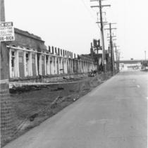
Loose-Wiles Biscuit Company Building
-
Description
-
Street level view of the remains of the Loose-Wiles Biscuit Company building located in the West Bottoms area of Kansas City, Missouri. The building was destroyed by a fire in July of 1998.
-
Date
-
1999
-
Object Type
-
Photograph
-

-
Title
-
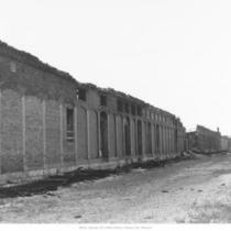
Loose-Wiles Biscuit Company Building
-
Description
-
Street level view of the remains of the Loose-Wiles Biscuit Company building located in the West Bottoms area of Kansas City, Missouri. The building was destroyed by a fire that occurred in July of 1998.
-
Date
-
1999
-
Object Type
-
Photograph
-

-
Title
-
Loose-Wiles Biscuit Company Building
-
Description
-
Street level view of the remains of the Loose-Wiles Biscuit building in the West Bottoms area of Kansas City, Missouri. The building was destroyed by a fire in July, 1998.
-
Date
-
1999
-
Object Type
-
Photograph
-
-
Title
-
West Bottoms
-
Description
-
View of west side of Wyoming Street alley between 14th and 15th streets. Shows fire damage to the structure located in the West Bottoms area of Kansas City, Missouri.
-
Date
-
1999
-
Object Type
-
Photograph
-

-
Title
-
West Bottoms
-
Description
-
Street level view, looking northwest, of Wyoming Street between 14th and 15th streets in the West Bottoms area of Kansas City, Missouri. View shows a fire damaged building believed to be a former railway freight building.
-
Date
-
1999
-
Object Type
-
Photograph
-

-
Title
-
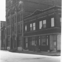
Boley Building
-
Description
-
View of Boley Building looking southwest on Walnut between 11th and 12th.
-
Date
-
1999
-
Object Type
-
Photograph
-
-
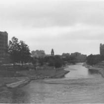
Title
-
Brush Creek
-
Description
-
Exterior view, looking east, of Brush Creek flowing through the Country Club Plaza area.
-
Date
-
1999
-
Object Type
-
Photograph
-

-
Title
-
West Bottoms
-
Description
-
Street level view of the corner of St. Louis Avenue (1400 block) and Hickory Street in the West Bottoms area of Kansas City, Missouri. The Bartels & Shores Chemical Company is located in building on the right.
-
Date
-
1999
-
Object Type
-
Photograph
-

-
Title
-
Lidia's Restaurant
-
Description
-
Exterior, street level view of Lidia's Restaurant serving Italian cuisine. It is located at 101 West 22nd Street, just north of Union Station in Kansas City, Missouri, and is near the Crossroads District in the midtown area.
-
Date
-
1999
-
Object Type
-
Photograph
Pages
