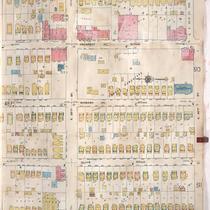
Pages
-
-
Title
-
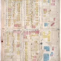
Sanborn Map, Kansas City, Vol. 4, 1909-1957, Page p495
-
Description
-
A portion of Kansas City from Valentine Road south to W. 38th Street and from Belleview Avenue east to Jefferson, showing buildings, streets, and additions. Large numbers at edges of page refer to page with adjoining area.
-
Date
-
1909/1957
-
Object Type
-
Map
-

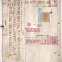
-
Title
-
Sanborn Map, Kansas City, Vol. 4, 1909-1957, Page p472
-
Description
-
A portion of Kansas City from E. 31st Street south to E. 33rd Street and from Olive Street east to Montgall Avenue, showing buildings, streets, and additions. Large numbers at edges of page refer to page with adjoining area.
-
Date
-
1909/1957
-
Object Type
-
Map
-
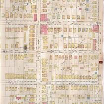
-
Title
-
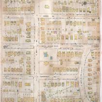
Sanborn Map, Kansas City, Vol. 4, 1909-1957, Page p475
-
Description
-
A portion of Kansas City from W. 35th Street south to Valentine Road and from Jefferson Street east to Broadway, showing buildings, streets, and additions. Large numbers at edges of page refer to page with adjoining area.
-
Date
-
1909/1957
-
Object Type
-
Map
-

-
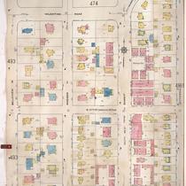
Title
-
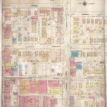
Sanborn Map, Kansas City, Vol. 4, 1909-1957, Page p474
-
Description
-
A portion of Kansas City from W. 36th Street south to Valentine Road and from Belleview Avenue east to Jefferson Street, showing buildings, streets, and additions. Large numbers at edges of page refer to page with adjoining area.
-
Date
-
1909/1957
-
Object Type
-
Map
-

-
Title
-
Sanborn Map, Kansas City, Vol. 4, 1909-1957, Page p486
-
Description
-
A portion of Kansas City from E. 35th Street south to E. 36th Street and from Michigan Avenue east to Park Avenue, showing buildings, streets, and additions. Large numbers at edges of page refer to page with adjoining area.
-
Date
-
1909/1957
-
Object Type
-
Map
-

-
Title
-
Sanborn Map, Kansas City, Vol. 4, 1909-1957, Page p479
-
Description
-
A portion of Kansas City from E. 34th Street south to E. 36th Street and from Locust east to Holmes Street, showing buildings, streets, and additions. Large numbers at edges of page refer to page with adjoining area.
-
Date
-
1909/1957
-
Object Type
-
Map
-
-
Title
-
Sanborn Map, Kansas City, Vol. 4, 1909-1957, Page p488
-
Description
-
A portion of Kansas City from E. 35th Street south to E. 36th Street and from Park Avenue east to Montgall Avenue, showing buildings, streets, and additions. Large numbers at edges of page refer to page with adjoining area.
-
Date
-
1909/1957
-
Object Type
-
Map
-
-
Title
-
Sanborn Map, Kansas City, Vol. 4, 1909-1957, Page p484
-
Description
-
A portion of Kansas City from E. 35th Street south to E. 36th Street and from Flora Avenue east to Michigan Avenue, showing buildings, streets, and additions. Large numbers at edges of page refer to page with adjoining area.
-
Date
-
1909/1957
-
Object Type
-
Map
-

-
Title
-
Sanborn Map, Kansas City, Vol. 4, 1909-1957, Page p470
-
Description
-
A portion of Kansas City from E. 31st Street south to E. 33rd Street and from Woodland Avenue east to Garfield Avenue, showing buildings, streets, and additions. Large numbers at edges of page refer to page with adjoining area.
-
Date
-
1909/1957
-
Object Type
-
Map
-

-
Title
-
Sanborn Map, Kansas City, Vol. 4, 1909-1950, Page p480
-
Description
-
A portion of Kansas City from E. 34th Street south to E. 36th Street and from Holmes Avenue east to Harrison Boulevard, showing buildings, streets, and additions. Large numbers at edges of page refer to page with adjoining area.
-
Date
-
1909/1950
-
Object Type
-
Map
-
-
Title
-
Sanborn Map, Kansas City, Vol. 4, 1909-1950, Page p547
-
Description
-
A portion of Kansas City from E. 45th Street south to E. 47th Street and from Forest Avenue east to The Paseo, showing buildings, streets, and additions. Large numbers at edges of page refer to page with adjoining area.
-
Date
-
1909/1950
-
Object Type
-
Map
-

-
Title
-
Sanborn Map, Kansas City, Vol. 4, 1909-1950, Page p553
-
Description
-
A portion of Kansas City from W. 41st Street south to W. 42nd Street and from State Line east to Terrace, showing buildings, streets, and additions. Large numbers at edges of page refer to page with adjoining area.
-
Date
-
1909/1950
-
Object Type
-
Map
-

-
Title
-
Sanborn Map, Kansas City, Vol. 4, 1909-1957, Page p489
-
Description
-
A portion of Kansas City from E. 33rd Street south to E. 34th Street and from Montgall Avenue east to Bellefontaine Avenue, showing buildings, streets, and additions. Large numbers at edges of page refer to page with adjoining area.
-
Date
-
1909/1957
-
Object Type
-
Map
-

-
Title
-
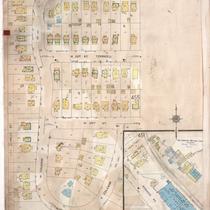
Sanborn Map, Kansas City, Vol. 4, 1909-1957, Page p453
-
Description
-
A portion of Kansas City from W. 31st Street south to W. 33rd Street and from Karnes Boulevard east to Pennsylvania Avenue, showing buildings, streets, and additions. Large numbers at edges of page refer to page with adjoining area.
-
Date
-
1909/1957
-
Object Type
-
Map
-

-
Title
-
Sanborn Map, Kansas City, Vol. 4, 1909-1957, Page p498
-
Description
-
A portion of Kansas City from W. 38th Street south to W. 40th Street and from Pennsylvania Avenue east to Broadway, showing buildings, streets, and additions. Large numbers at edges of page refer to page with adjoining area.
-
Date
-
1909/1957
-
Object Type
-
Map
-

-
Title
-
Sanborn Map, Kansas City, Vol. 4, 1909-1957, Page p461
-
Description
-
A portion of Kansas City from E. 31st Street south to E. Linwood Boulevard and from McGee east to Gillham Road, showing buildings, streets, and additions. Large numbers at edges of page refer to page with adjoining area.
-
Date
-
1909/1957
-
Object Type
-
Map
-
-
Title
-
Sanborn Map, Kansas City, Vol. 4, 1909-1950, Page p490
-
Description
-
A portion of Kansas City from E. 35th Street south to E. 36th Street and from Montgall Avenue east to Agnes Avenue, showing buildings, streets, and additions. Large numbers at edges of page refer to page with adjoining area.
-
Date
-
1909/1950
-
Object Type
-
Map
-

-
Title
-
Sanborn Map, Kansas City, Vol. 4, 1909-1950, Page p470
-
Description
-
A portion of Kansas City from E. 31st Street south to E. 33rd Street and from Woodland Avenue east to Garfield Avenue, showing buildings, streets, and additions. Large numbers at edges of page refer to page with adjoining area.
-
Date
-
1909/1950
-
Object Type
-
Map
-
-
Title
-
Sanborn Map, Kansas City, Vol. 4, 1909-1950, Page p463
-
Description
-
A portion of Kansas City from E. 31st Street south to E. Linwood Boulevard and from Gillham Road east to Campbell Street, showing buildings, streets, and additions. Large numbers at edges of page refer to page with adjoining area.
-
Date
-
1909/1950
-
Object Type
-
Map
-
-
Title
-
Sanborn Map, Kansas City, Vol. 4, 1909-1950, Page p577
-
Description
-
A portion of Kansas City from W. 33rd Street south to W. 34th Street and from Holly Street east to Coleman Road, showing buildings, streets, and additions. Large numbers at edges of page refer to page with adjoining area. At top of map, "Add'l Sheet, Dec. 1921."
-
Date
-
1909/1950
-
Object Type
-
Map
Pages
