Pages
-

-
Title
-
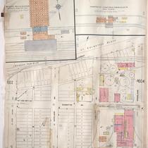
Sanborn Map, Kansas City, Vol. 5, 1909-1938, Page p611
-
Description
-
A portion of Kansas City from Nicholson Avenue south to Rochester Avenue and from N. Olive east to N. Prospect Avenue, showing buildings, streets, railroads, and additions. Large numbers at edges of page refer to page with adjoining area.
-
Date
-
1909/1938
-
Object Type
-
Map
-

-
Title
-
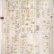
Sanborn Map, Kansas City, Vol. 5, 1909-1938, Page p683
-
Description
-
A portion of Kansas City from E. 25th Street south to E. 27th Street and from Cleveland Avenue east to Norton Avenue, showing buildings, streets, and additions. Large numbers at edges of page refer to page with adjoining area.
-
Date
-
1909/1938
-
Object Type
-
Map
-

-
Title
-
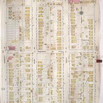
Sanborn Map, Kansas City, Vol. 5, 1909-1938, Page p616
-
Description
-
A portion of Kansas City from Gladstone Boulevard south to Norledge Avenue and from N. Lawndale Avenue east to N. White Avenue, showing buildings, streets, and additions. Large numbers at edges of page refer to page with adjoining area.
-
Date
-
1909/1938
-
Object Type
-
Map
-

-
Title
-
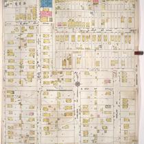
Sanborn Map, Kansas City, Vol. 5, 1909-1938, Page p635
-
Description
-
A portion of Kansas City from Independence Avenue south to E. 8th Street and from Cleveland Avenue east to Norton Avenue, showing buildings, streets, and additions. Large numbers at edges of page refer to page with adjoining area.
-
Date
-
1909/1938
-
Object Type
-
Map
-

-
Title
-
Sanborn Map, Kansas City, Vol. 5, 1909-1938, Page p659
-
Description
-
A portion of Kansas City from E. 12th Street south to E. 15th Street and from Oakley Avenue east to Bellaire Avenue, showing buildings, streets, and additions. Large numbers at edges of page refer to page with adjoining area.
-
Date
-
1909/1938
-
Object Type
-
Map
-
-
Title
-
Sanborn Map, Kansas City, Vol. 5, 1909-1938, Page p603
-
Description
-
A portion of Kansas City from E. Front Street south to E. 1st Street and from N. Vine Street east to Woodland Avenue, showing buildings, streets, railroads, and additions. Large numbers at edges of page refer to page with adjoining area.
-
Date
-
1909/1938
-
Object Type
-
Map
-

-
Title
-
Sanborn Map, Kansas City, Vol. 5, 1909-1938, Page p714
-
Description
-
A portion of Kansas City from Saint John Avenue south to Smart Avenue and from White Avenue east to Belmont Avenue, showing buildings, streets, and additions. Large numbers at edges of page refer to page with adjoining area. At the top of page, "Add'l Sheet, Dec. 1916."
-
Date
-
1909/1938
-
Object Type
-
Map
-
-
Title
-
Sanborn Map, Kansas City, Vol. 5, 1909-1938, Page p671
-
Description
-
A portion of Kansas City from E. 17th Street south to E. 20th Street and from Kensington Avenue east to Lawn Avenue, showing buildings, streets, and additions. Large numbers at edges of page refer to page with adjoining area.
-
Date
-
1909/1938
-
Object Type
-
Map
-

-
Title
-
Sanborn Map, Kansas City, Vol. 5, 1909-1938, Page p605
-
Description
-
A portion of Kansas City from E. Front Street south to Guinotte Avenue and from N. Garfield Avenue east to N. Park Avenue, showing buildings, streets, and additions. Large numbers at edges of page refer to page with adjoining area.
-
Date
-
1909/1938
-
Object Type
-
Map
-

-
Title
-
Sanborn Map, Kansas City, Vol. 5, 1909-1938, Page p617
-
Description
-
A portion of Kansas City from Norledge Avenue south to Saint John Avenue and from N. Monroe Avenue east to Clinton Place, showing buildings, streets, and additions. Large numbers at edges of page refer to page with adjoining area.
-
Date
-
1909/1938
-
Object Type
-
Map
-
-
Title
-
Sanborn Map, Kansas City, Vol. 5, 1909-1938, Page p630
-
Description
-
A portion of Kansas City from Saint John Avenue south to Smart Avenue and from Hardesty Avenue east to Lawndale Avenue, showing buildings, streets, and additions. Large numbers at edges of page refer to page with adjoining area.
-
Date
-
1909/1938
-
Object Type
-
Map
-

-
Title
-
Sanborn Map, Kansas City, Vol. 5, 1909-1938, Page p724
-
Description
-
A portion of Kansas City in the Leed's Industrial District, showing buildings, streets, and railroads. Large numbers at edges of page refer to page with adjoining area. At the top of page, "Add'l Sheet, Nov. 1928."
-
Date
-
1909/1938
-
Object Type
-
Map
-

-
Title
-
Sanborn Map, Kansas City, Vol. 5, 1909-1938, Page p681
-
Description
-
A portion of Kansas City from E. 24th Street south to E. 25th Street and from Lawn Avenue east to Brighton Avenue, showing buildings, streets, and additions. Large numbers at edges of page refer to page with adjoining area.
-
Date
-
1909/1938
-
Object Type
-
Map
-

-
Title
-
Sanborn Map, Kansas City, Vol. 5, 1909-1938, Page p604
-
Description
-
A portion of Kansas City from E. Front Street south to E. 1st Street and from N. Woodland Avenue east to Garfield Avenue, showing buildings, streets, railroads, and additions. Shows The Kansas City Star printing paper storage house. Large numbers at edges of page refer to page with adjoining area.
-
Date
-
1909/1938
-
Object Type
-
Map
-

-
Title
-
Sanborn Map, Kansas City, Vol. 5, 1909-1938, Page p689
-
Description
-
A portion of Kansas City at the intersection of Cambridge Avenue and Winner Road, showing buildings, streets, railroads, and additions. Large numbers at edges of page refer to page with adjoining area. At the top of page, "New Sheet May 1922."
-
Date
-
1909/1938
-
Object Type
-
Map
-
-
Title
-
Sanborn Map, Kansas City, Vol. 5, 1909-1938, Page p672
-
Description
-
A portion of Kansas City from E. 17th Street south to E. 20th Street and from Lawn Avenue east to Brighton Avenue, showing buildings, streets, and additions. Large numbers at edges of page refer to page with adjoining area.
-
Date
-
1909/1938
-
Object Type
-
Map
-

-
Title
-
Sanborn Map, Kansas City, Vol. 5, 1909-1938, Page p642
-
Description
-
A portion of Kansas City from E. 11th Street south to E. 13th Street and from Cleveland Avenue east to Norton Avenue, showing buildings, streets, and additions. Large numbers at edges of page refer to page with adjoining area.
-
Date
-
1909/1938
-
Object Type
-
Map
-

-
Title
-
Sanborn Map, Kansas City, Vol. 5, 1909-1938, Page p709
-
Description
-
A portion of Kansas City from E. 10th Street south to E. 12th Street and from Crystal Avenue east to Eastern Avenue, showing buildings, streets, railroads, and additions. Large numbers at edges of page refer to page with adjoining area. At the top of page, "Add'l Sheet, Aug. 1912."
-
Date
-
1909/1938
-
Object Type
-
Map
-

-
Title
-
Sanborn Map, Kansas City, Vol. 5, 1909-1938, Page p633
-
Description
-
A portion of Kansas City from Smart Avenue south to Independence Avenue and from Hardesty Avenue east to Lawndale Avenue, showing buildings, streets, and additions. Large numbers at edges of page refer to page with adjoining area.
-
Date
-
1909/1938
-
Object Type
-
Map
Pages

