-
-
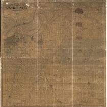
Title
-
Edwards' Map of Jackson Co., Missouri
-
Description
-
Plat map of Jackson County, Missouri, and the southern extents of Clay County and Ray County, along the north bank of the Missouri River. Cities and towns, rivers, and parcels of land labeled with their owners' names are shown.
-
Date
-
1887
-
Object Type
-
Map
-

-
Title
-
Map of Jackson County, Missouri
-
Description
-
Plat map of Jackson County, Missouri. Cities and towns, rivers, and parcels of land labeled with their owners' names are shown. A list of rural routes is included.
-
Date
-
1909
-
Object Type
-
Map
-
![Map of Jackson County, Missouri [Southern Section]](https://kchistory.org/sites/default/files/styles/islandora_imagecache_image_style_medium/public/externals/e29099cb1563d7af72b6972249d0e6f0.jpg?itok=ZS44X5kY&pid=kchistory:106275&iic=true&solr_nav%5Bid%5D=2ef85ab77c74c1318c00&solr_nav%5Bpage%5D=0&solr_nav%5Boffset%5D=2)
-
Title
-
Map of Jackson County, Missouri [Southern Section]
-
Description
-
Land ownership map of the southern part of Jackson County, Missouri, showing railroads, electric railroads, highways (macadamized, graded, main), rural mail routes, streams, churches, school houses, and cemeteries. Includes the townships of Westport, Brooking, Washington, Prairie, and Van Buren, as well as the cities of Blue Springs, Martin City, and Grandview. The map draftsmen are identified as Jas. H. Southwell, A. H. Doty, and A. W. Hirsh.
-
Date
-
1909~
-
Object Type
-
Map
