Pages
-

-
Title
-
38th and Main at Night
-
Description
-
Elevated nighttime view looking northwest of the intersection of 38th and Main Streets in Midtown. The Price Building can be seen on the left hand side of the image. The Hyde Park Building is visible on the right. Sign's for Price's Drugs, South Side Bank of Kansas City, and Crown Drug can be seen. Cars parked and traveling along 38th and Main streets are in view.
-
Date
-
1935~
-
Object Type
-
Photograph
-

-
Title
-
3900 Block of Main Street
-
Description
-
Photograph of buildings on the west side of the intersection of 39th and Main Streets in the early 1980s. Muehlebach Flowers, at 3934 Main Street, is picture, as is a free-standing restaurant building that had been vacated by a Denny's restaurant in 1982. Calvary Baptist Church, at 3921 Baltimore, can be seen in the background on the opposite side of the block. The Price Candy Company Building, occupied by the Foolkiller Theater company, can be seen on the northwest corner of the intersection.
-
Date
-
1980~/1989~
-
Object Type
-
Photograph
-

-
Title
-
3910 Main Street
-
Description
-
Photograph of a vacant building at 3910 Main Street, circa 1983. The building was originally a Denny's restaurant that closed in 1982. Rosie's Bakery and Deli opened in the building in 1983. Foolkiller Theater, on the northwest corner of 39th and Main, can be seen in the background of the image. The restaurant building and gas station to the north were demolished in 1998.
-
Date
-
1983~
-
Object Type
-
Photograph
-

-
Title
-
3916 Broadway Boulevard
-
Description
-
Photograph circa 1980s of Astaur Gulaian ; Son Oriental Rugs store at 3916 Broadway Boulevard. Gulaian moved into this building ca. 1930; the business closed in 1989. Located in the Westport neighborhood.
-
Date
-
1980~/1989~
-
Object Type
-
Photograph
-
-
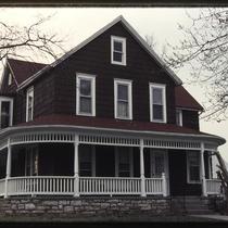
Title
-
4026 Central Street
-
Description
-
Photograph circa 1980s of the single family home at 4026 Central Street in the Westport neighborhood. It was demolished in 1986. James B. Nutter & Company built an office building in that location.
-
Date
-
1980~/1989~
-
Object Type
-
Photograph
-

-
Title
-
4118-4114 Broadway Boulevard
-
Description
-
Photograph circa 1980s of a building at 4118-4114 Broadway Boulevard, home to several businesses, including Audio Renaissance at 4118 Broadway and Le Mans Family Fun Center at 4116 Broadway. The Greek Islands restaurant, at 4114 Broadway, closed in 1992. At some point after 1992, the building at 4114 Broadway was demolished and a parking lot replaced that space. Located in the Westport neighborhood.
-
Date
-
1980~/1989~
-
Object Type
-
Photograph
-

-
Title
-
4134-36 Broadway Boulevard
-
Description
-
Photograph circa 1980s, looking west, of an apartment building at 4134-36 Broadway Boulevard. At some point after 1986, the building was demolished and a parking lot replaced that space in 1989. Located in the Westport neighborhood.
-
Date
-
1980~/1989~
-
Object Type
-
Photograph
-

-
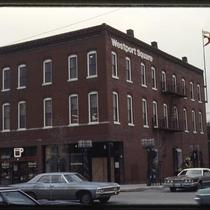
Title
-
42nd and Broadway Building
-
Description
-
View looking north of the building at 42nd Street and Broadway Boulevard in Westport. Pedestrians on Broadway Boulevard can be seen. A portion of the building to the north is in view. Signs for Westport Bank and Mitch's Little Angus can be seen.
-
Date
-
1984~
-
Object Type
-
Photograph
-
-
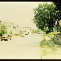
Title
-
4300 Block of Belleview Avenue
-
Description
-
Photograph of the 4300 block of Belleview Avenue, looking north toward Westport Road, circa 1986. An apartment building at 4324-26 Belleview can be seen at the left edge of the image. A yellow and black film developing kiosk can be seen in the background of the image, at the intersection of Belleview, Westport Road, and Summit Street/Southwest Trafficway.
-
Date
-
1986~
-
Object Type
-
Photograph
-
-
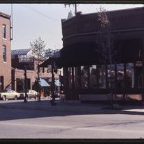
Title
-
433 Westport Road
-
Description
-
Photograph of a the building at 433-35 Westport Road in the late 1970s. Ground floor tenants include Baber's Classic Cup at 433 Westport and Natural Wear, a clothing store, and Earth Shoe outlet, at 435 Westport. The Westport Square development united the buildings on the block bound by Westport Road, Archibald Street, Broadway, and Pennsylvania Avenue into a shopping and dining center with a central courtyard in 1973.
-
Date
-
1970~/1979~
-
Object Type
-
Photograph
-

-
Title
-
433 Westport Road
-
Description
-
Photograph of a the building at 433-35 Westport Road in the late 1970s. Ground floor tenants include Baber's Classic Cup at 433 Westport, and an architecture firm's offices occupy the second floor. The Westport Square development united the buildings on the block bound by Westport Road, Archibald Street, Broadway, and Pennsylvania Avenue into a shopping and dining center with a central courtyard in 1973.
-
Date
-
1970~/1979~
-
Object Type
-
Photograph
-

-
Title
-
44th and Main Intersection
-
Description
-
Photograph of the intersection of 44th and Main Streets, looking south on Main, circa 1987. The Fountain View building (later American Century Investments north tower) is pictured at 4500 Main, with the H&R Block headquarters to its north. The apartments at right were later demolished to allow for expansion of the H&R Block building.
-
Date
-
1987~
-
Object Type
-
Photograph
-
-
Title
-
501 Westport Road
-
Description
-
Photograph circa 1980s of the corner of Westport Road and Pennsylvania Avenue. The building on the right is 501 Westport Road and as of 2018, housed Harry's Bar and Tables restaurant.
-
Date
-
1980~/1989~
-
Object Type
-
Photograph
-

-
Title
-
Apartment Building at 4129 Broadway
-
Description
-
View looking northeast of an apartment building at 4129 Broadway Boulevard in Westport. A portion of the building to the north can be seen on the left hand side of the image.
-
Object Type
-
Photograph
-

-
Title
-
Bird's Eye View - Kansas City
-
Description
-
Pictorial map showing the cities and towns of Kansas City, Missouri; Harlem, Missouri; Westport, Missouri; Rosedale, Kansas; Argentine, Kansas; Armourdale, Kansas; Armstrong, Kansas; Riverview, Kansas; Kansas City, Kansas; and Wyandotte, Kansas. At the time of its publication, the map had an extensive key listing the numbered buildings, most of which has been removed. Steamboats traveling along the Missouri River can be seen. The map displays the steep bluffs and topography of the region. It also indicates Kansas City's expansion southward away from the Missouri River, the development of the stockyards industry in the West Bottoms and interconnectivity with the surrounding cities and towns that followed completion of the Hannibal Bridge in 1869.
-
Date
-
1885~
-
Object Type
-
Map
-

-
Title
-
Black & Decker Parking Lot
-
Description
-
Photograph of a parking lot immediate south of a Black & Decker office building at 4324 Main Street, circa 1980.
-
Date
-
1980~
-
Object Type
-
Photograph
-
-
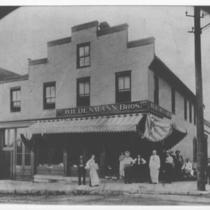
Title
-
Boone's Trading Post (Wiedenmann Brothers Grocery Store)
-
Description
-
View of the Wiedenmann Brothers store with members of the Wiedenmann family and other unidentified people standing outside, located on the northwest corner of Westport Road and Pennsylvania Avenue.
-
Date
-
1904
-
Object Type
-
Photograph
-

-
Title
-
Broadway Boulevard from Valentine Road
-
Description
-
View looking south along Broadway Boulevard from south of its intersection with Valentine Road. Several cars traveling and parked along Broadway can be seen.
-
Date
-
1947~
-
Object Type
-
Photograph
-

-
Title
-
Cars Parked in Country Club Plaza
-
Description
-
An autochrome photograph of two automobiles parked next to a bed of flowers in the Country Club Plaza at the southeast corner of Alameda Road (now Nichols Road) and Central Street. This vantage point faces north-northwest towards the building at the northeast corner of Alameda and Central.
-
Date
-
1935-07-05
-
Object Type
-
Photograph
-

-
Title
-
Elevated View of Westport and St. Luke's Hospital
-
Description
-
Photograph looking northwest from the top of the Fountain View building (later American Century north tower) of the St. Luke's Hospital campus, and buildings in Westport beyond, circa 1987. Hospital buildings occupy the foreground of the image, with the Allen School building and the Westport House senior apartments visible in the background left.
-
Date
-
1980~/1989~
-
Object Type
-
Photograph
Pages
