Pages
-

-
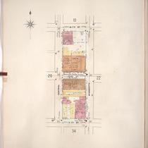
Title
-
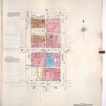
Sanborn Map, Kansas City, Vol. 1, 1909-1938, Page p046
-
Description
-
A portion of Kansas City from W. 17th Street south to W. 19th Street and from the State Line east to Liberty Street, showing buildings, streets, railroads, and additions. Large numbers at edges of page refer to page with adjoining area.
-
Date
-
1909/1938
-
Object Type
-
Map
-
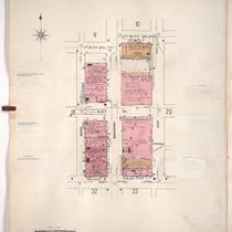
-
Title
-
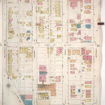
Sanborn Map, Kansas City, Vol. 1, 1909-1938, Page p020
-
Description
-
A portion of Kansas City from W. 7th Street south to W. 9th Street and from May Street east to Central Street, showing buildings, streets, and additions. Large numbers at edges of page refer to page with adjoining area.
-
Date
-
1909/1938
-
Object Type
-
Map
-
-
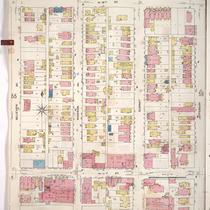
Title
-
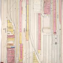
Sanborn Map, Kansas City, Vol. 1, 1909-1938, Page p058
-
Description
-
A portion of Kansas City from W. 18th Street south to W. 20th Street and from Belleview Avenue east to Jefferson Street, showing buildings, streets, and additions. Large numbers at edges of page refer to page with adjoining area.
-
Date
-
1909/1938
-
Object Type
-
Map
-

-
Title
-
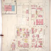
Sanborn Map, Kansas City, Vol. 1, 1909-1938, Page p070
-
Description
-
A portion of Kansas City from W. 23rd Street Trafficway south to W. 25th Street and from Holly Street east to Madison Avenue, showing buildings, streets, and additions. Large numbers at edges of page refer to page with adjoining area.
-
Date
-
1909/1938
-
Object Type
-
Map
-

-
Title
-
Sanborn Map, Kansas City, Vol. 1, 1909-1938, Page p038
-
Description
-
A portion of Kansas City from W. 11th Street south to W. 13th Street Terrace and from Hickory east to Mulberry, showing buildings, streets, railroads, and additions. Large numbers at edges of page refer to page with adjoining area.
-
Date
-
1909/1938
-
Object Type
-
Map
-

-
Title
-
Sanborn Map, Kansas City, Vol. 1, 1909-1938, Page p098
-
Description
-
A portion of Kansas City from W. 29th Street south to W. 31st Street and from Holly east to Madison, showing buildings, streets, and additions. Large numbers at edges of page refer to page with adjoining area.
-
Date
-
1909/1938
-
Object Type
-
Map
-

-
Title
-
Sanborn Map, Kansas City, Vol. 1, 1909-1938, Page p067
-
Description
-
A portion of Kansas City from W. 20th Street south to Circle Avenue and from Terrace Place east to Holly, showing buildings, streets, and additions. Large numbers at edges of page refer to page with adjoining area.
-
Date
-
1909/1938
-
Object Type
-
Map
-
-
Title
-
Sanborn Map, Kansas City, Vol. 1, 1909-1938, Page p047
-
Description
-
A portion of Kansas City from W. 14th Street south to W. 16th Street and from Genessee east to Hickory, showing buildings, streets, railroads, and additions. Large numbers at edges of page refer to page with adjoining area.
-
Date
-
1909/1938
-
Object Type
-
Map
-
-
Title
-
Sanborn Map, Kansas City, Vol. 1, 1909-1938, Page p031
-
Description
-
A portion of Kansas City from W. 9th Street south to W. 11th Street and from Summit east to Pennsylvania Avenue, showing buildings, streets, and additions. Large numbers at edges of page refer to page with adjoining area.
-
Date
-
1909/1938
-
Object Type
-
Map
-

-
Title
-
Sanborn Map, Kansas City, Vol. 1, 1909-1938, Page p032
-
Description
-
A portion of Kansas City from W. 9th Street south to W. 11th Street and from Pennsylvania Avenue east to Broadway, showing buildings, streets, and additions. Large numbers at edges of page refer to page with adjoining area.
-
Date
-
1909/1938
-
Object Type
-
Map
-
-
Title
-
Sanborn Map, Kansas City, Vol. 1, 1909-1938, Page p021
-
Description
-
A portion of Kansas City from W. 7th Street south to W. 9th Street and from Central Street east to Wyandotte, showing buildings, streets, and additions. Large numbers at edges of page refer to page with adjoining area.
-
Date
-
1909/1938
-
Object Type
-
Map
-
-
Title
-
Sanborn Map, Kansas City, Vol. 1, 1909-1938, Page p095
-
Description
-
A portion of Kansas City from E. 30th Street south to E. 31st Street and from Southwest Boulevard east to Wyoming, showing buildings, streets, and additions. Large numbers at edges of page refer to page with adjoining area.
-
Date
-
1909/1938
-
Object Type
-
Map
-

-
Title
-
Sanborn Map, Kansas City, Vol. 1, 1909-1938, Page p089
-
Description
-
A portion of Kansas City from W. 26th Street Terrace south to W. 28th Street and from Southwest Boulevard east to Jarboe, showing buildings, streets, and additions. Large numbers at edges of page refer to page with adjoining area.
-
Date
-
1909/1938
-
Object Type
-
Map
-

-
Title
-
Sanborn Map, Kansas City, Vol. 1, 1909-1938, Page p062
-
Description
-
A portion of Kansas City from W. 16th Street south to W. 18th Street and from Wyandotte east to Main Street, showing buildings, streets, and additions. Large numbers at edges of page refer to page with adjoining area.
-
Date
-
1909/1938
-
Object Type
-
Map
-
-
Title
-
Sanborn Map, Kansas City, Vol. 1, 1909-1938, Page p057
-
Description
-
A portion of Kansas City from W. 16th Street south to W. 17th Street and from Belleview Avenue east to Jefferson, showing buildings, streets, and additions. Large numbers at edges of page refer to page with adjoining area.
-
Date
-
1909/1938
-
Object Type
-
Map
-

-
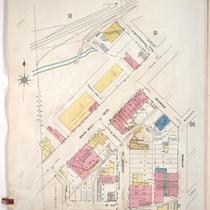
Title
-
Sanborn Map, Kansas City, Vol. 1, 1909-1938, Page p013
-
Description
-
A portion of Kansas City from W. 8th Street south to W. 9th Street and from N. State Line east to Wyoming, showing buildings, streets, and additions. Large numbers at edges of page refer to page with adjoining area.
-
Date
-
1909/1938
-
Object Type
-
Map
-
-
Title
-
Sanborn Map, Kansas City, Vol. 1, 1909-1938, Page p019
-
Description
-
A portion of Kansas City from W. 7th Street south to W. 9th Street and from Bank Street east to May Street, showing buildings, streets, and additions. Large numbers at edges of page refer to page with adjoining area.
-
Date
-
1909/1938
-
Object Type
-
Map
-

-
Title
-
Sanborn Map, Kansas City, Vol. 1, 1909-1938, Page p094
-
Description
-
A portion of Kansas City from W. 28th Street south to W. 29th Street and from Jarboe east to Summit, showing buildings, streets, and additions. Large numbers at edges of page refer to page with adjoining area.
-
Date
-
1909/1938
-
Object Type
-
Map
-

-
Title
-
Sanborn Map, Kansas City, Vol. 1, 1909-1938, Page p056
-
Description
-
A portion of Kansas City from W. 18th Street south to W. 20th Street and from Terrace Street east to Belleview Avenue, showing buildings, streets, and additions. Large numbers at edges of page refer to page with adjoining area.
-
Date
-
1909/1938
-
Object Type
-
Map
Pages

