Pages
-

-
Title
-
Bates CO. Missouri
-
Description
-
Map of Bates County, Missouri, that includes paved roads, graveled roads, state or county roads not highly improved, roads, interstates and highways, railroads, drainage district line, municipal township lines, streams, and schools. Includes the townships of West Boone, East Boone, Deer Creek, Grand River, Mingo, West Point, Elkhart, Mound, Shawnee, Spruce, Homer, Charlotte, Mount Pleasant, Summit, Deepwater, Walnut, New Home, Lone Oak, Pleasant Gap, Hudson, Howard, Osage, Prairie, and Rockville.
-
Object Type
-
Map
-

-
Title
-
Map of Clay County Missouri
-
Description
-
Map of Clay County, Missouri, including railroads, electric lines, roads, schools, churches, and airports. Includes townships of Platte, Kearney, Washington, Gallatin, Liberty, and Fishing River. Includes cities of Liberty, Excelsior Springs, and North Kansas City. Also includes Kansas City Co. & St. Joe Electric Line.
-
Object Type
-
Map
-

-
Title
-
Road Map of Jackson County, Missouri
-
Description
-
Road map of Jackson County, Missouri, that includes roads, railroads, electric lines, sections lines, streams, township lines, old trails, schools, and churches. Legend indicates types of roads shown. Includes townships of Blue, Fort Osage, Brooking, Sni-a-bar, Washington, Prairie, and Van Buren.
-
Object Type
-
Map
-

-
Title
-
Johnson County, Missouri
-
Description
-
Map of Johnson County, Missouri, that includes highways, county roads, township roads, political township lines, railroads, drainage ditches, streams, and schools. Included are townships Jackson, Columbus, Hazel Hill, Simpson, Grover, Kingsville, Madison, Centerview, Warrensburg, Washington, Montserrat, Rose Hill, Chilhowee, Post Oak, and Jefferson.
-
Object Type
-
Map
-
![Map of Cass County, Mo. [Southern Section]](https://kchistory.org/sites/default/files/styles/islandora_imagecache_image_style_medium/public/externals/0f24d14bdc37d350cece388889339b08.jpg?itok=8FOOtRg_&pid=kchistory:106281&iic=true&solr_nav%5Bid%5D=a54deecf7c2aef6f49f8&solr_nav%5Bpage%5D=1&solr_nav%5Boffset%5D=5)
-
Title
-
Map of Cass County, Mo. [Southern Section]
-
Description
-
Land ownership map of Cass County, Missouri, showing paved and graveled roads, schools and school district boundaries, railroads, section lines, twp.& range lines, streams, cemeteries, houses, and churches. Includes the southern Cass County townships of West Dolan, Dolan, Grand River, Camp Branch, Index, Cold Water, Everett, Austin, Dayton, and Sherman.
-
Object Type
-
Map
-
![Map of Cass County, Mo. [Northern Section]](https://kchistory.org/sites/default/files/styles/islandora_imagecache_image_style_medium/public/externals/babbf0d2e9bc527adc02442ccdcf7e70.jpg?itok=MnApPT7k&pid=kchistory:106282&iic=true&solr_nav%5Bid%5D=a54deecf7c2aef6f49f8&solr_nav%5Bpage%5D=1&solr_nav%5Boffset%5D=6)
-
Title
-
Map of Cass County, Mo. [Northern Section]
-
Description
-
Land ownership map of Cass County, Missouri, showing paved and graveled roads, schools and school district boundaries, railroads, section lines, twp.& range lines, streams, cemeteries, houses, and churches. Includes the northern Cass County townships of Mount Pleasant, Raymore, Big Creek, Pleasant Hill, Polk, Union, West Peculiar and Peculiar.
-
Object Type
-
Map
-

-
Title
-
Kansas City, Missouri School Districts
-
Description
-
Street map of Kansas City showing grade school and high school district lines; locations of schools also shown.
-
Date
-
1948
-
Object Type
-
Map
-

-
Title
-
Moving Picture Theatre Map of Greater Kansas City
-
Description
-
Map identifying the locations of movie theaters and drive-ins in the greater Kansas City area, including Kansas City, MO, Independence, MO, North Kansas City, MO, Grandview MO, Lee's Summit, MO, Kansas City, KS, and Johnson County, KS. According to the map legend, the zone designations "have been been adopted by the Fox Midwest Amusement Corporation for convenience and are used for the purpose of designating the respective subsequent run theatre areas." There are additional designations for those theaters that are closed, colored, not zoned, first run, first subsequent run, circuit affiliated, unaffiliated, and independent.
-
Date
-
1950-04
-
Object Type
-
Map
-

-
Title
-
Kansas City Metropolitan Area
-
Description
-
Black and white map of Kansas City and surrounding communities shows highways and roads, railroads, section lines, towns, townships, county and state lines, parks, streams, and rivers.
-
Date
-
2009
-
Object Type
-
Map
-
-
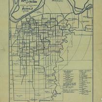
Title
-
Kansas City, Missouri Location and Boundaries of Schools
-
Description
-
Small map of Kansas City, Missouri, showing schools and school district boundaries and some streets. Includes a list of high schools and their boundaries. In lower right corner: "Arranged and traced by students in mechanical drafting, Central High School, K.C. Mo., vocational department."
-
Date
-
1915
-
Object Type
-
Map
-

-
Title
-
Kansas City Wards and Precincts
-
Description
-
Map of Kansas City south of the Missouri River, showing twenty divisions (probably wards), each with subdivisions (probably precincts).
-
Date
-
1954
-
Object Type
-
Map
-

-
Title
-
Kansas City, Missouri School Districts
-
Description
-
Street map of Kansas City showing grade school and high school district lines; locations of schools also shown.
-
Date
-
1948
-
Object Type
-
Map
-

-
Title
-
The Berry Company's Map of Kansas City
-
Description
-
Map of Kansas City, Missouri, indicating streets, hospitals, schools, and owners of land plots, south as far as 83rd St., east to just beyond the Blue River. Map cover includes post office hours, names and addresses of office buildings as well as city, county, and federal buildings, libraries and reading rooms, theaters, and parks.
-
Date
-
1912
-
Object Type
-
Map
-

-
Title
-
1931 Road Map of Jackson County, Missouri
-
Description
-
Map showing roads in Jackson County, Missouri. Legend indicates kind of road (macadam, graded, etc.). Section lines, electric lines, railroad lines, schools, and streams are also shown. Only a few major roads in Kansas City are identified. Shows townships and ranges.
-
Date
-
1931
-
Object Type
-
Map
-

-
Title
-
Johnson County, Kansas
-
Description
-
Land ownership map of Johnson County, Kansas, showing U.S highways, state highways, railroads, roads (paved, gravel and graded) political township boundaries, civil township lines, schools, churches, cemeteries, rivers, and streams. Includes the townships of Lexington, Monticello, Shawnee, Mission, Olathe, Oxford, McCamish, Gardner, Spring Hill, and Aubry.
-
Date
-
1930~
-
Object Type
-
Map
-
-
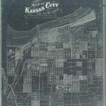
Title
-
Map of Kansas City and Suburbs
-
Description
-
Negative photocopy of a cadastral map showing plats in sections of the city.
-
Date
-
1877
-
Object Type
-
Map
Pages
