Pages
-

-
Title
-
Neighborhood Boundaries: Kansas City, Missouri
-
Description
-
Map depicts the then-boundaries of Kansas City, Missouri, and labels the 222 neighborhoods that the city encompasses. Streets and highways are illustrated when they constitute neighborhood borders, as are creeks and rivers.
-
Date
-
1983-10-14
-
Object Type
-
Map
-

-
Title
-
Polling Places in Kansas City
-
Description
-
Map shows wards and precincts; polling places are listed at bottom of page.
-
Date
-
1940-02-13
-
Object Type
-
Map
-

-
Title
-
Zoning Map, Kansas City, Missouri
-
Description
-
Kansas City, Missouri, color-coded zoning map of nine zone classifications, including residence, retail, and industrial zones. "Information taken from city ordinance No. 45608 and the latest official data of City Plan Commission."
-
Date
-
1923
-
Object Type
-
Map
-

-
Title
-
Polling Places in Kansas City, Missouri
-
Description
-
Map identifying various polling places within the school district boundaries of Kansas City, Missouri, including schools, fire stations, filling stations, and other sites.
-
Date
-
1929
-
Object Type
-
Map
-
-
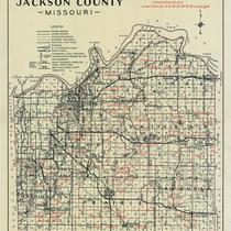
Title
-
Jackson County, Missouri
-
Description
-
Map shows roads, railroad lines, schools, and political township lines of Jackson County, Missouri, and also shows proposed enlarged school districts, with some school districts unchanged.
-
Date
-
1920
-
Object Type
-
Map
-

-
Title
-
Kansas City, Missouri
-
Description
-
Street map of Kansas City showing parks, cemeteries, park district boundaries, and street car lines. Handdrawn notations on map show changes in the city's boundaries since 1853. Notation compiled by R. Jenkins, Feb. 1925, suggests date of these ammendments.
-
Date
-
1915
-
Object Type
-
Map
-

-
Title
-
Kansas City, Missouri
-
Description
-
Street map of Kansas City showing parks, cemeteries, park district boundaries, and street car lines.
-
Date
-
1910
-
Object Type
-
Map
-

-
Title
-
Map of Adair County, Missouri
-
Description
-
Map of Adair County, Missouri, that includes schools, railroads, and churches. Includes the townships of Morrow, Nineveh, Polk, Clay, Benton, Liberty, Walnut, Pettis, Oklahoma, Wilson, West Salt River, and East Salt River. Also includes city of Kirksville.
-
Object Type
-
Map
-
-
Title
-
St. Clair County, Missouri (western half)
-
Description
-
Photocopy of St. Clair County, Missouri, plat map, western portion, including owners' names and showing rivers, railroads, and towns. Handwritten at bottom in ink: "Xerox copy from original plat book of St. Clair County, Missouri, c. 1900-03; original plat book in library of the Mo. State Historical Society. T38N RXXV West."
-
Date
-
1900~
-
Object Type
-
Map
-

-
Title
-
Kansas City, Missouri School Districts
-
Description
-
Map of Kansas City, south of the river, demarcates school district boundaries for the Kansas City, MO, Independence, Blue Springs, Raytown, Center, Hickman Mills, Grandview, and Lee's Summit school districts.
-
Date
-
1982-05-01
-
Object Type
-
Map
-

-
Title
-
Historical Kansas City
-
Description
-
General outline map with illustrations showing important dates and events in the history of Kansas City.
-
Date
-
1960
-
Object Type
-
Map
-

-
Title
-
School Board Elections Polling Places
-
Description
-
Page 5 from the January 17, 1972 edition of the Kansas City Star. Map shows wards and polling places.
-
Date
-
1972-01-17
-
Object Type
-
Map
-

-
Title
-
Texas County, Missouri
-
Description
-
Map of Texas County in Missouri showing townships, towns, section lines, roads, and railroads.
-
Date
-
1910~
-
Object Type
-
Map
-

-
Title
-
Topographical Map of Putnam County
-
Description
-
Topographical map of Putnam County, Missouri, that includes main traveled roads, wagon roads, railroads, rivers, streams, schools, churches, and cemeteries. Includes the townships of York, Sherman, Union, Lincoln, Liberty, Grant, Medicine, Jackson, Wilson, Richland, and Elm.
-
Date
-
1910~
-
Object Type
-
Map
-

-
Title
-
School District Election Polling Places
-
Description
-
Page 12 of the January 14, 1974 edition of the Kansas City Star. Map shows wards, school districts, and polling places.
-
Date
-
1974-01-14
-
Object Type
-
Map
-

-
Title
-
Polling Places in Kansas City
-
Description
-
Map shows wards and precincts; polling places are listed at bottom of page and continue onto a second page.
-
Date
-
1971-03-01
-
Object Type
-
Map
Pages
