Pages
-

-
Title
-
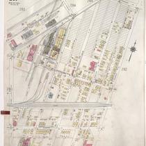
Sanborn Map, Kansas City, Vol. 2, 1940-1957, Page p281
-
Description
-
A portion of northeast Kansas City from Nicholson Avenue south to E. 1st Street and from N. Park Avenue east to N. Prospect Avenue, showing buildings, streets, and railroad lines. Large numbers at edges of pages refer to page with adjoining area.
-
Date
-
1940/1957
-
Object Type
-
Map
-
-
Title
-
Sanborn Map, Kansas City, Vol. 2, 1940-1950, Page p281
-
Description
-
A portion of northeast Kansas City from Nicholson Avenue south to E. 1st Street and from N. Park Avenue east to N. Prospect Avenue, showing buildings, streets, and railroad lines. Large numbers at edges of pages refer to page with adjoining area.
-
Date
-
1940/1950
-
Object Type
-
Map
-

-
Title
-
Sanborn Map, Kansas City, Vol. 2, 1940-1950, Page p280
-
Description
-
A portion of northeast Kansas City from E. Front Street south to Cliff Drive and from N. Woodland Avenue east to N. Park Avenue, showing buildings, parks, streets, and railroads. Large numbers at edges of pages refer to page with adjoining area.
-
Date
-
1940/1950
-
Object Type
-
Map
-

-
Title
-
Sanborn Map, Kansas City, Vol. 2, 1940-1950, Page p285
-
Description
-
Portions of northeast Kansas City in the Missouri Pacific Railroad Company's railyards and the General Mills Incorporated plant. Large numbers at edges of pages refer to page with adjoining area.
-
Date
-
1940/1950
-
Object Type
-
Map
-

-
Title
-
Sanborn Map, Kansas City, Vol. 2, 1940-1950, Page p279
-
Description
-
A portion of northeast Kansas City from E. Front Street south to Cliff Drive and from Lydia Avenue east to N. Woodland Avenue, showing buildings, parks, streets, and railroad lines. Large numbers at edges of pages refer to page with adjoining area.
-
Date
-
1940/1950
-
Object Type
-
Map
-

-
Title
-
Sanborn Map, Kansas City, Vol. 2, 1909-1937, Page p151
-
Description
-
A portion of Kansas City Old Town from E. 1st Street south to E. 3rd Street and from Main Street east to Grand Avenue, showing buildings, streets, railroads, and additions. Large numbers at edges of page refer to page with adjoining area. Volume begins with sheet 151.
-
Date
-
1909/1937
-
Object Type
-
Map
-

-
Title
-
Sanborn Map, Kansas City, Vol. 2, 1940-1957, Page p282
-
Description
-
A portion of northeast Kansas City from Nicholson Avenue south to Guinotte Avenue and from N. Prospect Avenue east to N. Walrond Avenue, showing buildings, parks, streets, and railroad lines. Large numbers at edges of pages refer to page with adjoining area.
-
Date
-
1940/1957
-
Object Type
-
Map
-

-
Title
-
Sanborn Map, Kansas City, Vol. 2, 1940-1957, Page p280
-
Description
-
A portion of northeast Kansas City from E. Front Street south to Cliff Drive and from N. Woodland Avenue east to N. Park Avenue, showing buildings, parks, streets, and railroads. Large numbers at edges of pages refer to page with adjoining area.
-
Date
-
1940/1957
-
Object Type
-
Map
-

-
Title
-
Sanborn Map, Kansas City, Vol. 5, 1909-1938, Page p606
-
Description
-
A portion of Kansas City from Rochester Avenue south to Guinotte Avenue and from N. Park Avenue east to N. Wabash Avenue, showing buildings, streets, railroads, and additions. Large numbers at edges of page refer to page with adjoining area.
-
Date
-
1909/1938
-
Object Type
-
Map
-

-
Title
-
Sanborn Map, Kansas City, Vol. 5, 1909-1938, Page p614
-
Description
-
A portion of Kansas City at the intersection of N. Monroe Avenue and Nicholson Avenue, showing the W. S. Dickey Clay Manufacturing Company and Missouri Pacific Railroad roundhouse. Large numbers at edges of page refer to page with adjoining area.
-
Date
-
1909/1938
-
Object Type
-
Map
-

-
Title
-
Sanborn Map, Kansas City, Vol. 5, 1909-1938, Page p702
-
Description
-
A portion of Kansas City from E. 16th Street south to E. 17th Street and from Eastern Avenue east to Palmer Avenue, showing buildings, streets, railroads, and additions. Large numbers at edges of page refer to page with adjoining area.
-
Date
-
1909/1938
-
Object Type
-
Map
-

-
Title
-
Sanborn Map, Kansas City, Vol. 5, 1909-1938, Page p609
-
Description
-
A portion of Kansas City from E. Front Street south to Heim Avenue and from N. Brooklyn Avenue east to N. Olive, showing buildings, streets, railroads, and additions. Large numbers at edges of page refer to page with adjoining area.
-
Date
-
1909/1938
-
Object Type
-
Map
-

-
Title
-
Sanborn Map, Kansas City, Vol. 5, 1909-1938, Page p602
-
Description
-
A portion of Kansas City from E. Front Street south to E. 1st Street and from Lydia Avenue east to N. Vine, showing buildings, streets, railroads, and additions. Large numbers at edges of page refer to page with adjoining area.
-
Date
-
1909/1938
-
Object Type
-
Map
-

-
Title
-
Sanborn Map, Kansas City, Vol. 5, 1909-1938, Page p601
-
Description
-
A portion of Kansas City from E. Front Street south to E. 1st Street and from Troost Avenue east to Lydia Avenue, showing buildings, streets, railroads, and additions. Large numbers at edges of page refer to page with adjoining area.
-
Date
-
1909/1938
-
Object Type
-
Map
-

-
Title
-
Sanborn Map, Kansas City, Vol. 5, 1909-1938, Page p708
-
Description
-
A portion of Kansas City at the intersection of Independence Avenue and Northern Boulevard, showing buildings, streets, railroads, and additions. Large numbers at edges of page refer to page with adjoining area. At the top of page, "Located on S. half of Sec. 33, 7 1/2 miles E. of P. O."
-
Date
-
1909/1938
-
Object Type
-
Map
-

-
Title
-
Sanborn Map, Kansas City, Vol. 1, 1909-1938, Page p001
-
Description
-
A portion of Kansas City from W. 5th Street south to W. 7th Street and from Woodswether Road east to Pennsylvania Avenue, showing buildings, streets, and railroads. Large numbers at edges of page refer to page with adjoining area.
-
Date
-
1909/1938
-
Object Type
-
Map
-

-
Title
-
Sanborn Map, Kansas City, Vol. 1, 1909-1938, Page p026
-
Description
-
A portion of Kansas City from W. 9th Street south to W. 11th Street and from Wyoming east to Hickory, showing buildings, streets, railroads, and additions. Large numbers at edges of page refer to page with adjoining area.
-
Date
-
1909/1938
-
Object Type
-
Map
-

-
Title
-
Sanborn Map, Kansas City, Vol. 1, 1909-1938, Page p002
-
Description
-
A portion of Kansas City from W. 3rd Street south to W. 5th Street and from Bluff Street east to Broadway, showing buildings, streets, railroads, and additions. Large numbers at edges of page refer to page with adjoining area.
-
Date
-
1909/1938
-
Object Type
-
Map
-

-
Title
-
Sanborn Map, Kansas City, Vol. 1, 1909-1938, Page p025
-
Description
-
A portion of Kansas City from W. 9th Street south to Saint Louis Avenue and from S. State Line east to Wyoming, showing buildings, streets, and additions. Large numbers at edges of page refer to page with adjoining area.
-
Date
-
1909/1938
-
Object Type
-
Map
-

-
Title
-
Sanborn Map, Kansas City, Vol. 1, 1939-1958, Page p043
-
Description
-
A portion of Kansas City from W. 1st Street south to W. 3rd Street and from Broadway east to Wyandotte, showing buildings and streets. Large numbers at edges of page refer to page with adjoining area.
-
Date
-
1939/1958
-
Object Type
-
Map
Pages
