Pages
-

-
Title
-
United States
-
Description
-
Map of the United States showing Arkansas Territory, Missouri Territory (stretching to the west coast), and a large area comprising the southwest, including present-day northern Mexico. Names of many Indian tribes, and some Indian villages, appear on this map, as well as towns and rivers. The state of Missouri is shown as stretching well into present-day Iowa.
-
Date
-
1822
-
Object Type
-
Map
-

-
Title
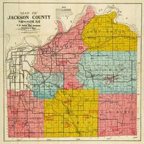
-
Historic Jackson County, MO
-
Description
-
Hand-drawn map of Jackson County, Missouri showing historic and contemporary roads, historic boundaries, townships and ranges, bodies of water, homes, churches, cemeteries, missions, battles, forts, schools, mills, camps, and Indian reservations. Cities, towns, and villages are also depicted. Map also includes historic information regarding the creation of townships in Jackson County, and factual information about the county.
-
Date
-
1944
-
Object Type
-
Map
-

-
Title
-
A New Map of the State of Iowa
-
Description
-
Map showing all four boundaries of the state of Iowa. Includes all of the counties in the state and portions of Nebraska, Missouri, Minnesota, and Illinois. Number "35" printed on the lower right corner.
-
Date
-
1856
-
Object Type
-
Map
-

-
Title
-
Missouri Waltzes to New Bed
-
Description
-
Illustrated map and article about the shifting of the Missouri River (partly from flooding and partly engineered by the United States Army Corps of Engineers) between Saint Joseph, Missouri (about 50 miles north of Kansas City), and Elwood, Kansas, and cutting off "Rosecrans Field, St. Joseph's airport and former Air Force base," in a change of state boundary lines, etc.
-
Date
-
1952-07-12
-
Object Type
-
Magazine Article
-

-
Title
-
Diagram of the State of Missouri
-
Description
-
Map of Missouri marked off into blocks of land, each six miles square, known as townships. Symbols indicate whether or not the townships have been subdivided by surveyors. Names of contracted surveyors may be found in the text accompanying map. Lead, iron, copper, and coal mines are indicated, as well as salt works. Watersheds shown in detail. Survey of the southern boundary of the state is given extra attention, as is the old Indian boundary line commonly called Sullivan's line on the north. Fourth in a series of four maps showing the progress of surveys in Missouri.
-
Date
-
1851
-
Object Type
-
Map
-

-
Title
-
Iowa
-
Description
-
Map of Iowa showing all four bondaries of the state. Includes counties and portions of Minnesota, Nebraska, Missouri, Illinois, and Wisconsin. "No. 47" is printed on the lower right corner.
-
Date
-
1855
-
Object Type
-
Map
-

-
Title
-
Colton's New Map of Missouri
-
Description
-
Continuation of title: "Compiled from the U.S. Surveys, and other authentic sources." Map of Missouri with counties shown in color with township and range lines. Also shows towns, roads, canals, mills, mines, and railroads finished and proposed. Some towns and Indian territory indicated for eastern Kansas.
-
Date
-
1857
-
Object Type
-
Map
-

-
Title
-
1922 Road Map of Jackson County, Missouri
-
Description
-
Map showing roads in Jackson County, Missouri. Legend indicates type of road (macadam, graded, etc.). Section lines, electric lines, railroad lines, and streams are also shown. Only a few major roads in Kansas City are identified.
-
Date
-
1922
-
Object Type
-
Map
-
-
Title
-
Map of Jackson County, Missouri
-
Description
-
Map of Jackson County, Missouri, depicting roads (graded, rock, county), railroads, streams, schools, and churches. Includes townships of Blue, Brooking, Washington, Prairie, Van Buren, Sni-a-bar, and Fort Osage, and cities of Kansas City and Independence. Also includes major farms: Walton-Holmes, Minor, F. G. Robinson, Belvedere, W. D. Johnson, Longview, Malvern Land Co., Blackwell, Barzen, J. C. Knopp, Alexander, King, La Cima, Fields, Yost, Velie, Sni-a-bar, Andrew Drumm, Swinney, and McCoy.
-
Date
-
1917
-
Object Type
-
Map
-

-
Title
-
Map of Johnson County, Kansas
-
Description
-
Land ownership map of Johnson County, Kansas, showing railroads, electric lines, public roads, rock roads, school districts, streams, churches, and cemeteries, as well as oil, gas, drilling, dry, and abandoned wells. Includes the townships of Lexington, Monticello, Shawnee, Mission, Olathe, Oxford, McCamish, Gardner, Spring Hill, and Aubry. The names "checked by Frank Norman, bonded abstractor, Olathe, Kansas."
-
Date
-
1912
-
Object Type
-
Map
-
-
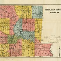
Title
-
Livingston County, Missouri
-
Description
-
Map of Livingston County, Missouri, depicting roads, auto roads, schools, churches, cemeteries, railroads, and streams. Includes townships of Jackson, Cream Ridge, Medicine, Sampsell, Chillicothe, Rich Hill, Wheeling, Moores, Green, Monroe, Blue Mound, Fairview, and Grand River. Includes city of Chillicothe.
-
Object Type
-
Map
-

-
Title
-
Map of Ray CO. MO.
-
Description
-
Map of Ray County, Missouri, that includes roads, towns, churches, schools, and railroads. Includes townships of Polk, Knoxville, Grape Grove, Fishing River, Richmond, Crooked River, Orrick, and Cadem. Also shows city of Richmond, Missouri. Handwritten notes indicate roads continuing to towns off the map.
-
Object Type
-
Map
-

-
Title
-
Map of the State of Iowa
-
Description
-
Map showing all four boundaries of the state of Iowa and fifty counties located in the east and south sections of the state. Adjacent portions of Wisconsin, Illinois, Missouri, Indian Territory, and Minnesota also shown.
-
Date
-
1850
-
Object Type
-
Map
-

-
Title
-
The Disappearing Boundaries
-
Description
-
Description of the Citizens Regional Planning Council of Greater Kansas City, covering two states, five counties, and numerous cities in the Kansas City metropolitan area.
-
Date
-
1946-05
-
Object Type
-
Magazine Article
-

-
Title
-
History of the State of Kansas
-
Description
-
Portrait and biographical sketch of John Johnson, "the pioneer settler and banker of Highland, Doniphan County, Kan.," in 1854. Description of his life and career. He was born in 1817 in Illinois and became a surveyor and Kansas state representative, and real estate developer, as well as establisher of "the boundary line between the two new territories of Kansas and Nebraska" in 1854.
-
Date
-
1883
-
Object Type
-
Book
-

-
Title
-
The Establishment of Counties in Kansas
-
Description
-
Maps and thesis toward a master's degree for the University of Kansas about the establishment of counties in Kansas starting with the "first territorial legislature" in 1855 Kansas Territory.
-
Date
-
1904
-
Object Type
-
Magazine Article
-

-
Title
-
Colton's New Sectional Map of the State of Missouri
-
Description
-
Continuation of title: Compiled from the United States Surveys and Other Authentic Sources Exhibiting the Sections, Fractional Sections, Counties, Cities, Towns, Villages, Post Offices, Rail Roads & other Internal Improvements. Map of Missouri with counties shown in color with township and range lines. Also shows towns, roads, canals, mills, mines, and railroads finished and proposed. Some towns and Indian territory indicated for eastern Kansas.
-
Date
-
1872
-
Object Type
-
Map
Pages

