Pages
-

-
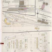
Title
-
Sanborn Map, Kansas City, Vol. 1A, 1939-1949, Page p178
-
Description
-
A portion of Kansas City from W. 9th Street south to Union Avenue and from Mulberry east to Santa Fe, showing buildings, railroads and streets. Large numbers at edges of page refer to page with adjoining area.
-
Date
-
1939/1949
-
Object Type
-
Map
-

-
Title
-
Sanborn Map, Kansas City, Vol. 5, 1940-1941, Page p0614
-
Description
-
A portion of Kansas City from E. 6th Street south to E. 12th Street and from Winchester Avenue east to Eastern Avenue, showing buildings, railroads, and streets. Large numbers at edges of page refer to page with adjoining area. Indicated at top of sheet that this page number corresponds with pages 696, 699, 703, and 709 in Vol. 5, 1909-1938.
-
Date
-
1940/1941
-
Object Type
-
Map
-
-
Title
-
Sanborn Map, Kansas City, Vol. 5, 1940-1941, Page p0635
-
Description
-
A portion of Kansas City from Gladstone Boulevard south to Norledge Avenue and from Elmwood Avenue east to N. Quincy Avenue, showing buildings, railroads, and streets. Large numbers at edges of page refer to page with adjoining area. Indicated at top of sheet that this page number corresponds with page 613 and 615 in Vol. 5, 1909-1938.
-
Date
-
1940/1941
-
Object Type
-
Map
-

-
Title
-
Sanborn Map, Kansas City, Vol. 1, 1909-1938, Page p027
-
Description
-
A portion of Kansas City from W. 9th Street south to W. 11th Street and from Hickory east to Mulberry, showing buildings, streets, railroads and additions. Large numbers at edges of page refer to page with adjoining area.
-
Date
-
1909/1938
-
Object Type
-
Map
-

-
Title
-
Sanborn Map, Kansas City, Vol. 5, 1909-1938, Page p698
-
Description
-
A portion of Kansas City from E. 13th Street south to E. 16th Street and from Bristol Avenue east to Eastern Avenue, showing buildings, streets, railroads, and additions. Large numbers at edges of page refer to page with adjoining area.
-
Date
-
1909/1938
-
Object Type
-
Map
-

-
Title
-
Sanborn Map, Kansas City, Vol. 5, 1909-1938, Page p700
-
Description
-
A portion of Kansas City from E. 16th Street south to E. 17th Street and from Bristol Avenue east to Eastern Avenue, showing buildings, streets, railroads, and additions. Large numbers at edges of page refer to page with adjoining area.
-
Date
-
1909/1938
-
Object Type
-
Map
-

-
Title
-
Sanborn Map, Kansas City, Vol. 5, 1909-1938, Page p696
-
Description
-
A portion of Kansas City from E. 11th Street south to E. 13th Street and from Winchester Avenue east to Crystal Avenue, showing buildings, streets, and additions. Large numbers at edges of page refer to page with adjoining area.
-
Date
-
1909/1938
-
Object Type
-
Map
-

-
Title
-
Sanborn Map, Kansas City, Vol. 1, 1909-1938, Page p003
-
Description
-
A portion of Kansas City from W. Front south to W. 3rd Street and from Broadway east to Wyandotte, showing buildings, streets, railroads, and additions. Large numbers at edges of page refer to page with adjoining area.
-
Date
-
1909/1938
-
Object Type
-
Map
-

-
Title
-
Sanborn Map, Kansas City, Vol. 1, 1939-1958, Page p045
-
Description
-
A portion of Kansas City from W. Front Street south to W. 2nd Street and from Main Street east to Gillis, showing buildings and streets. Large numbers at edges of page refer to page with adjoining area.
-
Date
-
1939/1958
-
Object Type
-
Map
-

-
Title
-
Sanborn Map, Kansas City, Vol. 1, 1939-1958, Page p044
-
Description
-
A portion of Kansas City from W. 1st Street south to W. 3rd Street and from Wyandotte east to Main, showing buildings and streets. Large numbers at edges of page refer to page with adjoining area.
-
Date
-
1939/1958
-
Object Type
-
Map
-

-
Title
-
Sanborn Map, Kansas City, Vol. 1, 1939-1958, Page p046
-
Description
-
A portion of Kansas City from Front Street south to E. 5th Street and from Gillis east to Lydia, showing buildings and streets. Large numbers at edges of page refer to page with adjoining area.
-
Date
-
1939/1958
-
Object Type
-
Map
-

-
Title
-
Bates CO. Missouri
-
Description
-
Map of Bates County, Missouri, that includes paved roads, graveled roads, state or county roads not highly improved, roads, interstates and highways, railroads, drainage district line, municipal township lines, streams, and schools. Includes the townships of West Boone, East Boone, Deer Creek, Grand River, Mingo, West Point, Elkhart, Mound, Shawnee, Spruce, Homer, Charlotte, Mount Pleasant, Summit, Deepwater, Walnut, New Home, Lone Oak, Pleasant Gap, Hudson, Howard, Osage, Prairie, and Rockville.
-
Object Type
-
Map
-
-
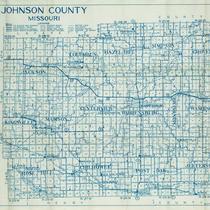
Title
-
Johnson County, Missouri
-
Description
-
Map of Johnson County, Missouri, that includes highways, county roads, township roads, political township lines, railroads, drainage ditches, streams, and schools. Included are townships Jackson, Columbus, Hazel Hill, Simpson, Grover, Kingsville, Madison, Centerview, Warrensburg, Washington, Montserrat, Rose Hill, Chilhowee, Post Oak, and Jefferson.
-
Object Type
-
Map
-

-
Title
-
Sanborn Map, Kansas City, Vol. 3, 1896-1907, Page p350
-
Description
-
Northeastern part of early Kansas City near Independence, Missouri, in the industrial areas along the rail lines, showing buildings, streets, and railroad lines. Large numbers at edges of page refer to page with adjoining area.
-
Date
-
1896/1907
-
Object Type
-
Map
-

-
Title
-
Sanborn Map, Kansas City, Vol. 2, 1896-1907, Page p219
-
Description
-
Northeastern part of early Kansas City from about Guinotte Avenue south to about Saint John Avenue and from Lexington Avenue east to Highland Avenue, showing buildings, streets, and railroad lines. Large numbers at edges of page refer to page with adjoining area.
-
Date
-
1896/1907
-
Object Type
-
Map
-
-
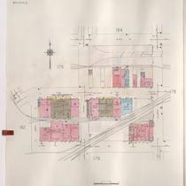
Title
-
Sanborn Map, Kansas City, Vol. 1A, 1939-1957, Page p177
-
Description
-
A portion of Kansas City from W. 9th Street south to Union Avenue and from Liberty east to Mulberry, showing buildings, railroads, and streets. Large numbers at edges of page refer to page with adjoining area.
-
Date
-
1939/1957
-
Object Type
-
Map
-

-
Title
-
Sanborn Map, Kansas City, Vol. 1, 1895-1907, Page p011
-
Description
-
Northern edge of early Kansas City. Quality Hill area showing buildings, railroad lines, and streets. Large numbers at edges of page refer to page showing adjoining area.
-
Date
-
1895/1907
-
Object Type
-
Map
-

-
Title
-
Sanborn Map, Kansas City, Vol. 1, 1895-1907, Page p002
-
Description
-
Northern boundary (Missouri River) of Kansas City Old Town showing streets, buildings, railroad lines, and bridges. Large numbers at edge of page refer to page number with adjoining area.
-
Date
-
1895/1907
-
Object Type
-
Map
-

-
Title
-
Sanborn Map, Kansas City, Vol. 1, 1895-1907, Page p003
-
Description
-
Northern edge of early Kansas City. Riverfront area shows buildings, railroad lines, and streets. Large numbers at edge of page refer to page number or volume with adjoining area.
-
Date
-
1895/1907
-
Object Type
-
Map
-

-
Title
-
Sanborn Map, Kansas City, Vol. 1, 1895-1907, Page p013
-
Description
-
Northern part of early Kansas City in the West Bottoms from W. 8th Street south to Union Avenue and from Santa Fe Street east to Lincoln Street. Large numbers on the edges of page refer to page with adjoining area.
-
Date
-
1895/1907
-
Object Type
-
Map
Pages
