Pages
-

-
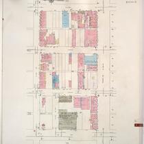
Title
-
Sanborn Map, Kansas City, Vol. 2, 1909-1937, Page p229
-
Description
-
A portion of Kansas City from E. 11th Street south to E. 13th Street and from Oak Street east to Cherry Street, showing buildings, streets, and additions. Large numbers at edges of page refer to page with adjoining area.
-
Date
-
1909/1937
-
Object Type
-
Map
-

-
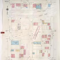
Title
-
Sanborn Map, Kansas City, Vol. 2, 1909-1937, Page p213
-
Description
-
A portion of Kansas City from E. 8th Street south to E. 11th Street and from Holmes east to Campbell, showing buildings, streets, and additions. Large numbers at edges of page refer to page with adjoining area.
-
Date
-
1909/1937
-
Object Type
-
Map
-

-
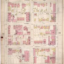
Title
-
Sanborn Map, Kansas City, Vol. 2, 1909-1937, Page p231
-
Description
-
A portion of Kansas City from E. 11th Street south to E. 13th Street and from Charlotte Street east to Harrison Street, showing buildings, streets, and additions. Large numbers at edges of page refer to page with adjoining area.
-
Date
-
1909/1937
-
Object Type
-
Map
-

-
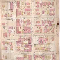
Title
-
Sanborn Map, Kansas City, Vol. 2, 1909-1937, Page p232
-
Description
-
A portion of Kansas City from E. 11th Street south to E. 13th Street and from Harrison Street east to Forest Avenue, showing buildings, streets, and additions. Large numbers at edges of page refer to page with adjoining area.
-
Date
-
1909/1937
-
Object Type
-
Map
-

-
Title
-
Sanborn Map, Kansas City, Vol. 2, 1909-1937, Page p196
-
Description
-
A portion of Kansas City from Independence Avenue south to E. 8th Street and from Holmes east to Campbell, showing buildings, streets, and additions. Large numbers at edges of page refer to page with adjoining area.
-
Date
-
1909/1937
-
Object Type
-
Map
-

-
Title
-
Sanborn Map, Kansas City, Vol. 2, 1909-1937, Page p195
-
Description
-
A portion of Kansas City from Independence Avenue south to E. 8th Street and from Oak Street east to Cherry Street, showing buildings, streets and additions. Includes school district equipment storage buildings. Large numbers at edges of page refer to page with adjoining area.
-
Date
-
1909/1937
-
Object Type
-
Map
-

-
Title
-
Sanborn Map, Kansas City, Vol. 2, 1909-1937, Page p212
-
Description
-
A portion of Kansas City from E. 8th Street south to E. 11th Street and from Oak Street east to Holmes Street, showing buildings, streets, and additions. Large numbers at edges of page refer to page with adjoining area.
-
Date
-
1909/1937
-
Object Type
-
Map
-

-
Title
-
Sanborn Map, Kansas City, Vol. 2, 1909-1937, Page p244
-
Description
-
A portion of Kansas City from E. 13th Street south to E. 15th Street and from Holmes Street east to Campbell, showing buildings, streets, and additions. Large numbers at edges of page refer to page with adjoining area.
-
Date
-
1909/1937
-
Object Type
-
Map
-

-
Title
-
Sanborn Map, Kansas City, Vol. 1, 1939-1958, Page p066
-
Description
-
A portion of Kansas City from Independence Avenue south to E. 8th Street and from Cherry east to Charlotte, showing buildings and streets. Large numbers at edges of page refer to page with adjoining area.
-
Date
-
1939/1958
-
Object Type
-
Map
-

-
Title
-
Sanborn Map, Kansas City, Vol. 1, 1939-1958, Page p012
-
Description
-
A portion of Kansas City from E. 8th Street south to E. 10th Street and from Locust east to Holmes, showing buildings and streets. Large numbers at edges of page refer to page with adjoining area.
-
Date
-
1939/1958
-
Object Type
-
Map
-

-
Title
-
Sanborn Map, Kansas City, Vol. 1, 1939-1958, Page p024
-
Description
-
A portion of Kansas City from E. 10th Street south to E. 12th Street and from Locust east to Holmes, showing buildings and streets. Large numbers at edges of page refer to page with adjoining area.
-
Date
-
1939/1958
-
Object Type
-
Map
-

-
Title
-
Sanborn Map, Kansas City, Vol. 1, 1939-1958, Page p022
-
Description
-
A portion of Kansas City from E. 9th Street south to E. 11th Street and from McGee east to Oak, showing buildings and streets. Large numbers at edges of page refer to page with adjoining area.
-
Date
-
1939/1958
-
Object Type
-
Map
-
-
Title
-
Sanborn Map, Kansas City, Vol. 1, 1939-1958, Page p086
-
Description
-
A portion of Kansas City from E. 14th Street south to Truman Road and from Oak Street east to Holmes, showing buildings and streets. Large numbers at edges of page refer to page with adjoining area.
-
Date
-
1939/1958
-
Object Type
-
Map
-

-
Title
-
Sanborn Map, Kansas City, Vol. 1, 1939-1958, Page p079
-
Description
-
A portion of Kansas City from E. 12th Street south to E. 14th Street and from Holmes Street east to Campbell Street, showing buildings and streets. Large numbers at edges of page refer to page with adjoining area.
-
Date
-
1939/1958
-
Object Type
-
Map
-

-
Title
-
Sanborn Map, Kansas City, Vol. 1, 1939-1958, Page p075
-
Description
-
A portion of Kansas City from E. 10th Street south to E. 12th Street and from Holmes Street east to Campbell, showing buildings and streets. Large numbers at edges of page refer to page with adjoining area.
-
Date
-
1939/1958
-
Object Type
-
Map
-
-
Title
-
Sanborn Map, Kansas City, Vol. 1, 1939-1958, Page p067
-
Description
-
A portion of Kansas City from Independence Avenue south to E. 8th Street and from Charlotte east to Harrison, showing buildings and streets. Large numbers at edges of page refer to page with adjoining area.
-
Date
-
1939/1958
-
Object Type
-
Map
-

-
Title
-
Sanborn Map, Kansas City, Vol. 1, 1939-1958, Page p071
-
Description
-
A portion of Kansas City from E. 8th Street south to E. 10th Street and from Holmes Street east to Campbell Street, showing buildings and streets. Large numbers at edges of page refer to page with adjoining area.
-
Date
-
1939/1958
-
Object Type
-
Map
-

-
Title
-
Sanborn Map, Kansas City, Vol. 2, 1896-1907, Page p133
-
Description
-
Northeastern part of early Kansas City from Independence Avenue south to Admiral Boulevard and from Holmes Street east to Harrison Street, showing buildings, streets, and additions. Large numbers at edges of page refer to page with adjoining area.
-
Date
-
1896/1907
-
Object Type
-
Map
-
-
Title
-
Sanborn Map, Kansas City, Vol. 2, 1896-1907, Page p135
-
Description
-
Northeastern part of early Kansas City from E. 10th Street south to E. 12th Street and from Holmes Street east to Harrison Street, showing buildings, streets, and additions. Large numbers at edges of page refer to page with adjoining area.
-
Date
-
1896/1907
-
Object Type
-
Map
-
-
Title
-
Sanborn Map, Kansas City, Vol. 2, 1896-1907, Page p124
-
Description
-
Northeastern part of early Kansas City from E. 8th Street south to E. 10th Street and from Oak Street east to Holmes Street, showing buildings, streets, and additions. Large numbers at edges of page refer to page with adjoining area.
-
Date
-
1896/1907
-
Object Type
-
Map
Pages
