-
-
Title
-
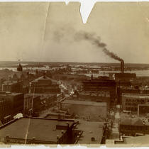
Flood Scene
-
Description
-
View looking north along Walnut Street from 6th Street during a 1908 flood. The Missouri River can be seen in the distance. Several downtown buildings are in view. Signs for the New Nelson building, the Henry House hotel, and the Clay Auction Company can be seen.
-
Date
-
1908
-
Object Type
-
Photograph
-
-
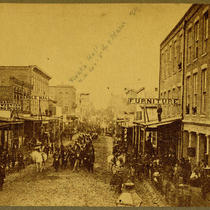
Title
-
Looking North on Main from 6th and Missouri Avenue
-
Description
-
View looking north along Main Street from 6th Street and Missouri Avenue. Handwritten on the image is Frank's Hall at the northwest corner of 5th and Main streets. Signs for Baum and Brothers Clothing, the Marble Hall, and Bullene Brothers and Emery Dry Goods can be seen. The street is crowded with pedestrians and a parade is moving down the street.
-
Date
-
1869-08
-
Object Type
-
Photograph
-
-
Title
-
Thurman's Livery - 6th and Delaware
-
Description
-
View of Thurman's Livery, once located at the northeast corner of 6th and Delaware streets. Several early downtown buildings and houses can be seen. A sign for Excelsior Stable is in view.
-
Date
-
1869
-
Object Type
-
Photograph
-
-
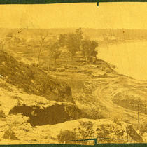
Title
-
Looking South on Bluff Street from 6th
-
Description
-
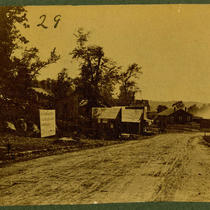
View looking south along Bluff Street into the West Bottoms from 6th Street. Early downtown houses can be seen.
-
Date
-
1870~
-
Object Type
-
Photograph
-

-
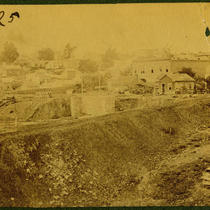
Title
-
Walnut between 6th and 8th
-
Description
-
View of Walnut Street between 6th and 8th streets during construction Several individuals and a horse drawn cart around the site can be seen.
-
Date
-
1870~
-
Object Type
-
Photograph
-
-
Title
-
Sanborn Map, Kansas City, Vol. 3, 1896-1907, Page p358
-
Description
-
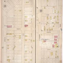
Northern part of early Kansas City in the Birmingham industrial district, from 4th Street south to 5th Street and from Spratley Avenue east to Clay Street, as well as a portion of Minnaville, Missouri, showing buildings and streets. Large numbers at edges of page refer to page with adjoining area. At top of map, "Birmingham, Clay County, Mo., situated 10 miles n.e. of Kansas City, Mo."
-
Date
-
1896/1907
-
Object Type
-
Map
-
-
Title
-
Muehlebach Brewery
-
Description
-
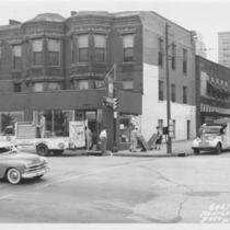
Muehlebach Brewery trucks delivering goods to Grand Slam Liquor Store, located at 201 E. 6th Street Trafficway.
-
Date
-
1950
-
Object Type
-
Photograph
-

-
Title
-
Dr. T. B. Lester's Residence at 6th and Walnut
-
Description
-
View of Dr. Thomas B. Lester's residence, once located at 6th and Walnut streets. Several early downtown buildings and houses can be seen. A handwritten note on the image indicates the path of Walnut Street.
-
Date
-
1868
-
Object Type
-
Photograph
-
-
Title
-
Sixth Street Trafficway - Paseo Bridge Approach
-
Description
-
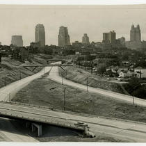
Elevated view looking southwest of the northeast corner of the downtown expressway look where 6th Street Trafficway meets the Paseo Bridge approach. The downtown skyline can be seen in the background. Cars traveling along the streets can be seen. A portion of the Columbus Park neighborhood is in view on the right hand side of the image.
-
Date
-
1954-10
-
Object Type
-
Photograph