Pages
-

-
Title
-
St. Mary's Episcopal Church and Surroundings
-
Description
-
Elevated view looking east taken from atop the Jackson County Courthouse showing the area surrounding St. Mary's Episcopal Church. Several parked cars can be seen. Construction of the southeast corner of the downtown expressway loop is in view.
-
Date
-
1960-05
-
Object Type
-
Photograph
-

-
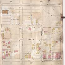
Title
-
Sanborn Map, Kansas City, Vol. 3, 1909-1957, Page p395
-
Description
-
A portion of Kansas City from E. 28th Street south to E. 29th Street and from Cherry Street east to Campbell Street, showing buildings, streets, and additions. Large numbers at edges of page refer to page with adjoining area.
-
Date
-
1909/1957
-
Object Type
-
Map
-

-
Title
-
Sanborn Map, Kansas City, Vol. 2, 1909-1937, Page p154
-
Description
-
A portion of Kansas City from Front Street south to E. 2nd Street and from Charlotte east to Harrison, showing buildings, streets, railroads, and additions. Large numbers at edges of page refer to page with adjoining area.
-
Date
-
1909/1937
-
Object Type
-
Map
-
-
Title
-
Sanborn Map, Kansas City, Vol. 2, 1909-1937, Page p160
-
Description
-
A portion of Kansas City from E. 2nd Street south to E. 5th Street and from Holmes east to Harrison, showing buildings, streets, railroads, and additions. Large numbers at edges of page refer to page with adjoining area.
-
Date
-
1909/1937
-
Object Type
-
Map
-

-
Title
-
Sanborn Map, Kansas City, Vol. 2, 1909-1937, Page p172
-
Description
-
A portion of Kansas City from E. 5th Street south to Independence Avenue and from Holmes east to Harrison, showing buildings, streets, and additions. Large numbers at edges of page refer to page with adjoining area.
-
Date
-
1909/1937
-
Object Type
-
Map
-

-
Title
-
Sanborn Map, Kansas City, Vol. 2, 1909-1937, Page p153
-
Description
-
A portion of Kansas City Old Town from E. 1st Street south to E. 2nd Street and from Cherry Street east to Charlotte, showing buildings, streets, railroads, and additions. Large numbers at edges of page refer to page with adjoining area.
-
Date
-
1909/1937
-
Object Type
-
Map
-

-
Title
-
Sanborn Map, Kansas City, Vol. 2, 1909-1937, Page p213
-
Description
-
A portion of Kansas City from E. 8th Street south to E. 11th Street and from Holmes east to Campbell, showing buildings, streets, and additions. Large numbers at edges of page refer to page with adjoining area.
-
Date
-
1909/1937
-
Object Type
-
Map
-

-
Title
-
Sanborn Map, Kansas City, Vol. 2, 1909-1937, Page p231
-
Description
-
A portion of Kansas City from E. 11th Street south to E. 13th Street and from Charlotte Street east to Harrison Street, showing buildings, streets, and additions. Large numbers at edges of page refer to page with adjoining area.
-
Date
-
1909/1937
-
Object Type
-
Map
-

-
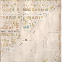
Title
-
Sanborn Map, Kansas City, Vol. 3, 1909-1957, Page p316
-
Description
-
A portion of Kansas City from E. 17th Street south to E. 19th Street and from Charlotte east to Harrison, showing buildings, streets, and additions. Large numbers at edges of page refer to page with adjoining area.
-
Date
-
1909/1957
-
Object Type
-
Map
-

-
Title
-
Sanborn Map, Kansas City, Vol. 4, 1909-1950, Page p480
-
Description
-
A portion of Kansas City from E. 34th Street south to E. 36th Street and from Holmes Avenue east to Harrison Boulevard, showing buildings, streets, and additions. Large numbers at edges of page refer to page with adjoining area.
-
Date
-
1909/1950
-
Object Type
-
Map
-

-
Title
-
Sanborn Map, Kansas City, Vol. 3, 1909-1957, Page p396
-
Description
-
A portion of Kansas City from E. 30th Street south to E. 31st Street and from McGee Street Trafficway east to Campbell Street, showing buildings, streets, and additions. Large numbers at edges of page refer to page with adjoining area.
-
Date
-
1909/1957
-
Object Type
-
Map
-

-
Title
-
Sanborn Map, Kansas City, Vol. 3, 1909-1957, Page p330
-
Description
-
A portion of Kansas City from E. 19th Street south to E. 21st Street and from Charlotte east to Harrison, showing buildings, streets, and additions. Large numbers at edges of page refer to page with adjoining area.
-
Date
-
1909/1957
-
Object Type
-
Map
-

-
Title
-
Sanborn Map, Kansas City, Vol. 4, 1909-1950, Page p463
-
Description
-
A portion of Kansas City from E. 31st Street south to E. Linwood Boulevard and from Gillham Road east to Campbell Street, showing buildings, streets, and additions. Large numbers at edges of page refer to page with adjoining area.
-
Date
-
1909/1950
-
Object Type
-
Map
-
-
Title
-
Sanborn Map, Kansas City, Vol. 4, 1909-1950, Page p540
-
Description
-
A portion of Kansas City from E. 44th Street south to E. 45th Street and from Kenwood Avenue east to Harrison Street, showing buildings, streets, and additions. Large numbers at edges of page refer to page with adjoining area.
-
Date
-
1909/1950
-
Object Type
-
Map
-

-
Title
-
Sanborn Map, Kansas City, Vol. 3, 1909-1950, Page p345
-
Description
-
A portion of Kansas City from E. 21st Street south to E. 23rd Street and from McCoy Avenue east to Campbell, showing buildings, streets, and additions. Large numbers at edges of page refer to page with adjoining area.
-
Date
-
1909/1950
-
Object Type
-
Map
-

-
Title
-
Sanborn Map, Kansas City, Vol. 4, 1909-1950, Page p504
-
Description
-
A portion of Kansas City from Gleed Terrace south to E. 39th Street and from Holmes Street east to Harrison Boulevard, showing buildings, streets. and additions. Large numbers at edges of page refer to page with adjoining area.
-
Date
-
1909/1950
-
Object Type
-
Map
-

-
Title
-
Sanborn Map, Kansas City, Vol. 9, 1930-1957, Page p0938
-
Description
-
A portion of Kansas City from E. 61st Street south to E. 63rd Street and from Kenwood Avenue east to Rockhill Road, showing buildings, streets, and additions. Large numbers at edges of page refer to page with adjoining area.
-
Date
-
1930/1957
-
Object Type
-
Map
-

-
Title
-
Sanborn Map, Kansas City, Vol. 9, 1930-1957, Page p1025
-
Description
-
A portion of Kansas City from Charlotte Street east to Troost Avenue and E. 70th Street south to E. 76th Street Terrace, showing buildings, streets, and additions. Large numbers at edges of page refer to page with adjoining area.
-
Date
-
1930/1957
-
Object Type
-
Map
-

-
Title
-
Sanborn Map, Kansas City, Vol. 9, 1930-1957, Page p1020
-
Description
-
A portion of Kansas City from E. 63rd Street south to E. 66th Street Terrace and from Oak Street east to Rockhill Road, showing buildings, streets, and additions. Large numbers at edges of page refer to page with adjoining area. At top of map, "Add'l Sheet, June 1939."
-
Date
-
1930/1957
-
Object Type
-
Map
-

-
Title
-
Sanborn Map, Kansas City, Vol. 9, 1930-1957, Page p1018
-
Description
-
A portion of Kansas City from E. 69th Street Terrace south to E. 73rd Street and from Oak Street east to Campbell Street, showing buildings, streets, and additions. Large numbers at edges of page refer to page with adjoining area. At top of map, "Add'l Sheet, Jan. 1935."
-
Date
-
1930/1957
-
Object Type
-
Map
Pages
