Pages
-

-
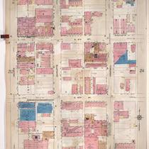
Title
-
Sanborn Map, Kansas City, Vol. 2, 1909-1937, Page p218
-
Description
-
A portion of Kansas City from E. 8th Street south to E. 11th Street and from Euclid Avenue east to Park Avenue, showing buildings, streets, and additions. Large numbers at edges of page refer to page with adjoining area.
-
Date
-
1909/1937
-
Object Type
-
Map
-

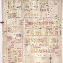
-
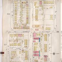
Title
-
Sanborn Map, Kansas City, Vol. 2, 1909-1937, Page p221
-
Description
-
A portion of Kansas City from E. 8th Street south to E. 11th Street and from Agnes Avenue east to Benton Boulevard, showing buildings, streets, and additions. Large numbers at edges of page refer to page with adjoining area.
-
Date
-
1909/1937
-
Object Type
-
Map
-

-
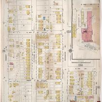
Title
-
Sanborn Map, Kansas City, Vol. 5, 1909-1938, Page p709
-
Description
-
A portion of Kansas City from E. 10th Street south to E. 12th Street and from Crystal Avenue east to Eastern Avenue, showing buildings, streets, railroads, and additions. Large numbers at edges of page refer to page with adjoining area. At the top of page, "Add'l Sheet, Aug. 1912."
-
Date
-
1909/1938
-
Object Type
-
Map
-

-
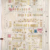
Title
-
Sanborn Map, Kansas City, Vol. 5, 1909-1938, Page p694
-
Description
-
A portion of Kansas City from E. 9th Street south to E. 11th Street and from Bennington Avenue east to Winchester Avenue, showing buildings, streets, and additions. Large numbers at edges of page refer to page with adjoining area.
-
Date
-
1909/1938
-
Object Type
-
Map
-
-
Title
-
Sanborn Map, Kansas City, Vol. 2, 1909-1937, Page p213
-
Description
-
A portion of Kansas City from E. 8th Street south to E. 11th Street and from Holmes east to Campbell, showing buildings, streets, and additions. Large numbers at edges of page refer to page with adjoining area.
-
Date
-
1909/1937
-
Object Type
-
Map
-

-
Title
-
Sanborn Map, Kansas City, Vol. 5, 1909-1938, Page p651
-
Description
-
A portion of Kansas City from E. 9th Street south to E. 12th Street and from White Avenue east to Fremont Avenue, showing buildings, streets, and additions. Large numbers at edges of page refer to page with adjoining area.
-
Date
-
1909/1938
-
Object Type
-
Map
-

-
Title
-
Sanborn Map, Kansas City, Vol. 5, 1909-1938, Page p649
-
Description
-
A portion of Kansas City from Washington Park Boulevard south to E. 12th Street and from Hardesty Avenue east to Oakley Avenue, showing buildings, streets, and additions. Large numbers at edges of page refer to page with adjoining area.
-
Date
-
1909/1938
-
Object Type
-
Map
-

-
Title
-
Sanborn Map, Kansas City, Vol. 2, 1909-1937, Page p216
-
Description
-
A portion of Kansas City from E. 8th Street south to E. 11th Street and from Lydia Avenue east to Highland Avenue, showing buildings, streets, and additions. Large numbers at edges of page refer to page with adjoining area.
-
Date
-
1909/1937
-
Object Type
-
Map
-
-
Title
-
Sanborn Map, Kansas City, Vol. 5, 1909-1938, Page p645
-
Description
-
A portion of Kansas City from E. 8th Street south to E. 10th Street and from Kensington Avenue east to Van Brunt Boulevard, showing buildings, streets, and additions. Large numbers at edges of page refer to page with adjoining area.
-
Date
-
1909/1938
-
Object Type
-
Map
-

-
Title
-
Sanborn Map, Kansas City, Vol. 5, 1909-1938, Page p648
-
Description
-
A portion of Kansas City from E. 8th Street south to E. 10th Street and from Denver Avenue east to Hardesty Avenue, showing buildings, streets, railroads, and additions. Large numbers at edges of page refer to page with adjoining area.
-
Date
-
1909/1938
-
Object Type
-
Map
-
-
Title
-
Sanborn Map, Kansas City, Vol. 5, 1909-1938, Page p652
-
Description
-
A portion of Kansas City from E. 9th Street south to E. 12th Street and from Fremont Avenue east to Newton Avenue, showing buildings, streets, and additions. Large numbers at edges of page refer to page with adjoining area.
-
Date
-
1909/1938
-
Object Type
-
Map
-
-
Title
-
Sanborn Map, Kansas City, Vol. 5, 1909-1938, Page p641
-
Description
-
A portion of Kansas City from E. 8th Street south to E. 11th Street and from Cleveland Avenue east to Norton Avenue, showing buildings, streets, and additions. Large numbers at edges of page refer to page with adjoining area.
-
Date
-
1909/1938
-
Object Type
-
Map
-

-
Title
-
Sanborn Map, Kansas City, Vol. 5, 1909-1938, Page p647
-
Description
-
A portion of Kansas City from E. 8th Street south to E. 10th Street and from Van Brunt Boulevard east to Brighton Avenue, showing buildings, streets, railroads, and additions. Large numbers at edges of page refer to page with adjoining area.
-
Date
-
1909/1938
-
Object Type
-
Map
-

-
Title
-
Sanborn Map, Kansas City, Vol. 5, 1909-1938, Page p650
-
Description
-
A portion of Kansas City from E. 9th Street south to E. 12th Street and from Topping Avenue east to White Avenue, showing buildings, streets, and additions. Large numbers at edges of page refer to page with adjoining area.
-
Date
-
1909/1938
-
Object Type
-
Map
-

-
Title
-
Sanborn Map, Kansas City, Vol. 5, 1909-1938, Page p643
-
Description
-
A portion of Kansas City from E. 8th Street south to E. 10th Street Terrace and from Norton Avenue east to Kensington Avenue, showing buildings, streets, and additions. Large numbers at edges of page refer to page with adjoining area.
-
Date
-
1909/1938
-
Object Type
-
Map
-

-
Title
-
Sanborn Map, Kansas City, Vol. 6, 1917-1957, Page p840
-
Description
-
A portion of Kansas City from Independence Avenue south to E. 11th Street and from Overton Avenue east to S. Hardy Avenue, showing buildings, streets, and additions. Large numbers at edges of page refer to page with adjoining area.
-
Date
-
1917/1957
-
Object Type
-
Map
-

-
Title
-
Sanborn Map, Kansas City, Vol. 2, 1909-1937, Page p212
-
Description
-
A portion of Kansas City from E. 8th Street south to E. 11th Street and from Oak Street east to Holmes Street, showing buildings, streets, and additions. Large numbers at edges of page refer to page with adjoining area.
-
Date
-
1909/1937
-
Object Type
-
Map
-

-
Title
-
Sanborn Map, Kansas City, Vol. 2, 1909-1937, Page p217
-
Description
-
A portion of Kansas City from E. 8th Street south to E. 11th Street and from Highland Avenue east to Euclid Avenue, showing buildings, streets, and additions. Large numbers at edges of page refer to page with adjoining area.
-
Date
-
1909/1937
-
Object Type
-
Map
-
-
Title
-
Sanborn Map, Kansas City, Vol. 2, 1909-1937, Page p215
-
Description
-
A portion of Kansas City from E. 8th Street south to E. 11th Street and from Forest Avenue east to Lydia Avenue, showing buildings, streets, and additions. Large numbers at edges of page refer to page with adjoining area.
-
Date
-
1909/1937
-
Object Type
-
Map
-
-
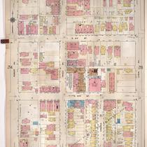
Title
-
Sanborn Map, Kansas City, Vol. 2, 1909-1937, Page p219
-
Description
-
A portion of Kansas City from E. 8th Street south to E. 11th Street and from Park Avenue east to Prospect Avenue, showing buildings, streets, and additions. Large numbers at edges of page refer to page with adjoining area.
-
Date
-
1909/1937
-
Object Type
-
Map
Pages
