Pages
-

-
Title
-
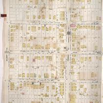
Sanborn Map, Kansas City, Vol. 5, 1909-1938, Page p659
-
Description
-
A portion of Kansas City from E. 12th Street south to E. 15th Street and from Oakley Avenue east to Bellaire Avenue, showing buildings, streets, and additions. Large numbers at edges of page refer to page with adjoining area.
-
Date
-
1909/1938
-
Object Type
-
Map
-

-
Title
-
Sanborn Map, Kansas City, Vol. 2, 1909-1937, Page p229
-
Description
-
A portion of Kansas City from E. 11th Street south to E. 13th Street and from Oak Street east to Cherry Street, showing buildings, streets, and additions. Large numbers at edges of page refer to page with adjoining area.
-
Date
-
1909/1937
-
Object Type
-
Map
-

-
Title
-
Sanborn Map, Kansas City, Vol. 5, 1909-1938, Page p642
-
Description
-
A portion of Kansas City from E. 11th Street south to E. 13th Street and from Cleveland Avenue east to Norton Avenue, showing buildings, streets, and additions. Large numbers at edges of page refer to page with adjoining area.
-
Date
-
1909/1938
-
Object Type
-
Map
-
-
Title
-
Sanborn Map, Kansas City, Vol. 5, 1909-1938, Page p709
-
Description
-
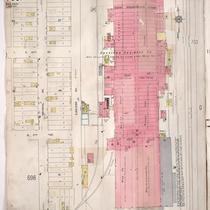
A portion of Kansas City from E. 10th Street south to E. 12th Street and from Crystal Avenue east to Eastern Avenue, showing buildings, streets, railroads, and additions. Large numbers at edges of page refer to page with adjoining area. At the top of page, "Add'l Sheet, Aug. 1912."
-
Date
-
1909/1938
-
Object Type
-
Map
-
-
Title
-
Sanborn Map, Kansas City, Vol. 2, 1909-1937, Page p237
-
Description
-
A portion of Kansas City from E. 11th Street south to E. 13th Street and from Park Avenue east to Prospect Avenue, showing buildings, streets, and additions. Large numbers at edges of page refer to page with adjoining area.
-
Date
-
1909/1937
-
Object Type
-
Map
-

-
Title
-
Sanborn Map, Kansas City, Vol. 2, 1909-1937, Page p233
-
Description
-
A portion of Kansas City from E. 11th Street south to E. 13th Street and from Forest Avenue east to Lydia Avenue, showing buildings, streets, and additions. Large numbers at edges of page refer to page with adjoining area.
-
Date
-
1909/1937
-
Object Type
-
Map
-
-
Title
-
Sanborn Map, Kansas City, Vol. 2, 1909-1937, Page p240
-
Description
-
A portion of Kansas City from E. 11th Street south to E. 13th Street and from Benton Boulevard east to Bales Avenue, showing buildings, streets, and additions. Large numbers at edges of page refer to page with adjoining area.
-
Date
-
1909/1937
-
Object Type
-
Map
-

-
Title
-
Sanborn Map, Kansas City, Vol. 2, 1909-1937, Page p231
-
Description
-
A portion of Kansas City from E. 11th Street south to E. 13th Street and from Charlotte Street east to Harrison Street, showing buildings, streets, and additions. Large numbers at edges of page refer to page with adjoining area.
-
Date
-
1909/1937
-
Object Type
-
Map
-

-
Title
-
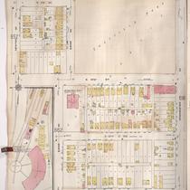
Sanborn Map, Kansas City, Vol. 5, 1909-1938, Page p657
-
Description
-
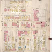
A portion of Kansas City from E. 12th Street south to E. 15th Street and from Van Brunt Boulevard east to Colorado Avenue, showing buildings, streets, and additions. Large numbers at edges of page refer to page with adjoining area.
-
Date
-
1909/1938
-
Object Type
-
Map
-

-
Title
-
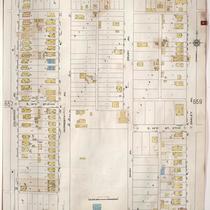
Sanborn Map, Kansas City, Vol. 5, 1909-1938, Page p655
-
Description
-
A portion of Kansas City from E. 12th Street south to E. 14th Street and from Norton Avenue east to Kensington Avenue, showing buildings, streets, and additions. Large numbers at edges of page refer to page with adjoining area.
-
Date
-
1909/1938
-
Object Type
-
Map
-

-
Title
-
Sanborn Map, Kansas City, Vol. 5, 1909-1938, Page p660
-
Description
-
A portion of Kansas City from E. 12th Street south to E. 15th Street and from Bellaire Avenue east to Belmont Avenue, showing buildings, streets, and additions. Large numbers at edges of page refer to page with adjoining area.
-
Date
-
1909/1938
-
Object Type
-
Map
-

-
Title
-
Sanborn Map, Kansas City, Vol. 5, 1909-1938, Page p651
-
Description
-
A portion of Kansas City from E. 9th Street south to E. 12th Street and from White Avenue east to Fremont Avenue, showing buildings, streets, and additions. Large numbers at edges of page refer to page with adjoining area.
-
Date
-
1909/1938
-
Object Type
-
Map
-
-
Title
-
Sanborn Map, Kansas City, Vol. 5, 1909-1938, Page p649
-
Description
-
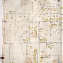
A portion of Kansas City from Washington Park Boulevard south to E. 12th Street and from Hardesty Avenue east to Oakley Avenue, showing buildings, streets, and additions. Large numbers at edges of page refer to page with adjoining area.
-
Date
-
1909/1938
-
Object Type
-
Map
-

-
Title
-
Sanborn Map, Kansas City, Vol. 2, 1909-1937, Page p232
-
Description
-
A portion of Kansas City from E. 11th Street south to E. 13th Street and from Harrison Street east to Forest Avenue, showing buildings, streets, and additions. Large numbers at edges of page refer to page with adjoining area.
-
Date
-
1909/1937
-
Object Type
-
Map
-

-
Title
-
Sanborn Map, Kansas City, Vol. 2, 1909-1937, Page p226
-
Description
-
A portion of Kansas City from E. 11th Street south to E. 13th Street and from Walnut Street east to Grand Avenue, showing buildings, streets, and additions. Large numbers at edges of page refer to page with adjoining area.
-
Date
-
1909/1937
-
Object Type
-
Map
-
-
Title
-
Sanborn Map, Kansas City, Vol. 5, 1909-1938, Page p661
-
Description
-
A portion of Kansas City from E. 12th Street south to E. 15th Street and from Belmont Avenue east to Fremont Avenue, showing buildings, streets, and additions. Large numbers at edges of page refer to page with adjoining area.
-
Date
-
1909/1938
-
Object Type
-
Map
-

-
Title
-
Sanborn Map, Kansas City, Vol. 5, 1909-1938, Page p652
-
Description
-
A portion of Kansas City from E. 9th Street south to E. 12th Street and from Fremont Avenue east to Newton Avenue, showing buildings, streets, and additions. Large numbers at edges of page refer to page with adjoining area.
-
Date
-
1909/1938
-
Object Type
-
Map
-
-
Title
-
Sanborn Map, Kansas City, Vol. 5, 1909-1938, Page p695
-
Description
-
A portion of Kansas City from E. 11th Street south to E. 13th Street and from Newton Avenue east to Winchester Avenue, showing buildings, streets, and additions. Large numbers at edges of page refer to page with adjoining area.
-
Date
-
1909/1938
-
Object Type
-
Map
-
-
Title
-
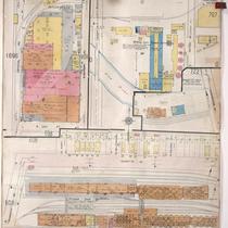
Sanborn Map, Kansas City, Vol. 5, 1909-1938, Page p710
-
Description
-
A portion of Kansas City in the Blue Valley Industrial District, showing buildings, streets, railroads, and additions. Large numbers at edges of page refer to page with adjoining area. At the top of page, "Add'l Sheet, Aug. 1912."
-
Date
-
1909/1938
-
Object Type
-
Map
-
-
Title
-
Sanborn Map, Kansas City, Vol. 5, 1909-1938, Page p658
-
Description
-
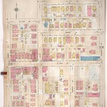
A portion of Kansas City from E. 12th Street south to E. 15th Street and from Colorado Avenue east to Oakley Avenue, showing buildings, streets, and additions. Large numbers at edges of page refer to page with adjoining area.
-
Date
-
1909/1938
-
Object Type
-
Map
Pages
