Pages
-
-
Title
-
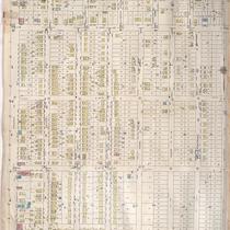
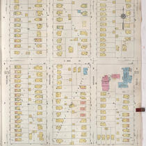
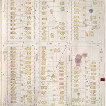
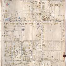
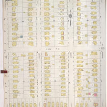
Sanborn Map, Kansas City, Vol. 6, 1917-1957, Page p853
-
Description
-
A portion of Kansas City, Missouri, from E. 55th Street south to E. 58th Street and from Prospect Avenue east to Walrond Avenue, showing buildings, streets, and additions. Large numbers at edges of page refer to page with adjoining area. Noted at top of map, "(786) Add'l Sheet, Nov. 1935."
-
Date
-
1917/1957
-
Object Type
-
Map
-
-
Title
-
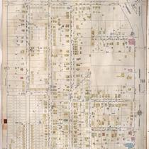
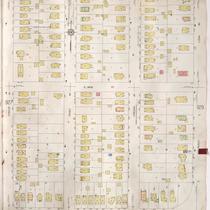
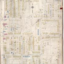
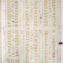
Sanborn Map, Kansas City, Vol. 6, 1917-1957, Page p787
-
Description
-
A portion of eastern Kansas City from E. 55th Street south to E. 58th Street Terrace and from Walrond Avenue east to Swope Parkway, showing buildings, streets, and additions. Large numbers at edges of page refer to page with adjoining area.
-
Date
-
1917/1957
-
Object Type
-
Map
-
-
Title
-
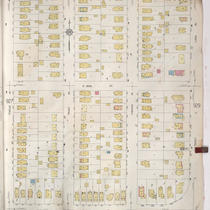
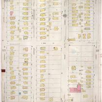
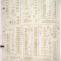
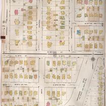
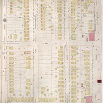
Sanborn Map, Kansas City, Vol. 9, 1930-1957, Page p0928
-
Description
-
A portion of Kansas City from E. 58th Street south to E. 59th Street and from Forest Avenue east to Paseo Boulevard, showing buildings, streets, and additions. Large numbers at edges of page refer to page with adjoining area.
-
Date
-
1930/1957
-
Object Type
-
Map
-
-
Title
-
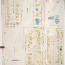
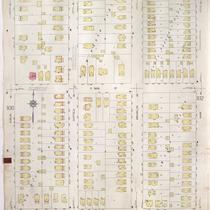
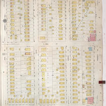
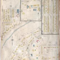
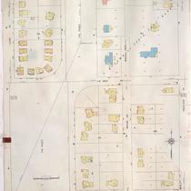
Sanborn Map, Kansas City, Vol. 9, 1930-1957, Page p0929
-
Description
-
A portion of Kansas City from E. 58th Street south to E. 59th Street and from Lydia Avenue east to Highland Avenue, showing buildings, streets, and additions. Large numbers at edges of page refer to page with adjoining area.
-
Date
-
1930/1957
-
Object Type
-
Map
-
-
Title
-
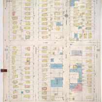
Sanborn Map, Kansas City, Vol. 9, 1930-1957, Page p0930
-
Description
-
A portion of Kansas City from E. 58th Street south to E. 59th Street and from Highland Avenue east to Euclid Avenue, showing buildings, streets, and additions. Large numbers at edges of page refer to page with adjoining area.
-
Date
-
1930/1957
-
Object Type
-
Map
-
-
Title
-
Sanborn Map, Kansas City, Vol. 9, 1930-1941, Page p0928
-
Description
-
A portion of Kansas City from E. 58th Street south to E. 59th Street and from Forest Avenue east to Paseo Boulevard, showing buildings, streets, and additions. Large numbers at edges of page refer to page with adjoining area.
-
Date
-
1930/1941
-
Object Type
-
Map
-
-
Title
-
Sanborn Map, Kansas City, Vol. 9, 1930-1941, Page p0927
-
Description
-
A portion of Kansas City from E. 58th Street south to E, 59th Street and from Rockhill Road east to Forest Avenue, showing buildings, streets, and additions. Large numbers at edges of page refer to page with adjoining area.
-
Date
-
1930/1941
-
Object Type
-
Map
-
-
Title
-
Sanborn Map, Kansas City, Vol. 9, 1930-1941, Page p0931
-
Description
-
A portion of Kansas City from E. 58th Street south to E. 59th Street and from Euclid Avenue east to Park Avenue, showing buildings, streets, and additions. Large numbers at edges of page refer to page with adjoining area.
-
Date
-
1930/1941
-
Object Type
-
Map
-
-
Title
-
Sanborn Map, Kansas City, Vol. 9, 1930-1941, Page p0930
-
Description
-
A portion of Kansas City from E. 58th Street south to E. 59th Street and from Highland Avenue east to Euclid Avenue, showing buildings, streets, and additions. Large numbers at edges of page refer to page with adjoining area.
-
Date
-
1930/1941
-
Object Type
-
Map
-
-
Title
-
Sanborn Map, Kansas City, Vol. 9, 1930-1957, Page p0931
-
Description
-
A portion of Kansas City from E. 58th Street south to E. 59th Street and from Euclid Avenue east to Park Avenue, showing buildings, streets, and additions. Large numbers at edges of page refer to page with adjoining area.
-
Date
-
1930/1957
-
Object Type
-
Map
-
-
Title
-
Sanborn Map, Kansas City, Vol. 9, 1930-1957, Page p0932
-
Description
-
A portion of Kansas City from E. 58th Street south to E. 59th Street and from Park Avenue east to Prospect Avenue, showing buildings, streets, and additions. Large numbers at edges of page refer to page with adjoining area.
-
Date
-
1930/1957
-
Object Type
-
Map
-
-
Title
-
Sanborn Map, Kansas City, Vol. 9, 1930-1957, Page p0927
-
Description
-
A portion of Kansas City from E. 58th Street south to E, 59th Street and from Rockhill Road east to Forest Avenue, showing buildings, streets, and additions. Large numbers at edges of page refer to page with adjoining area.
-
Date
-
1930/1957
-
Object Type
-
Map
-
-
Title
-
Sanborn Map, Kansas City, Vol. 6, 1917-1957, Page p788
-
Description
-
A portion of eastern Kansas City from E. 55th Street south to E. 58th Street Terrace and from Swope Parkway east to Kensington Avenue, showing buildings, streets, and additions. Large numbers at edges of page refer to page with adjoining area.
-
Date
-
1917/1957
-
Object Type
-
Map
-
-
Title
-
Sanborn Map, Kansas City, Vol. 6, 1917-1957, Page p856
-
Description
-
A portion of Kansas City, Missouri, from E. 58th Street south to E. 61st Street and from Prospect Avenue east to Walrond Avenue, showing buildings, streets, and additions. Large numbers at edges of page refer to page with adjoining area. Noted at top of map, "Add'l Sheet, Nov. 1937."
-
Date
-
1917/1957
-
Object Type
-
Map
-
-
Title
-
Sanborn Map, Kansas City, Vol. 6, 1917-1957, Page p813
-
Description
-
A portion of Kansas City from 57th Street south to 58th Street and from Wornall Road east to Brookside Boulevard, showing buildings, streets, and additions. Large numbers at edges of page refer to page with adjoining area.
-
Date
-
1917/1957
-
Object Type
-
Map
-
-
Title
-
Sanborn Map, Kansas City, Vol. 6, 1917-1957, Page p827
-
Description
-
A portion of Kansas City from W. 48th Street south to W. 51st Street and from Holly Street east to Pennsylvania Avenue and a portion of Brookside, showing buildings, streets, and additions. Large numbers at edges of page refer to page with adjoining area. Noted at top of page, "New Sheet Dec. 1931."
-
Date
-
1917/1957
-
Object Type
-
Map
-
-
Title
-
Sanborn Map, Kansas City, Vol. 9, 1930-1957, Page p0925
-
Description
-
A portion of Kansas City from E. 58th Street south to E. 59th Street and from Oak Street east to Kenwood Avenue, showing buildings, streets, and additions. Large numbers at edges of page refer to page with adjoining area.
-
Date
-
1930/1957
-
Object Type
-
Map
-
-
Title
-
Sanborn Map, Kansas City, Vol. 9, 1930-1957, Page p0926
-
Description
-
A portion of Kansas City from E. 58th Street south to E. 59th Street and from Kenwood Avenue east to Rockhill Road, showing buildings, streets, and additions. Large numbers at edges of page refer to page with adjoining area.
-
Date
-
1930/1957
-
Object Type
-
Map
-
-
Title
-
Sanborn Map, Kansas City, Vol. 9, 1930-1941, Page p0932
-
Description
-
A portion of Kansas City from E. 58th Street south to E. 59th Street and from Park Avenue east to Prospect Avenue, showing buildings, streets, and additions. Large numbers at edges of page refer to page with adjoining area.
-
Date
-
1930/1941
-
Object Type
-
Map
-
-
Title
-
Sanborn Map, Kansas City, Vol. 9, 1930-1941, Page p0929
-
Description
-
A portion of Kansas City from E. 58th Street south to E. 59th Street and from Lydia Avenue east to Highland Avenue, showing buildings, streets, and additions. Large numbers at edges of page refer to page with adjoining area.
-
Date
-
1930/1941
-
Object Type
-
Map
Pages
