Pages
-
-
Title
-
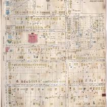
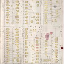
Sanborn Map, Kansas City, Vol. 6, 1917-1957, Page p790
-
Description
-
A portion of eastern Kansas City from E. 58th Street Terrace south to E. 62nd Street and from Swope Parkway east to Cypress Avenue, showing buildings, streets, and additions. Large numbers at edges of page refer to page with adjoining area.
-
Date
-
1917/1957
-
Object Type
-
Map
-
-
Title
-
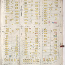
Sanborn Map, Kansas City, Vol. 9, 1930-1957, Page p0928
-
Description
-
A portion of Kansas City from E. 58th Street south to E. 59th Street and from Forest Avenue east to Paseo Boulevard, showing buildings, streets, and additions. Large numbers at edges of page refer to page with adjoining area.
-
Date
-
1930/1957
-
Object Type
-
Map
-

-
Title
-
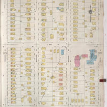
Sanborn Map, Kansas City, Vol. 9, 1930-1957, Page p0935
-
Description
-
A portion of Kansas City from E. 59th Street south to E. 61st Street and from Rockhill Road east to Forest Avenue, showing buildings, streets, and additions. Large numbers at edges of page refer to page with adjoining area.
-
Date
-
1930/1957
-
Object Type
-
Map
-

-
Title
-
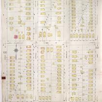
Sanborn Map, Kansas City, Vol. 9, 1930-1957, Page p0936
-
Description
-
A portion of Kansas City from E. 59th Street south to E. 61st Street and from Forest Avenue east to Paseo Boulevard, showing buildings, streets, and additions. Large numbers at edges of page refer to page with adjoining area.
-
Date
-
1930/1957
-
Object Type
-
Map
-

-
Title
-
Sanborn Map, Kansas City, Vol. 9, 1930-1957, Page p0929
-
Description
-
A portion of Kansas City from E. 58th Street south to E. 59th Street and from Lydia Avenue east to Highland Avenue, showing buildings, streets, and additions. Large numbers at edges of page refer to page with adjoining area.
-
Date
-
1930/1957
-
Object Type
-
Map
-
-
Title
-
Sanborn Map, Kansas City, Vol. 9, 1930-1957, Page p0930
-
Description
-
A portion of Kansas City from E. 58th Street south to E. 59th Street and from Highland Avenue east to Euclid Avenue, showing buildings, streets, and additions. Large numbers at edges of page refer to page with adjoining area.
-
Date
-
1930/1957
-
Object Type
-
Map
-

-
Title
-
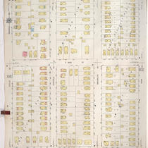
Sanborn Map, Kansas City, Vol. 9, 1930-1941, Page p0928
-
Description
-
A portion of Kansas City from E. 58th Street south to E. 59th Street and from Forest Avenue east to Paseo Boulevard, showing buildings, streets, and additions. Large numbers at edges of page refer to page with adjoining area.
-
Date
-
1930/1941
-
Object Type
-
Map
-

-
Title
-
Sanborn Map, Kansas City, Vol. 9, 1930-1941, Page p0942
-
Description
-
A portion of Kansas City from E. 59th Street south to E. 63rd Street and from Brooklyn Avenue east to Prospect Avenue, showing buildings, streets, and additions. Large numbers at edges of page refer to page with adjoining area.
-
Date
-
1930/1941
-
Object Type
-
Map
-

-
Title
-
Sanborn Map, Kansas City, Vol. 9, 1930-1941, Page p0927
-
Description
-
A portion of Kansas City from E. 58th Street south to E, 59th Street and from Rockhill Road east to Forest Avenue, showing buildings, streets, and additions. Large numbers at edges of page refer to page with adjoining area.
-
Date
-
1930/1941
-
Object Type
-
Map
-
-
Title
-
Sanborn Map, Kansas City, Vol. 9, 1930-1941, Page p0931
-
Description
-
A portion of Kansas City from E. 58th Street south to E. 59th Street and from Euclid Avenue east to Park Avenue, showing buildings, streets, and additions. Large numbers at edges of page refer to page with adjoining area.
-
Date
-
1930/1941
-
Object Type
-
Map
-
-
Title
-
Sanborn Map, Kansas City, Vol. 9, 1930-1941, Page p0930
-
Description
-
A portion of Kansas City from E. 58th Street south to E. 59th Street and from Highland Avenue east to Euclid Avenue, showing buildings, streets, and additions. Large numbers at edges of page refer to page with adjoining area.
-
Date
-
1930/1941
-
Object Type
-
Map
-
-
Title
-
Sanborn Map, Kansas City, Vol. 9, 1930-1957, Page p0931
-
Description
-
A portion of Kansas City from E. 58th Street south to E. 59th Street and from Euclid Avenue east to Park Avenue, showing buildings, streets, and additions. Large numbers at edges of page refer to page with adjoining area.
-
Date
-
1930/1957
-
Object Type
-
Map
-

-
Title
-
Sanborn Map, Kansas City, Vol. 9, 1930-1957, Page p0932
-
Description
-
A portion of Kansas City from E. 58th Street south to E. 59th Street and from Park Avenue east to Prospect Avenue, showing buildings, streets, and additions. Large numbers at edges of page refer to page with adjoining area.
-
Date
-
1930/1957
-
Object Type
-
Map
-

-
Title
-
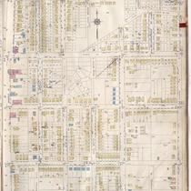
Sanborn Map, Kansas City, Vol. 9, 1930-1957, Page p0934
-
Description
-
A portion of Kansas City from E. 59th Street south to E. 61st Street and from Kenwood Avenue east to Rockhill Road, showing buildings, streets, and additions. Large numbers at edges of page refer to page with adjoining area.
-
Date
-
1930/1957
-
Object Type
-
Map
-

-
Title
-
Sanborn Map, Kansas City, Vol. 9, 1930-1957, Page p0927
-
Description
-
A portion of Kansas City from E. 58th Street south to E, 59th Street and from Rockhill Road east to Forest Avenue, showing buildings, streets, and additions. Large numbers at edges of page refer to page with adjoining area.
-
Date
-
1930/1957
-
Object Type
-
Map
-

-
Title
-
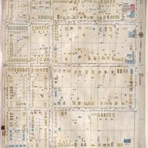
Sanborn Map, Kansas City, Vol. 9, 1930-1957, Page p0942
-
Description
-
A portion of Kansas City from E. 59th Street south to E. 63rd Street and from Brooklyn Avenue east to Prospect Avenue, showing buildings, streets, and additions. Large numbers at edges of page refer to page with adjoining area.
-
Date
-
1930/1957
-
Object Type
-
Map
-

-
Title
-
Sanborn Map, Kansas City, Vol. 9, 1930-1957, Page p0941
-
Description
-
A portion of Kansas City from E. 59th Street south to E. 63rd Street and from Paseo Boulevard east to just about Brooklyn Avenue, showing buildings, streets, and additions. Large numbers at edges of page refer to page with adjoining area.
-
Date
-
1930/1957
-
Object Type
-
Map
-
-
Title
-
Sanborn Map, Kansas City, Vol. 6, 1917-1957, Page p856
-
Description
-
A portion of Kansas City, Missouri, from E. 58th Street south to E. 61st Street and from Prospect Avenue east to Walrond Avenue, showing buildings, streets, and additions. Large numbers at edges of page refer to page with adjoining area. Noted at top of map, "Add'l Sheet, Nov. 1937."
-
Date
-
1917/1957
-
Object Type
-
Map
-
-
Title
-
Sanborn Map, Kansas City, Vol. 6, 1917-1957, Page p789
-
Description
-
A portion of eastern Kansas City from E. 58th Street Terrace south to E. 62nd Street and from Walrond Avenue east to Swope Parkway, showing buildings, streets, and additions. Large numbers at edges of page refer to page with adjoining area.
-
Date
-
1917/1957
-
Object Type
-
Map
-

-
Title
-
Sanborn Map, Kansas City, Vol. 6, 1917-1957, Page p827
-
Description
-
A portion of Kansas City from W. 48th Street south to W. 51st Street and from Holly Street east to Pennsylvania Avenue and a portion of Brookside, showing buildings, streets, and additions. Large numbers at edges of page refer to page with adjoining area. Noted at top of page, "New Sheet Dec. 1931."
-
Date
-
1917/1957
-
Object Type
-
Map
Pages
