Pages
-
-
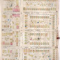
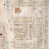
Title
-
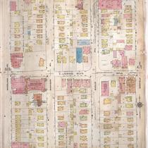
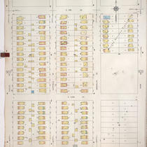
Sanborn Map, Kansas City, Vol. 4, 1909-1957, Page p486
-
Description
-
A portion of Kansas City from E. 35th Street south to E. 36th Street and from Michigan Avenue east to Park Avenue, showing buildings, streets, and additions. Large numbers at edges of page refer to page with adjoining area.
-
Date
-
1909/1957
-
Object Type
-
Map
-
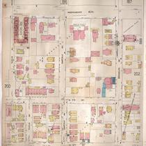
-
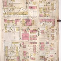
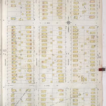
Title
-
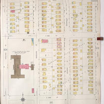
Sanborn Map, Kansas City, Vol. 2, 1909-1937, Page p218
-
Description
-
A portion of Kansas City from E. 8th Street south to E. 11th Street and from Euclid Avenue east to Park Avenue, showing buildings, streets, and additions. Large numbers at edges of page refer to page with adjoining area.
-
Date
-
1909/1937
-
Object Type
-
Map
-
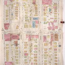
-
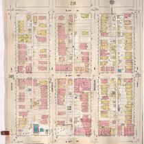
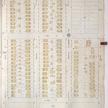
Title
-
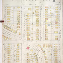
Sanborn Map, Kansas City, Vol. 2, 1909-1937, Page p249
-
Description
-
A portion of Kansas City from E. 13th Street south to E. 15th Street and from Euclid Avenue east to Park Avenue, showing buildings, streets, and additions. Large numbers at edges of page refer to page with adjoining area.
-
Date
-
1909/1937
-
Object Type
-
Map
-
-
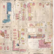
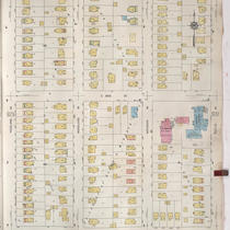
Title
-
Sanborn Map, Kansas City, Vol. 2, 1909-1937, Page p200
-
Description
-
A portion of Kansas City from Independence Boulevard south to E. 8th Street and from Highland Avenue east to Euclid Avenue, showing buildings, streets and additions. Large numbers at edges of page refer to page with adjoining area.
-
Date
-
1909/1937
-
Object Type
-
Map
-
-
Title
-
Sanborn Map, Kansas City, Vol. 2, 1909-1937, Page p201
-
Description
-
A portion of Kansas City from Independence Boulevard south to E. 8th Street and from Euclid Avenue east to Brooklyn Avenue, showing buildings, streets, and additions. Large numbers at edges of page refer to page with adjoining area.
-
Date
-
1909/1937
-
Object Type
-
Map
-
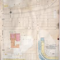
-
Title
-
Sanborn Map, Kansas City, Vol. 3, 1909-1957, Page p334
-
Description
-
A portion of Kansas City from E. 19th Street Terrace south to E. 22nd Street and from Woodland Avenue east to Euclid Avenue, showing buildings, streets, and additions. Large numbers at edges of page refer to page with adjoining area.
-
Date
-
1909/1957
-
Object Type
-
Map
-
-
Title
-
Sanborn Map, Kansas City, Vol. 4, 1909-1957, Page p470
-
Description
-
A portion of Kansas City from E. 31st Street south to E. 33rd Street and from Woodland Avenue east to Garfield Avenue, showing buildings, streets, and additions. Large numbers at edges of page refer to page with adjoining area.
-
Date
-
1909/1957
-
Object Type
-
Map
-
-
Title
-
Sanborn Map, Kansas City, Vol. 3, 1909-1957, Page p355
-
Description
-
A portion of Kansas City from E. 22nd Street south to E. 24th Street and from Euclid Avenue east to Park Avenue, showing buildings, streets, and additions. Large numbers at edges of page refer to page with adjoining area.
-
Date
-
1909/1957
-
Object Type
-
Map
-
-
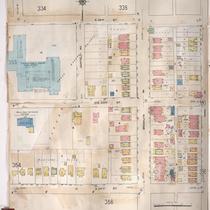
Title
-
Sanborn Map, Kansas City, Vol. 4, 1909-1950, Page p470
-
Description
-
A portion of Kansas City from E. 31st Street south to E. 33rd Street and from Woodland Avenue east to Garfield Avenue, showing buildings, streets, and additions. Large numbers at edges of page refer to page with adjoining area.
-
Date
-
1909/1950
-
Object Type
-
Map
-
-
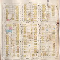
Title
-
Sanborn Map, Kansas City, Vol. 6, 1917-1957, Page p763
-
Description
-
A portion of northeastern Kansas City from E. 39th Street south to about E. 41st Street and from Michigan Avenue east to Brooklyn Avenue, showing buildings, streets, and additions. Large numbers at edges of page refer to page with adjoining area.
-
Date
-
1917/1957
-
Object Type
-
Map
-
-
Title
-
Sanborn Map, Kansas City, Vol. 6, 1917-1957, Page p772
-
Description
-
A portion of northeastern Kansas City from E. 44th Street south to about E. 46th Street and from Michigan Avenue east to Brooklyn Avenue, showing buildings, streets, and additions. Large numbers at edges of page refer to page with adjoining area.
-
Date
-
1917/1957
-
Object Type
-
Map
-
-
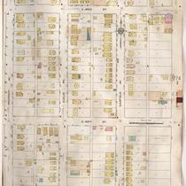
Title
-
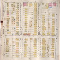
Sanborn Map, Kansas City, Vol. 6, 1917-1957, Page p764
-
Description
-
A portion of northeastern Kansas City from about E. 40th Street south to E. 42nd Street and from Michigan Avenue east to Brooklyn Avenue, showing buildings, streets, and additions. Large numbers at edges of page refer to page with adjoining area.
-
Date
-
1917/1957
-
Object Type
-
Map
-

-
Title
-
Sanborn Map, Kansas City, Vol. 6, 1917-1957, Page p771
-
Description
-
A portion of northeastern Kansas City from E. 42nd Street south to about E. 44th Street and from Michigan Avenue east to Brooklyn Avenue, showing buildings, streets, and additions. Large numbers at edges of page refer to page with adjoining area.
-
Date
-
1917/1957
-
Object Type
-
Map
-
-
Title
-
Sanborn Map, Kansas City, Vol. 6, 1917-1957, Page p781
-
Description
-
A portion of northeastern Kansas City from Swope Parkway south to E. 51st Street and from The Paseo east to Euclid Avenue, showing buildings, streets, and additions. Large numbers at edges of page refer to page with adjoining area.
-
Date
-
1917/1957
-
Object Type
-
Map
-
-
Title
-
Sanborn Map, Kansas City, Vol. 9, 1930-1957, Page p0924
-
Description
-
A portion of Kansas City from E. 56th Street south to E. 57th Street and from Highland Avenue east to Euclid Avenue, showing buildings, streets, and additions. Large numbers at edges of page refer to page with adjoining area.
-
Date
-
1930/1957
-
Object Type
-
Map
-
-
Title
-
Sanborn Map, Kansas City, Vol. 9, 1930-1957, Page p0908
-
Description
-
A portion of Kansas City from E. 53rd Street south to E. 54th Street and from Euclid Avenue east to Park Avenue, showing buildings, streets, and additions. Large numbers at edges of page refer to page with adjoining area.
-
Date
-
1930/1957
-
Object Type
-
Map
-
-
Title
-
Sanborn Map, Kansas City, Vol. 9, 1930-1957, Page p0930
-
Description
-
A portion of Kansas City from E. 58th Street south to E. 59th Street and from Highland Avenue east to Euclid Avenue, showing buildings, streets, and additions. Large numbers at edges of page refer to page with adjoining area.
-
Date
-
1930/1957
-
Object Type
-
Map
-
-
Title
-
Sanborn Map, Kansas City, Vol. 9, 1930-1957, Page p0907
-
Description
-
A portion of Kansas City from E. 51st Street south to E. 52nd Street and from Euclid Avenue east to Park Avenue, showing buildings, streets, and additions. Large numbers at edges of page refer to page with adjoining area.
-
Date
-
1930/1957
-
Object Type
-
Map
-
-
Title
-
Sanborn Map, Kansas City, Vol. 9, 1930-1957, Page p0906
-
Description
-
A portion of Kansas City from E.53rd Street south to E. 54th Street and from Highland Avenue east to Euclid Avenue, showing buildings, streets, and additions. Large numbers at edges of page refer to page with adjoining area.
-
Date
-
1930/1957
-
Object Type
-
Map
-
-
Title
-
Sanborn Map, Kansas City, Vol. 9, 1930-1957, Page p0905
-
Description
-
A portion of Kansas City from E. 51st Street south to E. 52nd Street and from Highland Avenue east to Euclid Avenue, showing buildings, streets, and additions. Large numbers at edges of page refer to page with adjoining area.
-
Date
-
1930/1957
-
Object Type
-
Map
Pages
