-

-
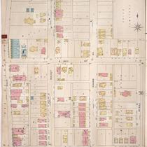
Title
-
Sanborn Map, Kansas City, Vol. 3, 1909-1957, Page p368
-
Description
-
A portion of Kansas City from E. 26th Street south to E. 28th Street and from Main Street east to McGee Street, showing buildings, streets, and additions. Large numbers at edges of page refer to page with adjoining area.
-
Date
-
1909/1957
-
Object Type
-
Map
-

-
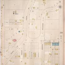
Title
-
Sanborn Map, Kansas City, Vol. 3, 1909-1957, Page p391
-
Description
-
A portion of Kansas City from E. 29th Street south to E. 30th Street and from Main Street east to McGee Street, showing buildings, streets, and additions. Large numbers at edges of page refer to page with adjoining area.
-
Date
-
1909/1957
-
Object Type
-
Map
-

-
Title
-
Sanborn Map, Kansas City, Vol. 3, 1909-1950, Page p391
-
Description
-
A portion of Kansas City from E. 29th Street south to E. 30th Street and from Main Street east to McGee Street, showing buildings, streets, and additions. Large numbers at edges of page refer to page with adjoining area.
-
Date
-
1909/1950
-
Object Type
-
Map
-

-
Title
-
Sanborn Map, Kansas City, Vol. 3, 1909-1950, Page p368
-
Description
-
A portion of Kansas City from E. 26th Street south to E. 28th Street and from Main Street east to McGee Street, showing buildings, streets, and additions. Large numbers at edges of page refer to page with adjoining area.
-
Date
-
1909/1950
-
Object Type
-
Map
-
-
Title
-
Sanborn Map, Kansas City, Vol. 3, 1896-1907, Page p315
-
Description
-
Southeastern part of early Kansas City from E. 30th Street south to E. 31st Street and from Main Street east to McGee Street, showing buildings, streets, and additions. Large numbers at edges of page refer to page with the adjoining area.
-
Date
-
1896/1907
-
Object Type
-
Map
-
-
Title
-
Sanborn Map, Kansas City, Vol. 3, 1896-1907, Page p293
-
Description
-
Southeastern part of early Kansas City from E. 25th Street south to E. 27th Street and from Main Street east to McGee Street, showing buildings, streets, and additions. Large numbers at edges of page refer to page with adjoining area.
-
Date
-
1896/1907
-
Object Type
-
Map
-

-
Title
-
Sanborn Map, Kansas City, Vol. 3, 1896-1907, Page p316
-
Description
-
Southeastern part of early Kansas City from E. 30th Street south to E. 31st Street and from McGee Street east to Gillham Road, as well as a portion of E. 29th Street from Main Street east to Grand Avenue, showing buildings, streets, and additions. Large numbers at edges of page refer to page with the adjoining area.
-
Date
-
1896/1907
-
Object Type
-
Map
-

-
Title
-
Sanborn Map, Kansas City, Vol. 1, 1895-1907, Page p066
-
Description
-
Central part of early Kansas City in the Union Hill area from W. 26th Street south to W. 27th Street and from Wyandotte Street east to the edge of Union Cemetery, showing buildings, streets, and additions. Large numbers at edges of page refer to page with adjoining area.
-
Date
-
1895/1907
-
Object Type
-
Map
