Pages
-

-
Title
-
Sanborn Map, Kansas City, Vol. 2, 1896-1907, Page p117s
-
Description
-
Skeleton map of northern part of early Kansas City from E. 14th Street south to E. 16th Street and from Main Street east to McGee Street, showing outlines of buildings at the time of publication. These sheets were used to record new developments.
-
Date
-
1896/1907
-
Object Type
-
Map
-

-
Title
-
Sanborn Map, Kansas City, Vol. 2, 1896-1907, Page p116s
-
Description
-
Skeleton map of northern part of early Kansas City from E. 12th Street south to E. 14th Street and from Main Street east to McGee Street, showing outlines of buildings at the time of publication. These sheets were used to record new developments.
-
Date
-
1896/1907
-
Object Type
-
Map
-
-
Title
-
Sanborn Map, Kansas City, Vol. 2, 1896-1907, Page p114
-
Description
-
Northern part of early Kansas City from Main Street east to McGee Street and from E. 8th Street south to E. 10th Street, showing buildings, streets, and additions. Large numbers at edges of page refer to page with adjoining area.
-
Date
-
1896/1907
-
Object Type
-
Map
-

-
Title
-
Sanborn Map, Kansas City, Vol. 2, 1896-1907, Page p113s
-
Description
-
Skeleton map of northern part of early Kansas City from Main Street east to Oak Street and from Independence Avenue south to E. 8th Street, showing outlines of buildings at the date of publication. These sheets were used to record new developments.
-
Date
-
1896/1907
-
Object Type
-
Map
-

-
Title
-
Sanborn Map, Kansas City, Vol. 3, 1896-1907, Page p354
-
Description
-
Northern part of early Kansas City in Harlem, Missouri (Clay County), from Second Street south to First Street and from Bridge Street east to Oak Street, showing buildings and streets. Large numbers at edges of page refer to page with adjoining area.
-
Date
-
1896/1907
-
Object Type
-
Map
-
-
Title
-
Sanborn Map, Kansas City, Vol. 2, 1896-1907, Page p111s
-
Description
-
Skeleton map of the northern part of early Kansas City from Main Street east to Oak Street and from E. Front Street south to E. 3rd Street, showing outlines of buildings at the date of publication. These sheets were used to record new developments in the area for supplemental sheets in the future.
-
Date
-
1896/1907
-
Object Type
-
Map
-

-
Title
-
Sanborn Map, Kansas City, Vol. 3, 1896-1907, Page p251
-
Description
-
Southeastern part of early Kansas City from E. 18th Street south to E. 20th Street and from Main Street east to McGee Street, showing buildings, streets, and additions. Large numbers at edges of page refer to page with adjoining area.
-
Date
-
1896/1907
-
Object Type
-
Map
-

-
Title
-
Sanborn Map, Kansas City, Vol. 2, 1896-1907, Page p112s
-
Description
-
Skeleton map of north part of early Kansas City in the River Market district from Main Street east to Oak Street and from E. 3rd Street south to Independence Avenue, showing outlines of buildings at the date of publication. These sheets were used to record new developments.
-
Date
-
1896/1907
-
Object Type
-
Map
-

-
Title
-
Sanborn Map, Kansas City, Vol. 2, 1896-1907, Page p118
-
Description
-
Northern part of early Kansas City from E. 16th Street south to E. 18th Street and from Main Street east to McGee Street, showing buildings, streets, and additions. Large numbers at edges of page refer to page with adjoining area.
-
Date
-
1896/1907
-
Object Type
-
Map
-

-
Title
-
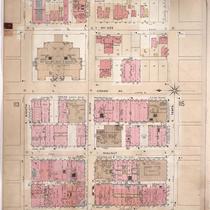
Sanborn Map, Kansas City, Vol. 2, 1896-1907, Page p116
-
Description
-
Northern part of early Kansas City from E. 12th Street south to E. 14th Street and from Main Street east to McGee Street, showing buildings, streets, and additions. Large numbers at edges of page refer to page with adjoining area.
-
Date
-
1896/1907
-
Object Type
-
Map
-

-
Title
-
Sanborn Map, Kansas City, Vol. 2, 1896-1907, Page p112
-
Description
-
Northern part of early Kansas City in the River Market district from Main Street east to Oak Street and from E. 3rd Street south to Independence Avenue, showing buildings, streets, and City Hall. Large numbers at edges of page refer to page with adjoining area.
-
Date
-
1896/1907
-
Object Type
-
Map
-

-
Title
-
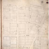
Sanborn Map, Kansas City, Vol. 2, 1896-1907, Page p115s
-
Description
-
Skeleton map of northern part of early Kansas City in the Financial District from E. 10th Street south to E. 12th Street and from Main Street east to McGee Street, showing outlines of buildings at the time of publication. These sheets were used to record new developments.
-
Date
-
1896/1907
-
Object Type
-
Map
-
-
Title
-
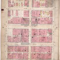
Sanborn Map, Kansas City, Vol. 2, 1896-1907, Page p115
-
Description
-
Northern part of early Kansas City in the Financial District from E. 10th Street south to E. 12th Street and from Main Street east to McGee Street, showing buildings, streets, and additions. Large numbers at edges of page refer to page with adjoining area.
-
Date
-
1896/1907
-
Object Type
-
Map
-

-
Title
-
Sanborn Map, Kansas City, Vol. 3, 1896-1907, Page p315
-
Description
-
Southeastern part of early Kansas City from E. 30th Street south to E. 31st Street and from Main Street east to McGee Street, showing buildings, streets, and additions. Large numbers at edges of page refer to page with the adjoining area.
-
Date
-
1896/1907
-
Object Type
-
Map
-

-
Title
-
Sanborn Map, Kansas City, Vol. 3, 1896-1907, Page p293
-
Description
-
Southeastern part of early Kansas City from E. 25th Street south to E. 27th Street and from Main Street east to McGee Street, showing buildings, streets, and additions. Large numbers at edges of page refer to page with adjoining area.
-
Date
-
1896/1907
-
Object Type
-
Map
-

-
Title
-
Sanborn Map, Kansas City, Vol. 3, 1896-1907, Page p292
-
Description
-
Southeastern part of early Kansas City from E. 24th Street south to E. 25th Street and from Main Street east to McGee Street, showing buildings, streets, and additions. Large numbers at edges of page refer to page with adjoining area.
-
Date
-
1896/1907
-
Object Type
-
Map
-

-
Title
-
Sanborn Map, Kansas City, Vol. 3, 1896-1907, Page p291
-
Description
-
Southeastern part of early Kansas City from E. 22nd Street south to E. 24th Street and from Main Street east to McGee Street, showing buildings, streets, and railroad lines. Large numbers at edges of page refer to page with adjoining area.
-
Date
-
1896/1907
-
Object Type
-
Map
-

-
Title
-
Sanborn Map, Kansas City, Vol. 3, 1896-1907, Page p316
-
Description
-
Southeastern part of early Kansas City from E. 30th Street south to E. 31st Street and from McGee Street east to Gillham Road, as well as a portion of E. 29th Street from Main Street east to Grand Avenue, showing buildings, streets, and additions. Large numbers at edges of page refer to page with the adjoining area.
-
Date
-
1896/1907
-
Object Type
-
Map
-

-
Title
-
Sanborn Map, Kansas City, Vol. 3, 1896-1907, Page p252
-
Description
-
Southeastern part of early Kansas City from E. 20th Street south to about E. 22nd Street and from Main Street east to McGee Street, showing buildings, streets, and railroad lines. Large numbers at edges of page refer to page with adjoining area.
-
Date
-
1896/1907
-
Object Type
-
Map
-

-
Title
-
Sanborn Map, Kansas City, Vol. 2, 1896-1907, Page p118s
-
Description
-
Skeleton map of Northern part of early Kansas City from E. 16th Street south to E. 18th Street and from Main Street east to McGee Street, showing outlines of buildings at the time of publication. These sheets were used to record new developments.
-
Date
-
1896/1907
-
Object Type
-
Map
Pages
