-

-
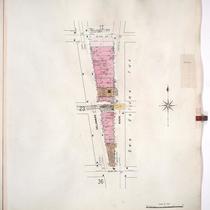
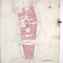
Title
-
Sanborn Map, Kansas City, Vol. 1, 1909-1938, Page p062
-
Description
-
A portion of Kansas City from W. 16th Street south to W. 18th Street and from Wyandotte east to Main Street, showing buildings, streets, and additions. Large numbers at edges of page refer to page with adjoining area.
-
Date
-
1909/1938
-
Object Type
-
Map
-

-
Title
-
Sanborn Map, Kansas City, Vol. 1, 1909-1938, Page p088
-
Description
-
A portion of Kansas City from W. 30th Street south to W. 31st Street and from Wyandotte east to Main, showing buildings, streets, and additions. Large numbers at edges of page refer to page with adjoining area.
-
Date
-
1909/1938
-
Object Type
-
Map
-
-
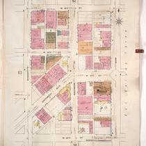
Title
-
Sanborn Map, Kansas City, Vol. 1, 1909-1938, Page p024
-
Description
-
A portion of Kansas City from W. 7th Street south to W. 9th Street and from Delaware east to Main, showing buildings, streets, and additions. Large numbers at edges of page refer to page with adjoining area.
-
Date
-
1909/1938
-
Object Type
-
Map
-

-
Title
-
Sanborn Map, Kansas City, Vol. 1, 1909-1938, Page p087
-
Description
-
A portion of Kansas City from W. 28th Street south to W. 29th Street and from Wyandotte east to Main Street, showing buildings, streets, and additions. Large numbers at edges of page refer to page with adjoining area.
-
Date
-
1909/1938
-
Object Type
-
Map
-
-
Title
-
Sanborn Map, Kansas City, Vol. 1, 1909-1938, Page p064
-
Description
-
A portion of Kansas City from W. 18th Street south to W. 20th Street and from Wyandotte Street east to Main Street, showing buildings, streets, and additions. Large numbers at edges of page refer to page with adjoining area.
-
Date
-
1909/1938
-
Object Type
-
Map
-
-
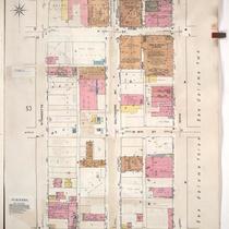
Title
-
Sanborn Map, Kansas City, Vol. 1, 1909-1938, Page p054
-
Description
-
A portion of Kansas City from W. 14th Street south to W. 16th Street and from Wyandotte east to Main, showing buildings, streets, and additions. Large numbers at edges of page refer to page with adjoining area.
-
Date
-
1909/1938
-
Object Type
-
Map
-
-
Title
-
Sanborn Map, Kansas City, Vol. 1, 1909-1938, Page p085
-
Description
-
A portion of Kansas City from Esplanade south to W. 26th Street and from Wyandotte east to Main, showing buildings, streets, and additions. Large numbers at edges of page refer to page with adjoining area.
-
Date
-
1909/1938
-
Object Type
-
Map
-

-
Title
-
Sanborn Map, Kansas City, Vol. 1, 1909-1938, Page p086
-
Description
-
A portion of Kansas City from W. 26th Street south to W. 27th Street and from Central east to Main, showing buildings, streets, and additions. Large numbers at edges of page refer to page with adjoining area.
-
Date
-
1909/1938
-
Object Type
-
Map
-

-
Title
-
Sanborn Map, Kansas City, Vol. 1, 1909-1938, Page p006
-
Description
-
A portion of Kansas City from W. Front Street south to W. 3rd Street and from Delaware east to Main Street, showing buildings, streets, and additions. Large numbers at edges of page refer to page with adjoining area.
-
Date
-
1909/1938
-
Object Type
-
Map
-

-
Title
-
Sanborn Map, Kansas City, Vol. 1, 1909-1938, Page p076
-
Description
-
A portion of Kansas City from W. 20th Street south to W. 22nd Street and from Wyandotte east to Main Street, showing buildings, streets, and additions. Large numbers at edges of page refer to page with adjoining area. Noted at top of sheet, "New Sheet April 1914 (formerly Sheet 77)."
-
Date
-
1909/1938
-
Object Type
-
Map
-

-
Title
-
Sanborn Map, Kansas City, Vol. 1, 1909-1938, Page p008
-
Description
-
A portion of Kansas City from W. 3rd Street south to W. 5th Street and from Delaware east to Main Street, showing buildings, streets, and additions. Large numbers at edges of page refer to page with adjoining area.
-
Date
-
1909/1938
-
Object Type
-
Map
-
-
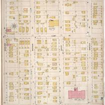
Title
-
Sanborn Map, Kansas City, Vol. 1, 1909-1938, Page p012
-
Description
-
A portion of Kansas City from W. 5th Street south to W. 7th Street and from Delaware Street east to Main Street, showing buildings, streets, and additions. Large numbers at edges of page refer to page with adjoining area.
-
Date
-
1909/1938
-
Object Type
-
Map
