Pages
-
-
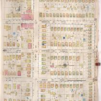
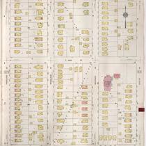
Title
-
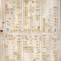
Sanborn Map, Kansas City, Vol. 4, 1909-1957, Page p486
-
Description
-
A portion of Kansas City from E. 35th Street south to E. 36th Street and from Michigan Avenue east to Park Avenue, showing buildings, streets, and additions. Large numbers at edges of page refer to page with adjoining area.
-
Date
-
1909/1957
-
Object Type
-
Map
-
-
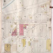
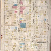
Title
-
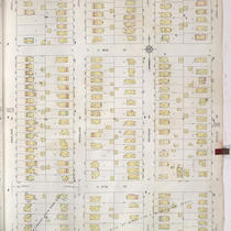
Sanborn Map, Kansas City, Vol. 5, 1909-1938, Page p604
-
Description
-
A portion of Kansas City from E. Front Street south to E. 1st Street and from N. Woodland Avenue east to Garfield Avenue, showing buildings, streets, railroads, and additions. Shows The Kansas City Star printing paper storage house. Large numbers at edges of page refer to page with adjoining area.
-
Date
-
1909/1938
-
Object Type
-
Map
-
-
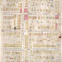
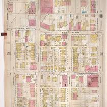
Title
-
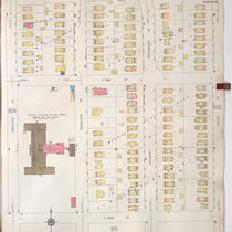
Sanborn Map, Kansas City, Vol. 4, 1909-1957, Page p484
-
Description
-
A portion of Kansas City from E. 35th Street south to E. 36th Street and from Flora Avenue east to Michigan Avenue, showing buildings, streets, and additions. Large numbers at edges of page refer to page with adjoining area.
-
Date
-
1909/1957
-
Object Type
-
Map
-

-
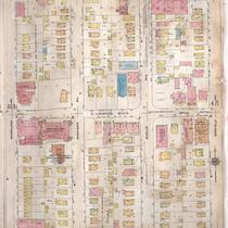
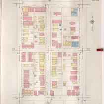
Title
-
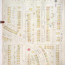
Sanborn Map, Kansas City, Vol. 4, 1909-1957, Page p470
-
Description
-
A portion of Kansas City from E. 31st Street south to E. 33rd Street and from Woodland Avenue east to Garfield Avenue, showing buildings, streets, and additions. Large numbers at edges of page refer to page with adjoining area.
-
Date
-
1909/1957
-
Object Type
-
Map
-
-
Title
-
Sanborn Map, Kansas City, Vol. 4, 1909-1950, Page p470
-
Description
-
A portion of Kansas City from E. 31st Street south to E. 33rd Street and from Woodland Avenue east to Garfield Avenue, showing buildings, streets, and additions. Large numbers at edges of page refer to page with adjoining area.
-
Date
-
1909/1950
-
Object Type
-
Map
-
-
Title
-
Sanborn Map, Kansas City, Vol. 4, 1909-1950, Page p537
-
Description
-
A portion of Kansas City from E. 39th Street south to E. 40th Street and from Flora Avenue east to Michigan Avenue, showing buildings, streets, and additions. Large numbers at edges of page refer to page with adjoining area.
-
Date
-
1909/1950
-
Object Type
-
Map
-
-
Title
-
Sanborn Map, Kansas City, Vol. 4, 1909-1950, Page p572
-
Description
-
A portion of Kansas City from E. 44th Street south to E. 45th Street and from Wayne Avenue east to Michigan Avenue, showing buildings, streets, and additions. Large numbers at edges of page refer to page with adjoining area. At top of map, "Add'l Sheet, Oct. 1916."
-
Date
-
1909/1950
-
Object Type
-
Map
-
-
Title
-
Sanborn Map, Kansas City, Vol. 6, 1917-1957, Page p763
-
Description
-
A portion of northeastern Kansas City from E. 39th Street south to about E. 41st Street and from Michigan Avenue east to Brooklyn Avenue, showing buildings, streets, and additions. Large numbers at edges of page refer to page with adjoining area.
-
Date
-
1917/1957
-
Object Type
-
Map
-

-
Title
-
Sanborn Map, Kansas City, Vol. 6, 1917-1957, Page p772
-
Description
-
A portion of northeastern Kansas City from E. 44th Street south to about E. 46th Street and from Michigan Avenue east to Brooklyn Avenue, showing buildings, streets, and additions. Large numbers at edges of page refer to page with adjoining area.
-
Date
-
1917/1957
-
Object Type
-
Map
-
-
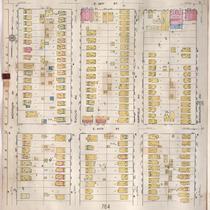
Title
-
Sanborn Map, Kansas City, Vol. 6, 1917-1957, Page p764
-
Description
-
A portion of northeastern Kansas City from about E. 40th Street south to E. 42nd Street and from Michigan Avenue east to Brooklyn Avenue, showing buildings, streets, and additions. Large numbers at edges of page refer to page with adjoining area.
-
Date
-
1917/1957
-
Object Type
-
Map
-
-
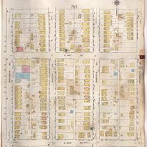
Title
-
Sanborn Map, Kansas City, Vol. 6, 1917-1957, Page p771
-
Description
-
A portion of northeastern Kansas City from E. 42nd Street south to about E. 44th Street and from Michigan Avenue east to Brooklyn Avenue, showing buildings, streets, and additions. Large numbers at edges of page refer to page with adjoining area.
-
Date
-
1917/1957
-
Object Type
-
Map
-

-
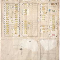
Title
-
Sanborn Map, Kansas City, Vol. 6, 1917-1957, Page p781
-
Description
-
A portion of northeastern Kansas City from Swope Parkway south to E. 51st Street and from The Paseo east to Euclid Avenue, showing buildings, streets, and additions. Large numbers at edges of page refer to page with adjoining area.
-
Date
-
1917/1957
-
Object Type
-
Map
-
-
Title
-
Sanborn Map, Kansas City, Vol. 9, 1930-1957, Page p0924
-
Description
-
A portion of Kansas City from E. 56th Street south to E. 57th Street and from Highland Avenue east to Euclid Avenue, showing buildings, streets, and additions. Large numbers at edges of page refer to page with adjoining area.
-
Date
-
1930/1957
-
Object Type
-
Map
-

-
Title
-
Sanborn Map, Kansas City, Vol. 9, 1930-1957, Page p0930
-
Description
-
A portion of Kansas City from E. 58th Street south to E. 59th Street and from Highland Avenue east to Euclid Avenue, showing buildings, streets, and additions. Large numbers at edges of page refer to page with adjoining area.
-
Date
-
1930/1957
-
Object Type
-
Map
-
-
Title
-
Sanborn Map, Kansas City, Vol. 9, 1930-1957, Page p0906
-
Description
-
A portion of Kansas City from E.53rd Street south to E. 54th Street and from Highland Avenue east to Euclid Avenue, showing buildings, streets, and additions. Large numbers at edges of page refer to page with adjoining area.
-
Date
-
1930/1957
-
Object Type
-
Map
-
-
Title
-
Sanborn Map, Kansas City, Vol. 9, 1930-1957, Page p0905
-
Description
-
A portion of Kansas City from E. 51st Street south to E. 52nd Street and from Highland Avenue east to Euclid Avenue, showing buildings, streets, and additions. Large numbers at edges of page refer to page with adjoining area.
-
Date
-
1930/1957
-
Object Type
-
Map
-
-
Title
-
Sanborn Map, Kansas City, Vol. 9, 1930-1941, Page p0930
-
Description
-
A portion of Kansas City from E. 58th Street south to E. 59th Street and from Highland Avenue east to Euclid Avenue, showing buildings, streets, and additions. Large numbers at edges of page refer to page with adjoining area.
-
Date
-
1930/1941
-
Object Type
-
Map
-
-
Title
-
Sanborn Map, Kansas City, Vol. 6, 1917-1957, Page p831
-
Description
-
A portion of Kansas City from E. 80th Street south to E. 81st Street Terrace and from Highland Avenue east to Euclid Avenue, showing buildings, streets, and additions. Large numbers at edges of page refer to page with adjoining area. Noted at top of page, "Marlborough."
-
Date
-
1917/1957
-
Object Type
-
Map
-
-
Title
-
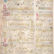
Sanborn Map, Kansas City, Vol. 2, 1909-1937, Page p217
-
Description
-
A portion of Kansas City from E. 8th Street south to E. 11th Street and from Highland Avenue east to Euclid Avenue, showing buildings, streets, and additions. Large numbers at edges of page refer to page with adjoining area.
-
Date
-
1909/1937
-
Object Type
-
Map
-
-
Title
-
Sanborn Map, Kansas City, Vol. 2, 1940-1957, Page p212
-
Description
-
A portion of northeast Kansas City from E. 12th Street south to E. 14th Street and from Woodland Avenue east to Euclid Avenue, showing buildings and streets. Large numbers at edges of page refer to page with adjoining area.
-
Date
-
1940/1957
-
Object Type
-
Map
Pages
