Pages
-

-
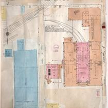
Title
-
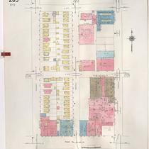
Sanborn Map, Kansas City, Vol. 3, 1909-1957, Page p306
-
Description
-
A portion of Kansas City from Truman Road south to E. 17th Street and from Tracy Avenue east to The Paseo, showing buildings, streets, and additions. Large numbers at edges of page refer to page with adjoining area.
-
Date
-
1909/1957
-
Object Type
-
Map
-

-
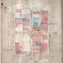
Title
-
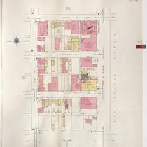
Sanborn Map, Kansas City, Vol. 3, 1909-1957, Page p302
-
Description
-
A portion of Kansas City from Truman Road south to E. 17th Street and from Grand Avenue east to Locust, showing buildings, streets, and additions. Large numbers at edges of page refer to page with adjoining area.
-
Date
-
1909/1957
-
Object Type
-
Map
-

-
Title
-
Sanborn Map, Kansas City, Vol. 3, 1909-1950, Page p305
-
Description
-
A portion of Kansas City from Truman Road south to E. 17th Street and from Troost Avenue east to Tracy Avenue, showing buildings, streets, and additions. Large numbers at edges of page refer to page with adjoining area.
-
Date
-
1909/1950
-
Object Type
-
Map
-
-
Title
-
Sanborn Map, Kansas City, Vol. 3, 1909-1950, Page p312
-
Description
-
A portion of Kansas City from Truman Road south to E. 17th Street and from Bales Avenue east to Cleveland Avenue, showing buildings, streets, and additions. Large numbers at edges of page refer to page with adjoining area.
-
Date
-
1909/1950
-
Object Type
-
Map
-
-
Title
-
Sanborn Map, Kansas City, Vol. 3, 1909-1950, Page p301
-
Description
-
A portion of Kansas City from Truman Road south to E. 17th Street and from Main Street east to Grand Avenue, showing buildings, streets, and additions. Large numbers at edges of page refer to page with adjoining area.
-
Date
-
1909/1950
-
Object Type
-
Map
-

-
Title
-
Sanborn Map, Kansas City, Vol. 6, 1917-1957, Page p854
-
Description
-
A portion of the Intercity District between Kansas City, Missouri, and Independence, Missouri, from E. 11th Street south to E. 14th Street and from Glenwood Avenue east to Ralston Avenue, showing buildings, streets, and additions. Large numbers at edges of page refer to page with adjoining area. Noted at top of map, "Add'l Sheet, Nov. 1936. Independence."
-
Date
-
1917/1957
-
Object Type
-
Map
-

-
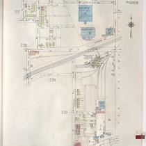
Title
-
Sanborn Map, Kansas City, Vol. 2, 1940-1957, Page p210
-
Description
-
A portion of northeast Kansas City from E. 13th Street south to Truman Road and from Askew Avenue east to Cleveland Avenue, showing buildings, streets, and railroads. Large numbers at edges of page refer to page with adjoining area.
-
Date
-
1940/1957
-
Object Type
-
Map
-
-
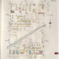
Title
-
Sanborn Map, Kansas City, Vol. 2, 1940-1957, Page p240
-
Description
-
A portion of northeast Kansas City from E. 11th Street south to Truman Road and from Jackson Avenue east to Elmwood Avenue, showing buildings, streets, and railroad lines. Large numbers at edges of pages refer to page with adjoining area.
-
Date
-
1940/1957
-
Object Type
-
Map
-

-
Title
-
Sanborn Map, Kansas City, Vol. 2, 1940-1957, Page p208
-
Description
-
A portion of northeast Kansas City from E. 13th Street south to Truman Road and from Benton Boulevard east to Indiana Avenue, showing buildings and streets. Large numbers at edges of page refer to page with adjoining area.
-
Date
-
1940/1957
-
Object Type
-
Map
-

-
Title
-
Sanborn Map, Kansas City, Vol. 2, 1940-1957, Page p239
-
Description
-
A portion of northeast Kansas City from E. 13th Street south to Truman Road and from Jackson Avenue east to Kensington Avenue, showing buildings, streets, and railroad lines. Large numbers at edges of pages refer to page with adjoining area.
-
Date
-
1940/1957
-
Object Type
-
Map
-
-
Title
-
Sanborn Map, Kansas City, Vol. 2, 1940-1957, Page p238
-
Description
-
A portion of northeast Kansas City from E. 11th Street south to Truman Road and from Cleveland Avenue east to Spruce Avenue, showing buildings, streets, and railroad lines. Large numbers at edges of pages refer to page with adjoining area.
-
Date
-
1940/1957
-
Object Type
-
Map
-

-
Title
-
Sanborn Map, Kansas City, Vol. 2, 1940-1957, Page p201
-
Description
-
A portion of northeast Kansas City from E. 14th Street south to E. 15th Street (Truman Road) and from Woodland Avenue east to Garfield Avenue, showing buildings, streets, and parking areas. Large numbers at edges of page refer to pages with adjoining area.
-
Date
-
1940/1957
-
Object Type
-
Map
-

-
Title
-
Sanborn Map, Kansas City, Vol. 2, 1940-1957, Page p206
-
Description
-
A portion of northeast Kansas City from E. 13th Street south to Truman Road and from Chestnut Avenue east to Agnes Avenue, showing buildings and streets. Large numbers at edges of page refer to page with adjoining area.
-
Date
-
1940/1957
-
Object Type
-
Map
-
-
Title
-
Sanborn Map, Kansas City, Vol. 2, 1940-1957, Page p205
-
Description
-
A portion of northeast Kansas City from E. 13th Street south to Truman Road and from Prospect Avenue east to Chestnut Avenue, showing buildings and streets. Large numbers at edges of page refer to page with adjoining area.
-
Date
-
1940/1957
-
Object Type
-
Map
-

-
Title
-
Sanborn Map, Kansas City, Vol. 2, 1940-1950, Page p201
-
Description
-
A portion of northeast Kansas City from E. 14th Street south to E. 15th Street (Truman Road) and from Woodland Avenue east to Garfield Avenue, showing buildings, streets, and parking areas. Large numbers at edges of page refer to pages with adjoining area. (This volume begins with page 201.)
-
Date
-
1940/1950
-
Object Type
-
Map
-
-
Title
-
Sanborn Map, Kansas City, Vol. 2, 1940-1950, Page p202
-
Description
-
A portion of northeast Kansas City from E. 14th Street south to Truman Road (15th Street) and from the Paseo east to Woodland Avenue, showing buildings and streets. Large numbers at edge of page refer to pages with adjoining area.
-
Date
-
1940/1950
-
Object Type
-
Map
-

-
Title
-
Sanborn Map, Kansas City, Vol. 2, 1940-1950, Page p203
-
Description
-
A portion of northeast Kansas City from E. 14th Street south to Truman Road and from Garfield Avenue east to Olive Street, showing buildings and streets. Large numbers at edge of page refer to pages with adjoining area.
-
Date
-
1940/1950
-
Object Type
-
Map
-

-
Title
-
Sanborn Map, Kansas City, Vol. 2, 1940-1950, Page p238
-
Description
-
A portion of northeast Kansas City from E. 11th Street south to Truman Road and from Cleveland Avenue east to Spruce Avenue, showing buildings, streets, and railroad lines. Large numbers at edges of pages refer to page with adjoining area.
-
Date
-
1940/1950
-
Object Type
-
Map
-

-
Title
-
Sanborn Map, Kansas City, Vol. 2, 1940-1950, Page p208
-
Description
-
A portion of northeast Kansas City from E. 13th Street south to Truman Road and from Benton Boulevard east to Indiana Avenue, showing buildings and streets. Large numbers at edges of page refer to page with adjoining area.
-
Date
-
1940/1950
-
Object Type
-
Map
-

-
Title
-
Sanborn Map, Kansas City, Vol. 2, 1940-1950, Page p207
-
Description
-
A portion of northeast Kansas City from E. 13th Street south to Truman Road and from Agnes Avenue east to Benton Boulevard, showing buildings and streets. Large numbers at edges of page refer to page with adjoining area.
-
Date
-
1940/1950
-
Object Type
-
Map
Pages
