-

-
Title
-
Sanborn Map, Kansas City, Vol. 2, 1909-1937, Page p213
-
Description
-
A portion of Kansas City from E. 8th Street south to E. 11th Street and from Holmes east to Campbell, showing buildings, streets, and additions. Large numbers at edges of page refer to page with adjoining area.
-
Date
-
1909/1937
-
Object Type
-
Map
-

-
Title
-
Sanborn Map, Kansas City, Vol. 2, 1909-1937, Page p231
-
Description
-
A portion of Kansas City from E. 11th Street south to E. 13th Street and from Charlotte Street east to Harrison Street, showing buildings, streets, and additions. Large numbers at edges of page refer to page with adjoining area.
-
Date
-
1909/1937
-
Object Type
-
Map
-

-
Title
-
Sanborn Map, Kansas City, Vol. 2, 1909-1937, Page p232
-
Description
-
A portion of Kansas City from E. 11th Street south to E. 13th Street and from Harrison Street east to Forest Avenue, showing buildings, streets, and additions. Large numbers at edges of page refer to page with adjoining area.
-
Date
-
1909/1937
-
Object Type
-
Map
-

-
Title
-
Sanborn Map, Kansas City, Vol. 2, 1909-1937, Page p230
-
Description
-
A portion of Kansas City from E. 11th Street south to E. 13th Street and from Cherry Street east to Charlotte Street, showing buildings, streets, and additions. Large numbers at edges of page refer to page with adjoining area.
-
Date
-
1909/1937
-
Object Type
-
Map
-

-
Title
-
Sanborn Map, Kansas City, Vol. 2, 1909-1937, Page p214
-
Description
-
A portion of Kansas City from E. 8th Street south to E. 11th Street and from Harrison Street east to Forest Avenue, showing buildings, streets, and additions. Large numbers at edges of page refer to page with adjoining area.
-
Date
-
1909/1937
-
Object Type
-
Map
-
-
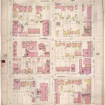
Title
-
Sanborn Map, Kansas City, Vol. 2, 1896-1907, Page p135
-
Description
-
Northeastern part of early Kansas City from E. 10th Street south to E. 12th Street and from Holmes Street east to Harrison Street, showing buildings, streets, and additions. Large numbers at edges of page refer to page with adjoining area.
-
Date
-
1896/1907
-
Object Type
-
Map
-

-
Title
-
Sanborn Map, Kansas City, Vol. 2, 1896-1907, Page p134
-
Description
-
Northeastern part of early Kansas City from E. 8th Street south to E. 10th Street and from Holmes Street east to Harrison Street, showing buildings, streets, and additions.
-
Date
-
1896/1907
-
Object Type
-
Map
-

-
Title
-
Sanborn Map, Kansas City, Vol. 2, 1896-1907, Page p144
-
Description
-
Northeastern part of early Kansas City from E. 8th Street south to E. 10th Street and from Harrison Street east to Tracy Avenue, showing buildings, streets, and additions. Large numbers at edges of page refer to page with adjoining area.
-
Date
-
1896/1907
-
Object Type
-
Map
