-

-
Title
-
A New Map of the State of Iowa
-
Description
-
Map showing all four boundaries of the state of Iowa. Includes all of the counties in the state and portions of Nebraska, Missouri, Minnesota, and Illinois. Number "35" printed on the lower right corner.
-
Date
-
1856
-
Object Type
-
Map
-

-
Title
-
Iowa
-
Description
-
Map of Iowa showing all four bondaries of the state. Includes counties and portions of Minnesota, Nebraska, Missouri, Illinois, and Wisconsin. "No. 47" is printed on the lower right corner.
-
Date
-
1855
-
Object Type
-
Map
-

-
Title
-
Colton's New Map of Missouri
-
Description
-
Continuation of title: "Compiled from the U.S. Surveys, and other authentic sources." Map of Missouri with counties shown in color with township and range lines. Also shows towns, roads, canals, mills, mines, and railroads finished and proposed. Some towns and Indian territory indicated for eastern Kansas.
-
Date
-
1857
-
Object Type
-
Map
-

-
Title
-
Map of the State of Iowa
-
Description
-
Map showing all four boundaries of the state of Iowa and fifty counties located in the east and south sections of the state. Adjacent portions of Wisconsin, Illinois, Missouri, Indian Territory, and Minnesota also shown.
-
Date
-
1850
-
Object Type
-
Map
-

-
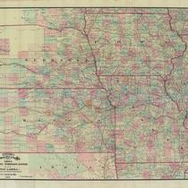
Title
-
Colton's New Sectional Map of the State of Missouri
-
Description
-
Continuation of title: Compiled from the United States Surveys and Other Authentic Sources Exhibiting the Sections, Fractional Sections, Counties, Cities, Towns, Villages, Post Offices, Rail Roads & other Internal Improvements. Map of Missouri with counties shown in color with township and range lines. Also shows towns, roads, canals, mills, mines, and railroads finished and proposed. Some towns and Indian territory indicated for eastern Kansas.
-
Date
-
1872
-
Object Type
-
Map
-

-
Title
-
MacLean and Lawrence's Sectional Map of Kansas Territory
-
Description
-
Continuation of title: Compiled from the U.S. Surveys by C. P. Wiggin.Photocopy of a map of Kansas Territory including the counties of Leavenworth, Johnson, Lykins, Franklin, Douglass, Jefferson, and Atchison. Shows Indian reservations, some towns and roads, with townships and ranges noted.
-
Date
-
1857-04
-
Object Type
-
Map