-

-
Title
-
Extension of City Limits Kansas City MO, At Different Periods
-
Description
-
Map identifying the areas annexed by the city of Kansas City, Missouri, in the years 1853, 1859, 1875, 1885, 1897, and 1909. The city limits in 1909 were the Missouri River south to 79th Street, and State Line Road east as far as Booth Avenue.
-
Date
-
1909
-
Object Type
-
Map
-

-
Title
-
Kansas City Metropolitan Area
-
Description
-
Black and white map of Kansas City and surrounding communities shows highways and roads, railroads, section lines, towns, townships, county and state lines, parks, streams, and rivers.
-
Date
-
2009
-
Object Type
-
Map
-

-
Title
-
The Berry Company's Map of Kansas City
-
Description
-
Map of Kansas City, Missouri, indicating streets, hospitals, schools, and owners of land plots, south as far as 83rd St., east to just beyond the Blue River. Map cover includes post office hours, names and addresses of office buildings as well as city, county, and federal buildings, libraries and reading rooms, theaters, and parks.
-
Date
-
1912
-
Object Type
-
Map
-
-
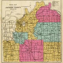
Title
-
Road Map of Jackson County, Missouri
-
Description
-
Road map of Jackson County, Missouri, including the city of Kansas City and townships of Washington, Prairie, Van Buren, Sniabar, Fort Osage, Brooking, and Blue. Includes hard surface roads, graded roads, oiled roads, earth roads, railroads, electric lines, streams, old trails, and schools and churches. Handwritten notes from unknown source on front and back of map, labeling and other notes.
-
Object Type
-
Map
-

-
Title
-
Showdown at State Line
-
Description
-
While competition for economic development is cordially fierce on either side of State Line, cooperation is almost too good to be believed.
-
Date
-
2000-10
-
Object Type
-
Magazine Article
-

-
Title
-
Map of Jackson County, Missouri
-
Description
-
Map of Jackson County, Missouri, depicting roads (graded, rock, county), railroads, streams, schools, and churches. Includes townships of Blue, Brooking, Washington, Prairie, Van Buren, Sni-a-bar, and Fort Osage, and cities of Kansas City and Independence. Also includes major farms: Walton-Holmes, Minor, F. G. Robinson, Belvedere, W. D. Johnson, Longview, Malvern Land Co., Blackwell, Barzen, J. C. Knopp, Alexander, King, La Cima, Fields, Yost, Velie, Sni-a-bar, Andrew Drumm, Swinney, and McCoy.
-
Date
-
1917
-
Object Type
-
Map
-
![Thaxter's Map of the Two Kansas Citys [sic] of Missouri and Kansas](https://kchistory.org/sites/default/files/styles/islandora_imagecache_image_style_medium/public/externals/8b05940a47a4e406f9f68682bf90e68f.jpg?itok=tn2YrC-U&pid=kchistory:106613&iic=true&solr_nav%5Bid%5D=c6e16bffc61b5a03038c&solr_nav%5Bpage%5D=0&solr_nav%5Boffset%5D=6)
-
Title
-
Thaxter's Map of the Two Kansas Citys [sic] of Missouri and Kansas
-
Description
-
Street map of Kansas City, Missouri, and Kansas City, Kansas. Names of principal streets shown. Also shows parks, cemeteries, schools, railroad, cable car, and electric train lines as well as Quindaro and Argentine, Kansas, and Randolph and Harlem, Missouri.
-
Date
-
1890
-
Object Type
-
Map
-

-
Title
-
Wright's Map of Kansas City
-
Description
-
Detailed map of Kansas City, Missouri, that includes roads, railroads, subdivisions and additions, and some property owners. Subdivisions have been colored by an unknown source after the map was printed. A portion of Wyandotte County is also included.
-
Date
-
1884
-
Object Type
-
Map
