-
-
Title
-
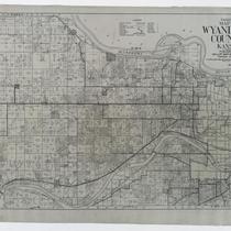
Gallup's Map of Wyandotte County, Kansas
-
Description
-
Land ownership map of Wyandotte County, Kansas, showing county roads, roads, railroads, electric railroads, schools, churches, cemeteries, streams, and township boundaries, as well as drilling, oil, gas, dry, and abandoned wells. Includes the townships of Prairie, Quindaro, Wyandotte, Delaware, and Shawnee.
-
Date
-
1923
-
Object Type
-
Map
-

-
Title
-
Bates CO. Missouri
-
Description
-
Map of Bates County, Missouri, that includes paved roads, graveled roads, state or county roads not highly improved, roads, interstates and highways, railroads, drainage district line, municipal township lines, streams, and schools. Includes the townships of West Boone, East Boone, Deer Creek, Grand River, Mingo, West Point, Elkhart, Mound, Shawnee, Spruce, Homer, Charlotte, Mount Pleasant, Summit, Deepwater, Walnut, New Home, Lone Oak, Pleasant Gap, Hudson, Howard, Osage, Prairie, and Rockville.
-
Object Type
-
Map
-
-
Title
-
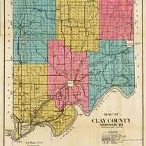
Map of Clay County Missouri
-
Description
-
Map of Clay County, Missouri, including railroads, electric lines, roads, schools, churches, and airports. Includes townships of Platte, Kearney, Washington, Gallatin, Liberty, and Fishing River. Includes cities of Liberty, Excelsior Springs, and North Kansas City. Also includes Kansas City Co. & St. Joe Electric Line.
-
Object Type
-
Map
-

-
Title
-
Road Map of Jackson County, Missouri
-
Description
-
Road map of Jackson County, Missouri, that includes roads, railroads, electric lines, sections lines, streams, township lines, old trails, schools, and churches. Legend indicates types of roads shown. Includes townships of Blue, Fort Osage, Brooking, Sni-a-bar, Washington, Prairie, and Van Buren.
-
Object Type
-
Map
-

-
Title
-
Johnson County, Missouri
-
Description
-
Map of Johnson County, Missouri, that includes highways, county roads, township roads, political township lines, railroads, drainage ditches, streams, and schools. Included are townships Jackson, Columbus, Hazel Hill, Simpson, Grover, Kingsville, Madison, Centerview, Warrensburg, Washington, Montserrat, Rose Hill, Chilhowee, Post Oak, and Jefferson.
-
Object Type
-
Map
-
![Map of Cass County, Mo. [Southern Section]](https://kchistory.org/sites/default/files/styles/islandora_imagecache_image_style_medium/public/externals/0f24d14bdc37d350cece388889339b08.jpg?itok=8FOOtRg_&pid=kchistory:106281&iic=true&solr_nav%5Bid%5D=d3fa200de5b0f0d5a613&solr_nav%5Bpage%5D=0&solr_nav%5Boffset%5D=5)
-
Title
-
Map of Cass County, Mo. [Southern Section]
-
Description
-
Land ownership map of Cass County, Missouri, showing paved and graveled roads, schools and school district boundaries, railroads, section lines, twp.& range lines, streams, cemeteries, houses, and churches. Includes the southern Cass County townships of West Dolan, Dolan, Grand River, Camp Branch, Index, Cold Water, Everett, Austin, Dayton, and Sherman.
-
Object Type
-
Map
-
![Map of Cass County, Mo. [Northern Section]](https://kchistory.org/sites/default/files/styles/islandora_imagecache_image_style_medium/public/externals/babbf0d2e9bc527adc02442ccdcf7e70.jpg?itok=MnApPT7k&pid=kchistory:106282&iic=true&solr_nav%5Bid%5D=d3fa200de5b0f0d5a613&solr_nav%5Bpage%5D=0&solr_nav%5Boffset%5D=6)
-
Title
-
Map of Cass County, Mo. [Northern Section]
-
Description
-
Land ownership map of Cass County, Missouri, showing paved and graveled roads, schools and school district boundaries, railroads, section lines, twp.& range lines, streams, cemeteries, houses, and churches. Includes the northern Cass County townships of Mount Pleasant, Raymore, Big Creek, Pleasant Hill, Polk, Union, West Peculiar and Peculiar.
-
Object Type
-
Map
-

-
Title
-
Zoning Map, Kansas City, Missouri
-
Description
-
Kansas City, Missouri, color-coded zoning map of nine zone classifications, including residence, retail, and industrial zones. "Information taken from city ordinance No. 45608 and the latest official data of City Plan Commission."
-
Date
-
1923
-
Object Type
-
Map
-

-
Title
-
Jackson County, Missouri
-
Description
-
Map shows roads, railroad lines, schools, and political township lines of Jackson County, Missouri, and also shows proposed enlarged school districts, with some school districts unchanged.
-
Date
-
1920
-
Object Type
-
Map
-

-
Title
-
Road Map of Jackson County, Missouri
-
Description
-
Road map of Jackson County, Missouri, including the city of Kansas City and townships of Washington, Prairie, Van Buren, Sniabar, Fort Osage, Brooking, and Blue. Includes hard surface roads, graded roads, oiled roads, earth roads, railroads, electric lines, streams, old trails, and schools and churches. Handwritten notes from unknown source on front and back of map, labeling and other notes.
-
Object Type
-
Map
-

-
Title
-
Jackson County, Missouri
-
Description
-
Land ownership map of Jackson County, Missouri, showing roads (hard surfaced, oiled dirt, and graded), state highways, U.S. interstates, railroads (steam and electric), municipal township lines, schools, churches, streams, oil wells, gas wells, and dry holes. Includes the townships of Blue, Fort Osage, Sni A Bar, Brooking, and Washington.
-
Date
-
1927
-
Object Type
-
Map
-

-
Title
-
Jackson County, Missouri
-
Description
-
Land ownership map of Jackson County, Missouri, showing railroads (steam and electric), roads (rock, oiled, graded), schools, churches, streams, oil wells, gas wells, and dry holes. Includes townships of Blue, Fort Osage, Sni A Bar, Brooking, and Washington.
-
Date
-
1920~
-
Object Type
-
Map
