-

-
Title
-
Kansas City, Missouri
-
Description
-
Street map of Kansas City showing parks, cemeteries, park district boundaries, and street car lines.
-
Date
-
1910
-
Object Type
-
Map
-

-
Title
-
War Incidents at Kansas City
-
Description
-
Reminiscences of Daniel Geary regarding Civil War activities in Kansas City and surrounding areas. Description of Geary, born in New York in 1835 and coming to Kansas City about 1856, appointed city engineer and then provost marshall by General Thomas Ewing "with headquarters at the old Pacific Hotel" at 4th and Delaware Streets. Descriptions of various events and Kansas Citians, including Robert Hunt, George Todd, Major Robert Van Horn, John Edwards, Wild Bill Hickok, and Morrson Munford, et al.
-
Date
-
1910
-
Object Type
-
Magazine Article
-

-
Title
-
Addenda
-
Description
-
Map and notes about the proposed (by Colonel Robert Van Horn in the 19th century) but never enacted change of the state boundary between Kansas and Missouri through Kansas City (along the Big Blue River).
-
Date
-
1910
-
Object Type
-
Magazine Article
-
![The Boundary Lines of Kansas [and] The East Boundary Line of Kansas](https://kchistory.org/sites/default/files/styles/islandora_imagecache_image_style_medium/public/Magazine_KcHistory_icon_square_0.png?itok=U0aupZ0s&pid=kchistory:79566&iic=true&solr_nav%5Bid%5D=71dced05b831319e8c57&solr_nav%5Bpage%5D=0&solr_nav%5Boffset%5D=3)
-
Title
-
The Boundary Lines of Kansas [and] The East Boundary Line of Kansas
-
Description
-
Photos, map, and articles about the development of boundary lines for the territory and state of Kansas since the formation of the state of Missouri in 1820, with descriptions of Kansas's eastern boundary at the mouth of the Kansas River projected south through Kansas City, etc.
-
Date
-
1910
-
Object Type
-
Magazine Article
-
-
Title
-
Map of Randolph CO. MO.
-
Description
-
Map of Randolph County, Missouri, that includes roads, steam railroads, streams, schools, churches, and cemeteries. Includes the townships of Chariton, Jackson, Salt River, Clifton, Salt Spring, Cairo, Union, Sugar Creek, Silver Creek, Moniteau, and Prairie.
-
Date
-
1910
-
Object Type
-
Map
-
-
Title
-
Map of Lewis CO. MO.
-
Description
-
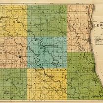
Map of Lewis County, Missouri, that includes schools, churches, cemeteries, roads, railroads, and streams. Includes the townships of Reddish, Lyon, Canton, La Belle, Dickerson, Salem, Highland, and Union.
-
Date
-
1910
-
Object Type
-
Map
-

-
Title
-
Map of Scotland CO. MO.
-
Description
-
Map of Scotland County, Missouri, that includes schools, churches, cemeteries, roads, railroads, and streams. Includes the townships of Miller, Union, Johnson, Vest, Jefferson, Thomson, Mt. Pleasant, Tobin, Sand Hill, and Harrison. Handwriiten notes identify schools and possibly teachers at some schools.
-
Date
-
1910
-
Object Type
-
Map
-

-
Title
-
Map of Carroll Co. Mo.
-
Description
-
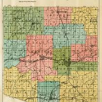
Map of Carroll County, Missouri, including roads, railroads, streams, schools, churches, and cemeteries. Includes city of Carrollton, and townships of Washington, Fairfield, Prairie, Egypt, Cherry Valley, Sugar Tree, Moss, Trotter, Leslie, Hill, Stokes Mound, Van Horn, Carrollton, Wakenda, Eugene, Combs, Ridge, Hurricane, Rock Ford, Dewitt, Miami, and Smith.
-
Date
-
1910
-
Object Type
-
Map
-
-
Title
-
Map of Monroe CO. MO.
-
Description
-
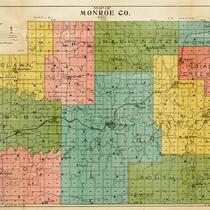
Map of Monroe County, Missouri, that includes schools, churches, cemeteries, roads, railroads, and streams. Includes the townships of Woodlawn, Clay, Washington, Monroe, Marion, Union, Jackson, Indian Creek, Jefferson, and South Fork.
-
Date
-
1910
-
Object Type
-
Map
-

-
Title
-
Map of Audrain CO. MO.
-
Description
-
Map of Audrain County, Missouri, that includes roads, steam railroads, streams, churches, cemeteries, and schools. Includes the townships of Saling, Wilson, Salt River, Prarie, Linn, Loutre, and Cuivre. Handwritten notes identify possible owners of property and names of schools.
-
Date
-
1910
-
Object Type
-
Map
-

-
Title
-
Map of Schuyler CO. MO.
-
Description
-
Map of Schuyler County, Missouri, that includes roads, railroads, schools, churches, cemeteries,and streams. Includes the townships of Chariton, Liberty, Fabius, Glenwood, Prairie, Independence, and Salt River. Handwritten notes possibly identify the owners of property, schools, and churches.
-
Date
-
1910
-
Object Type
-
Map
-

-
Title
-
Map of Audrain CO. MO.
-
Description
-
Map of Audrain County, Missouri, that includes roads, railroads, streams, churches, cemeteries, and schools. Includes the townships of Saling, Wilson, Salt River, Prairie, Loutre, Linn, and Cuivre. Includes the city of Mexico.
-
Date
-
1910
-
Object Type
-
Map
-

-
Title
-
Map of Gentry CO. MO.
-
Description
-
Map of Gentry County, Missouri, that includes schools, churches, cemeteries, roads, railroads, and streams. Includes the townships of Wilson, Bogle, Howard, Cooper, Huggins, Athens, Jackson, and Miller.
-
Date
-
1910
-
Object Type
-
Map
