Pages
-

-
Title
-
1922 Road Map of Jackson County, Missouri
-
Description
-
Map showing roads in Jackson County, Missouri. Legend indicates type of road (macadam, graded, etc.). Section lines, electric lines, railroad lines, and streams are also shown. Only a few major roads in Kansas City are identified.
-
Date
-
1922
-
Object Type
-
Map
-

-
Title
-
1931 Road Map of Jackson County, Missouri
-
Description
-
Map showing roads in Jackson County, Missouri. Legend indicates kind of road (macadam, graded, etc.). Section lines, electric lines, railroad lines, schools, and streams are also shown. Only a few major roads in Kansas City are identified. Shows townships and ranges.
-
Date
-
1931
-
Object Type
-
Map
-

-
Title
-
Addenda
-
Description
-
Map and notes about the proposed (by Colonel Robert Van Horn in the 19th century) but never enacted change of the state boundary between Kansas and Missouri through Kansas City (along the Big Blue River).
-
Date
-
1910
-
Object Type
-
Magazine Article
-

-
Title
-
Bates CO. Missouri
-
Description
-
Map of Bates County, Missouri, that includes paved roads, graveled roads, state or county roads not highly improved, roads, interstates and highways, railroads, drainage district line, municipal township lines, streams, and schools. Includes the townships of West Boone, East Boone, Deer Creek, Grand River, Mingo, West Point, Elkhart, Mound, Shawnee, Spruce, Homer, Charlotte, Mount Pleasant, Summit, Deepwater, Walnut, New Home, Lone Oak, Pleasant Gap, Hudson, Howard, Osage, Prairie, and Rockville.
-
Object Type
-
Map
-

-
Title
-
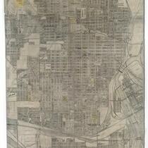
The Berry Company's Map of Kansas City
-
Description
-
Map of Kansas City, Missouri, indicating streets, hospitals, schools, and owners of land plots, south as far as 83rd St., east to just beyond the Blue River. Map cover includes post office hours, names and addresses of office buildings as well as city, county, and federal buildings, libraries and reading rooms, theaters, and parks.
-
Date
-
1912
-
Object Type
-
Map
-
-
Title
-
The Berry Company's Map of Kansas City, Kansas
-
Description
-
Land ownership map of the city of Kansas City, Kansas, showing steam and electric railways, parks, schools, cemeteries, businesses, and municipal buildings and landmarks.
-
Date
-
1910~
-
Object Type
-
Map
-
![The Boundary Lines of Kansas [and] The East Boundary Line of Kansas](https://kchistory.org/sites/default/files/styles/islandora_imagecache_image_style_medium/public/Magazine_KcHistory_icon_square_0.png?itok=U0aupZ0s&pid=kchistory:79566&iic=true&solr_nav%5Bid%5D=441a9e6ae475dc88ca4d&solr_nav%5Bpage%5D=0&solr_nav%5Boffset%5D=7)
-
Title
-
The Boundary Lines of Kansas [and] The East Boundary Line of Kansas
-
Description
-
Photos, map, and articles about the development of boundary lines for the territory and state of Kansas since the formation of the state of Missouri in 1820, with descriptions of Kansas's eastern boundary at the mouth of the Kansas River projected south through Kansas City, etc.
-
Date
-
1910
-
Object Type
-
Magazine Article
-

-
Title
-
Buchanan County, Missouri
-
Description
-
Land ownership map of Buchanan County, Missouri, showing highways, paved and graveled roads, civil and political TWP lines, railroads, schools, churches, cemeteries, and streams. Includes the townships of Washington, Marion, Wayne, Center, Agency, Tremont, Rush, Bloomington, Crawford, Jackson, and Platte.
-
Date
-
1940~
-
Object Type
-
Map
-

-
Title
-
Buchanan County, Missouri Map
-
Description
-
Land ownership map of Buchanan County, Missouri including the townships of Washington, Marion, Lake, Wayne, Center, Agency, Tremont, Rush, Bloomington, Crawford, Jackson, and Platte. Includes a key for "conventionals" such as roads, auto roads, railroads, railroads (electric), streams, schools. churches, and cemeteries.
-
Date
-
1920~
-
Object Type
-
Map
-

-
Title
-
Clay County Missouri
-
Description
-
Detailed map of Clay County, Missouri depicts county and city boundaries, interstates, state, and county highways, as well as many primary and secondary surface streets within particular localities. Also noted are parks, schools, hospitals, and townships. Of particular note is an illustration of the proposed site of the Smithville Reservoir in northern Clay County, which in 1979 became Smithville Lake.
-
Date
-
1965
-
Object Type
-
Map
-

-
Title
-
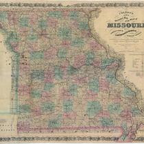
Colton's New Map of Missouri
-
Description
-
Continuation of title: "Compiled from the U.S. Surveys, and other authentic sources." Map of Missouri with counties shown in color with township and range lines. Also shows towns, roads, canals, mills, mines, and railroads finished and proposed. Some towns and Indian territory indicated for eastern Kansas.
-
Date
-
1857
-
Object Type
-
Map
-
-
Title
-
Colton's New Sectional Map of the State of Missouri
-
Description
-
Continuation of title: Compiled from the United States Surveys and Other Authentic Sources Exhibiting the Sections, Fractional Sections, Counties, Cities, Towns, Villages, Post Offices, Rail Roads & other Internal Improvements. Map of Missouri with counties shown in color with township and range lines. Also shows towns, roads, canals, mills, mines, and railroads finished and proposed. Some towns and Indian territory indicated for eastern Kansas.
-
Date
-
1872
-
Object Type
-
Map
-

-
Title
-
County and Township: New Bi-State Agency Planned
-
Description
-
Description of the creation of the "Mo-Kan Metropolitan Development District," comprising eight counties by the state legislatures.
-
Date
-
1957-05
-
Object Type
-
Magazine Article
-

-
Title
-
Diagram of the State of Missouri
-
Description
-
Map of Missouri marked off into blocks of land, each six miles square, known as townships. Symbols indicate whether or not the townships have been subdivided by surveyors. Names of contracted surveyors may be found in the text accompanying map. Lead, iron, copper, and coal mines are indicated, as well as salt works. Watersheds shown in detail. Survey of the southern boundary of the state is given extra attention, as is the old Indian boundary line commonly called Sullivan's line on the north. Fourth in a series of four maps showing the progress of surveys in Missouri.
-
Date
-
1851
-
Object Type
-
Map
-

-
Title
-
Diagram of the State of Missouri
-
Description
-
Map of Missouri marked off into blocks of land, each six miles square, known as townships. Symbols indicate whether or not the townships have been subdivided by surveyors. Lead, iron, copper, coal mines are indicated, as well as salt works. Third in a series of four maps showing the progress of surveys in Missouri.
-
Date
-
1845
-
Object Type
-
Map
-

-
Title
-
Diagram of the State of Missouri
-
Description
-
Map of Missouri showing large areas marked off into six mile square blocks of land known as townships. Symbols indicate whether or not the townships have been subdivided by surveyors. Second in a series of four maps showing the progress of surveys in Missouri.
-
Date
-
1841
-
Object Type
-
Map
Pages

