-

-
Title
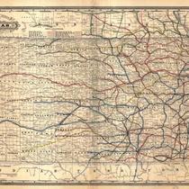
-
Base Map of Missouri
-
Description
-
Map of Missouri including railroad lines, cities over 5,000, counties and county seats, and elevations.
-
Date
-
1940
-
Object Type
-
Map
-

-
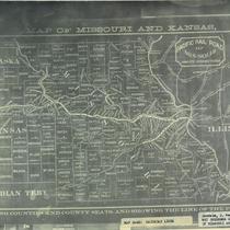
Title
-
Watson's New County, Railroad, and Distance Map of Missouri
-
Description
-
Map of Missouri showing counties, county seats, other towns, completed railroad lines with stops, proposed rail lines, and canals. Map also includes a portion of western Kansas, extreme northern Arkansas, and extreme eastern Illinois.
-
Date
-
1875
-
Object Type
-
Map
-

-
Title
-
Plan of the City of Leavenworth, Kansas
-
Description
-
Map of Leavenworth including a numbered guide with city and county offices, railroad buildings, hotels, schools, and churches.
-
Date
-
1876
-
Object Type
-
Map
-

-
Title
-
Base Map of Missouri
-
Description
-
Map of Missouri including railroad lines, cities over 5,000, counties and county seats, and elevations.
-
Date
-
1914
-
Object Type
-
Map
-

-
Title
-
Princeton, Kansas
-
Description
-
Item relating the story of Princeton, Kansas, a townsite once existing two miles southwest of Olathe. In an election to determine the county seat of Johnson County, Princeton lost to Olathe due to the fact that "the Shawnee Indians were declared legal voters for this occasion and their votes were almost solid for Olathe".
-
Date
-
1905-03-29
-
Object Type
-
Book
-

-
Title
-
The Good, the Bad, and the Ugly
-
Description
-
Discusses the process by which towns in Kansas were chosen to be county seats.
-
Date
-
2000
-
Object Type
-
Magazine Article
-

-
Title
-
State of Missouri
-
Description
-
Map of Missouri including United States Land offices, county seats, principal railroad stations, roads, etc.
-
Date
-
1878
-
Object Type
-
Map