-

-
Title
-
E. F. Swinney School Buidling
-
Description
-
Street view of the E. F. Swinney School located on W. 47th Street, between Holly Street and West Prospect Place, later named Jarboe Street. School named for Edward F. Swinney, treasurer of the Board of Education, 1894 to 1904.
-
Object Type
-
Photograph
-

-
Title
-
E. F. Swinney School Building
-
Description
-
Street view of E. F. Swinney School building located at W. 47th Street and West Prospect Place, later renamed Jarboe Street.
-
Object Type
-
Photograph
-

-
Title
-
Westport Homeowners Receive Solar Grants
-
Description
-
Drawing of a school building's solar hot water heating system, among examples of solar energy grants in Westport funded by the Hallmark Educational Foundation.
-
Date
-
1979-10
-
Object Type
-
Magazine Article
-

-
Title
-
E.F. Swinney School Building
-
Description
-
Exterior view of the E. F. Swinney Public School at W. 47th and West Prospect Place (Jarboe). It was also the location of the Swinney Branch Library.
-
Object Type
-
Photograph
-

-
Title
-
Children at the Swinney Branch Library
-
Description
-
Children seated at tables inside the Swinney Branch Library, located inside the E. F. Swinney Public School on W. 47th Street, between Holly and West Prospect Place (Jarboe).
-
Date
-
1915
-
Object Type
-
Photograph
-

-
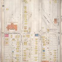
Title
-
Sanborn Map, Kansas City, Vol. 6, 1917-1957, Page p795
-
Description
-
A portion of western Kansas City from W. 46th Street south to W. 48th Street and from Holly Street east to Roanoke Parkway, showing buildings, streets, and additions. Large numbers at edges of page refer to page with adjoining area.
-
Date
-
1917/1957
-
Object Type
-
Map
-

-
Title
-
Aerial View of Kansas City, Missouri
-
Description
-
Aerial photograph of one square mile of Kansas City, Missouri showing the area west of the Plaza, including the Swinney Area. Map identified from set as Section 30, Township 49N, Range 33W, S-78.
-
Date
-
1964-04
-
Object Type
-
Map
-
-
Title
-
Sanborn Map, Kansas City, Vol. 6, 1917-1945, Page p795
-
Description
-
A portion of western Kansas City from W. 46th Street south to W. 48th Street and from Holly Street east to Roanoke Parkway, showing buildings, streets, and additions. Large numbers at edges of page refer to page with adjoining area.
-
Date
-
1917/1945
-
Object Type
-
Map
-

-
Title
-
'Sad, Sad Day'--21 KC Schools Close Down
-
Description
-
Article describes 21 schools in the Kansas City School District that will close as a first step in the district's improvement plan. Includes a two-page tribute to the schools being closed including Westport High School, Central Academy, and Ladd Elementary.
-
Date
-
2010-06-04
-
Object Type
-
Newspaper Article


