Pages
-

-
Title
-
Heim Brewery
-
Description
-
Picture of bottling works at Heim's Brewery.
-
Date
-
1902
-
Object Type
-
Book Section
-

-
Title
-
Electric Park
-
Description
-
Picture of the entrance of Heim Electric Park, East Bottoms.
-
Date
-
1902
-
Object Type
-
Book Section
-

-
Title
-
Verdi Banta
-
Description
-
Biographical sketch of Verdi Banta, "manager of the Heim Brewery," after having "spent all his life in Kansas City," starting his career as a postal carrier at the Federal Building and then postmaster of Westport, appointed by President Harrison, then appointed sheriff before moving to the Ferd Heim Brewery.
-
Date
-
1908
-
Object Type
-
Book Section
-

-
Title
-
Heim Brewery
-
Description
-
Brewery "well-known" in the Midwest for its lager beer, located at 1402 Main Street.
-
Date
-
1886-05
-
Object Type
-
Book
-

-
Title
-
Night in Kansas City
-
Description
-
A small booklet featuring photographs of Kansas City that have been artistically enhanced to create a nighttime effect.
-
Date
-
1912
-
Object Type
-
Book
-

-
Title
-
Kansas City's Carnival
-
Description
-
Article describes a street fair held by Kansas City's leading retail establishments in a five-block bazaar sponsored by Karnival Krewe. It describes the different companies and details their merchant booths that were set up, providing numerous images.
-
Date
-
1899-10
-
Object Type
-
Magazine Article
-

-
Title
-
East View From City Point
-
Description
-
Postcard showing a view facing east from City Point, now known as Scarritt Point.
-
Date
-
1907
-
Object Type
-
Postcard
-
-
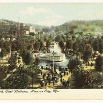
Title
-
Electric Park (1st)
-
Description
-
Postcard of Heim's Electric Park, once located in the East Bottoms area of Kansas City.
-
Object Type
-
Postcard
-

-
Title
-
Electric Park (1st)
-
Description
-
Postcard of Heim's Electric Park in the East Bottoms.
-
Object Type
-
Postcard
-

-
Title
-
Heim Brewery
-
Description
-
Distant view, looking northwest, of East Bottoms location.
-
Object Type
-
Photograph
-
-
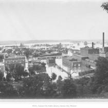
Title
-
Flood Scene
-
Description
-
Distant view of East Bottoms; also shows Ferd Heim Brewing Company and Electric Park.
-
Date
-
1903
-
Object Type
-
Photograph
-

-
Title
-
Heim Brewery
-
Description
-
Distant view of brewery and Electric Park.
-
Date
-
1900
-
Object Type
-
Photograph
-

-
Title
-
Heim Brewery
-
Description
-
Distant view, looking northeast, of brewery and Electric Park from Cliff Drive.
-
Date
-
1905
-
Object Type
-
Photograph
-

-
Title
-
Visitors to Electric Park
-
Description
-
View of a crowd gathered at Electric Park, once located in East Bottoms at Rochester and Montgall avenues. Also shows Ferd Heim Brewing Company.
-
Date
-
1900
-
Object Type
-
Photograph
-

-
Title
-
Ferd. Heim Brewing Company Bottling Plant
-
Description
-
Photograph circa 1980s of the dedication engraving by the construction company, Hucke & Sexton on the westside face of the Ferd. Heim Brewing Company Bottling Plant which reads, "Hucke & Sexton Contracting and Building Co., 318 New York Life Bldg." Construction on the building - designed by Charles A. Smith - was completed in 1901. The building has served as a bottling plant since that time. In 2018, J. Rieger and Company Distillery purchased the building. It was placed on the National Register of Historic Places in 2015. Located in the East Bottoms neighborhood.
-
Date
-
1980~/1989~
-
Object Type
-
Photograph
-

-
Title
-
East Bottoms Looking North from Cliff Drive
-
Description
-
View facing north along Montgall Avenue and Chestnut Trafficway in the East Bottoms from Cliff Drive. The former Ferd. Heim Brewing Company Bottling Plant Building, serving as the home of the Abner Hood Chemical Company when this photograph was captured can be seen. Several cars and trucks are in view. Houses, churches and other East Bottoms industrial buildings can be seen.
-
Date
-
1960~
-
Object Type
-
Photograph
-

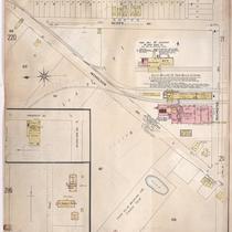
-
Title
-
Sanborn Map, Kansas City, Vol. 2, 1896-1907, Page p214
-
Description
-
Northeastern part of early Kansas City from Rochester Avenue south to Guinotte Avenue and from Propect Avenue east to Chestnut Avenue, showing buildings, streets, and railroad lines. Large numbers at edges of page refer to page with adjoining area.
-
Date
-
1896/1907
-
Object Type
-
Map
-
-
Title
-
Sanborn Map, Kansas City, Vol. 2, 1896-1907, Page p217
-
Description
-
Northeastern part of early Kansas City from Nicholson Avenue south to Rochester Avenue and from Park Avenue east to Scott Avenue, showing buildings, streets, and railroad lines. Large numbers at edges of page refer to page with adjoining area.
-
Date
-
1896/1907
-
Object Type
-
Map
Pages

