Pages
-

-
Title
-
Kansas River
-
Description
-
File containing material pertaining to the Kansas River as it relates to Kansas City.
-
Object Type
-
Vertical File
-

-
Title
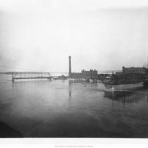
-
1951 Flood
-
Description
-
Aerial view of flooded area, looking north of bridges spanning Kansas River and the stockyards.
-
Date
-
1951
-
Object Type
-
Photograph
-

-
Title
-
Aerial View of Downtown Kansas City and West Bottoms
-
Description
-
Aerial view of downtown Kansas City, the West Bottoms, and the confluence of the Kansas River with the Missouri River looking northwest. No print image; negative and digital only.
-
Object Type
-
Negative
-
-
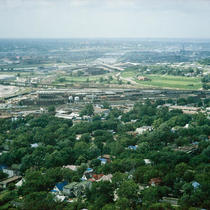
Title
-
Northwest from BMA
-
Description
-
View facing northwest, taken from the BMA Tower, located at 700 W. 31st Street. An industrial area, a portion of the Westside neighborhood, and the Kansas River can be seen.
-
Date
-
1964-06-18
-
Object Type
-
Photograph
-
-
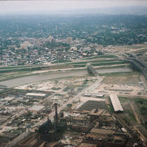
Title
-
West Bottoms - Kansas City, Kansas
-
Description
-
View facing northwest. The West Bottoms, industrial buildings, the James Street Bridge, the Intercity Viaduct, the Kansas River, Strawberry Hill, and the downtown area of Kansas City, Kansas, can be seen.
-
Date
-
1964-05-08
-
Object Type
-
Photograph
-

-
Title
-
Kaw River and Intercity
-
Description
-
View facing northwest taken from the James Street Bridge. The Kansas River, the Intercity Viaduct, and Interstate 70 can be seen.
-
Date
-
1962-09-11
-
Object Type
-
Photograph
-
-
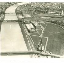
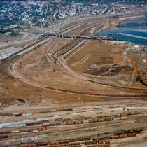
Title
-
Area of the Stockyards and Kaw River
-
Description
-
Area of the Stockyards and the Kaw River between 23rd St. Viaduct and Central Ave, showing buildings including Swift and Co., no date.
-
Object Type
-
Photograph
-

-
Title
-
Report Looks at Causes, Effects of Kansas River's Long Decline
-
Description
-
Article reviews the Kansas Water Office report that is the first comprehensive look at how the river has deteriorated over the years. ''The Kansas River, also known as the Kaw, winds 170 miles from near Manhattan through Topeka and Lawrence before it joins the Missouri.''
-
Date
-
2005-06-02
-
Object Type
-
Newspaper Article
-
-
Title
-
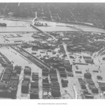
Flooded Area
-
Description
-
Aerial view of submerged West Bottoms area in the aftermath of the 1951 Flood.
-
Date
-
1951
-
Object Type
-
Photograph
-

-
Title
-
West Bottoms during 1951 Flood
-
Description
-
Aerial view of a flooded area in the West Bottoms after the 1951 Flood. Shows Sunshine Biscuits Building, Rudy-Patrick Seeds-Feeds, Weber Paper Company, Couch Tractor & Equipment Co., and the Kansas City Southern Freight House.
-
Date
-
1951
-
Object Type
-
Photograph
-

-
Title
-
Kaw River, River Front
-
Description
-
Postcard of riverfront area of the Kansas River.
-
Date
-
1910
-
Object Type
-
Postcard
-
-
Title
-
Flood Scene
-
Description
-
Damaged bridges at the mouth of the Kansas River.
-
Date
-
1903
-
Object Type
-
Photograph
-

-
Title
-
Kansas River and Armourdale
-
Description
-
Looking northeast from Argentine, Kansas along south side of Kansas River toward Armourdale.
-
Date
-
1900
-
Object Type
-
Photograph
-

-
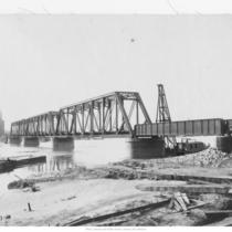
Title
-
Missouri Pacific Railroad Bridge during 1903 Flood
-
Description
-
The Missouri Pacific Railroad Bridge over the Kansas River during the 1903 flood. The people in the image are standing at the footing of the Union Pacific Railroad Bridge, which was washed away during the flood.
-
Date
-
1903
-
Object Type
-
Photograph
-
-
Title
-
Looking North - Central Street Viaduct - West Bottoms
-
Description
-
View facing north in Kansas City, Kansas. Railroad tracks, the Central Street Viaduct, the James Street Bridge, the Kansas River, and Strawberry Hill can be seen
-
Date
-
1963-10-11
-
Object Type
-
Photograph
Pages