Pages
-

-
Title
-
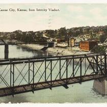
Intercity Viaduct Over Kaw River
-
Description
-
Partial view of the Intercity Viaduct over the Kaw River in Kansas City, Missouri. A railroad track and the ruins of a wooden building are visible on the river in front of the viaduct.
-
Date
-
1915-07-18
-
Object Type
-
Photograph
-

-
Title
-
Area of the Stockyards and Kaw River
-
Description
-
Area of the Stockyards and the Kaw River between 23rd St. Viaduct and Central Ave, showing buildings including Swift and Co., no date.
-
Object Type
-
Photograph
-

-
Title
-
23rd Street Bridge Construction
-
Description
-
Photograph of construction of the 23rd Street Bridge over the Kaw River in Kansas City, Missouri.
-
Date
-
1916-01-22
-
Object Type
-
Photograph
-
-
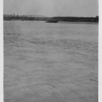
Title
-
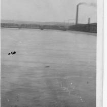
Kaw River
-
Description
-
View of the Kaw River. The handwriting on photo says, "Kaw River from L south." A bridge and chimneys are visible in background.
-
Date
-
1915-07-18
-
Object Type
-
Photograph
-

-
Title
-
Report Looks at Causes, Effects of Kansas River's Long Decline
-
Description
-
Article reviews the Kansas Water Office report that is the first comprehensive look at how the river has deteriorated over the years. ''The Kansas River, also known as the Kaw, winds 170 miles from near Manhattan through Topeka and Lawrence before it joins the Missouri.''
-
Date
-
2005-06-02
-
Object Type
-
Newspaper Article
-
-
Title
-
Chicago Great Western Railroad Bridge
-
Description
-
Partial view of the Chicago Great Western Railroad Bridge (identified on photo as C & GW Bridge) over the Kaw River in Kansas City, Kansas. Water is high.
-
Date
-
1915-07-18
-
Object Type
-
Photograph
-

-
Title
-
Kaw River, River Front
-
Description
-
Postcard of riverfront area of the Kansas River.
-
Date
-
1910
-
Object Type
-
Postcard
-
-
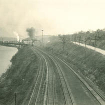
Title
-
Railroad tracks along Kaw River
-
Description
-
Santa Fe main line tracks between the Kaw River and the adjacent bluffs, looking east from the 7th Street Bridge. Photograph is part of proposed flood control projects to raise levees and railroad tracks along the Kaw River.
-
Date
-
1930~
-
Object Type
-
Photograph
-
-
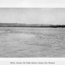
Title
-
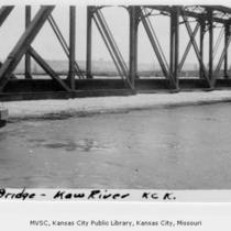
Kaw and Missouri River Junction
-
Description
-
View of the junction of the Kaw River and the Missouri River in Kansas City, Missouri, identified by handwriting on photo as Kaw Point. Buildings and a bridge are visible in background.
-
Date
-
1915-07-18
-
Object Type
-
Photograph
-
-
Title
-
Kaw and Missouri River Junction
-
Description
-
View of the junction of the Kaw River and the Missouri River in Kansas City, Missouri. Buildings and a bridge are visible in background.
-
Date
-
1915-07-18
-
Object Type
-
Photograph
-

-
Title
-
It's Just One Big Sewer
-
Description
-
Article describes the water pollution problem around the Kaw Point area of the Kansas River. A reported 2.5 billion gallons of raw sewage empties out near the Kaw Point Park each year due to Kansas City's antiquated stormwater-sewer system. The Friends of the Kaw and other organizations and agencies are lobbying for Kansas City to speed up its sewer repair schedule.
-
Date
-
2011-08-20
-
Object Type
-
Newspaper Article
-

-
Title
-
In the Bend of the Kaw
-
Description
-
Part I-Earliest Settlements, 1825-1854. The author includes quotes from standard sources. Part II-"The Farmers Came" 1855-1879 (V.1#7, p.276-279.) Part III-"Take 'er Down an 'turn 'er", 1875-1900 (V.1,#8, p.325-330) Final in series - "And the Floods Came", 1901-1951 (V.1, #9, p.380-385).
-
Date
-
2002
-
Object Type
-
Magazine Article
-

-
Title
-
Exploring the Kaw Valley
-
Description
-
Book details the Kaw River valley areas and includes a short section on the Grinter House with a photograph. Gives the history of the Grinter family and of the historical significance of the home.
-
Date
-
2002
-
Object Type
-
Book Section
-

-
Title
-
Kansas City Sheet
-
Description
-
Topographical map of the Kansas City Metropolitan area at the turn of the century, including outlying areas of Platte and Clay counties in Missouri, and Wyandotte and Johnson counties in Kansas. Township boundaries are shown as are street grids for communities including Kansas City, Harlem, Parkville, Platte City, and Weston in Missouri, and Kansas City, Leavenworth, Merriam, and Shawnee in Kansas.
-
Date
-
1894
-
Object Type
-
Map
-

-
Title
-
Wright's Map of Kansas City
-
Description
-
Detailed map of Kansas City, Missouri, that includes roads, railroads, subdivisions and additions, and some property owners. Subdivisions have been colored by an unknown source after the map was printed. A portion of Wyandotte County is also included.
-
Date
-
1884
-
Object Type
-
Map
-

-
Title
-
Map of Kansas City, Missouri
-
Description
-
Detailed street map of Kansas City, Missouri, that includes wards, railroads, and rivers. Shows businesses, cemeteries, parks, subdivisions, and some property owners.
-
Date
-
1890
-
Object Type
-
Map
-

-
Title
-
Map of the Kaw River and Vicinity from Mouth to Argentine, KS
-
Description
-
Map of the Kaw River and Vicinity from Mouth to Argentine, KS. Showing topography of channel, railroads, bridges, buildings, and adjacent streets. Compiled from original surveys made in conjunction with the investigation of floods in the Kaw River. "Plate 1" from set of 9 maps.
-
Date
-
1905
-
Object Type
-
Map
-

-
Title
-
Map of the Kaw River and Vicinity
-
Description
-
Map of the Kaw River and Vicinity. Showing topography of channel, railroads, bridges, buildings, and adjacent streets. Compiled from original surveys made in conjunction with the investigation of floods in the Kaw River. "Plate 2" from set of 9 maps.
-
Date
-
1905
-
Object Type
-
Map
Pages