-
-
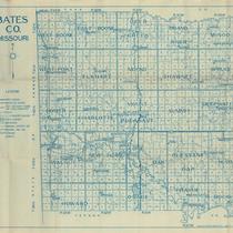
Title
-
Bates CO. Missouri
-
Description
-
Map of Bates County, Missouri, that includes paved roads, graveled roads, state or county roads not highly improved, roads, interstates and highways, railroads, drainage district line, municipal township lines, streams, and schools. Includes the townships of West Boone, East Boone, Deer Creek, Grand River, Mingo, West Point, Elkhart, Mound, Shawnee, Spruce, Homer, Charlotte, Mount Pleasant, Summit, Deepwater, Walnut, New Home, Lone Oak, Pleasant Gap, Hudson, Howard, Osage, Prairie, and Rockville.
-
Object Type
-
Map
-

-
Title
-
Pastoral Scene Belies Bloody History
-
Description
-
Postcard image of the Marais Des Cygnes River and an accompanying article about the Marias Des Cygnes Massacre that took place on May 19, 1858. The massacre involved Charles Hamilton, a pro-slavery sympathizer, and his rebel band executing five captured Free Staters near the town of Trading Post, Kansas.
-
Date
-
2011-03-30
-
Object Type
-
Newspaper Article
-

-
Title
-
A NEW Water Plant on a REHAB Budget
-
Description
-
Photos and article (written by a Kansas City engineer) about the new water plant built by Kansas City's Riddle Engineering company for the town of Butler, Missouri (in Bates County just south of Cass County), utilitzing its existing facilities and water sources consisting of the Miami Creek and the Marais des Cygnes River.
-
Date
-
1969-08
-
Object Type
-
Magazine Article
-

-
Title
-
Map of Bates County Missouri
-
Description
-
Civil War era map of Bates County, Missouri, showing roads, rivers, and towns. Typical Section numbering pattern. Map key not included.
-
Date
-
2006-08-23
-
Object Type
-
Map
