-
-
Title
-
Bates CO. Missouri
-
Description
-
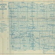
Map of Bates County, Missouri, that includes paved roads, graveled roads, state or county roads not highly improved, roads, interstates and highways, railroads, drainage district line, municipal township lines, streams, and schools. Includes the townships of West Boone, East Boone, Deer Creek, Grand River, Mingo, West Point, Elkhart, Mound, Shawnee, Spruce, Homer, Charlotte, Mount Pleasant, Summit, Deepwater, Walnut, New Home, Lone Oak, Pleasant Gap, Hudson, Howard, Osage, Prairie, and Rockville.
-
Object Type
-
Map
