-

-
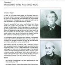
Title
-
The Fort Leavenworth-Fort Gibson Military Road and the Founding of Fort Scott
-
Description
-
Article gives the history of the establishment of the military road from Fort Snelling to Louisiana, with emphasis on the portion between Fort Leavenworth and Fort Gibson in Oklahoma. The whole route was divided into three sections: Northern - Fort Snelling to Fort Leavenworth; Southern - Arkansas River to Fort Towson; and Middle - Fort Leavenworth and the Arkansas River. Includes a map of the whole route, dated June, 1845, "compiled for the U.S. Topographical Bureau and published in Doc. 59, Serial 322; with additional data from a map [1851] accompanying Doc.1, Serial 611". Also has a map which shows the Fort Leavenworth-Fort Scott segment.
-
Date
-
1942-05-01
-
Object Type
-
Magazine Article
-

-
Title
-
The Old Military Post Road
-
Description
-
Article detailing historical and modern-day travel on the "Old Military Post Road," running from Fort Snelling, Minnesota, to Fort Jesup, Louisiana. Locations in Kansas along this road described in the article are Fort Leavenworth and the Frontier Army Museum, Grinter Place, the National Agricultural Center and Hall of Fame in Bonner Springs, Legler Barn Museum in Lenexa, the Marais des Cygnes Massacre State Historic Site, and Fort Scott.
-
Date
-
2006-05-01
-
Object Type
-
Magazine Article
-

-
Title
-
The Military Road
-
Description
-
Article details the history of the Leavenworth-Fort Scott Military Road in eastern Kansas.
-
Date
-
2001
-
Object Type
-
Magazine Article
-
-
Title
-
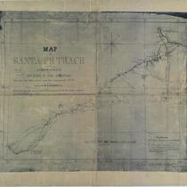
Map of Santa Fe Trace From Independence to the Crossing of the Arkansas
-
Description
-
A facsimile of the map "drawn by Capt. P. St. G. Cooke, Drags. From Notes carefully taken by him while in command of the Excursion to protect the Santa Fe Trade, 1843." Covers the trail from the Independence/Weston/Ft. Leavenworth area to the crossing 375 miles from Fort Leavenworth in western Kansas. The rivers and creeks along the trail are drawn and named. Military Road from Ft. Leavenworth to Ft. Scott is also shown. Handwritten at bottom of the map: "No. 252 - Capt. Cook's journal - recd. October 2nd 1849, R. Jones A-G."
-
Date
-
1843
-
Object Type
-
Map