-

-
Title
-
Missouri, Kansas and Texas (Katy) Railroad
-
Description
-
File contains information on the Missouri, Kansas & Texas Railroad, also called the "Katy," and associated with the Katy Trail.
-
Object Type
-
Vertical File
-

-
Title
-
Hiking and Bicycle Trails
-
Description
-
Information about the trails for hiking and biking in the Kansas City area.
-
Object Type
-
Vertical File
-
-
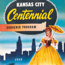
Title
-
Kansas City Centennial 1850-1950 - Souvenir Program
-
Description
-
Souvenir program book the Kansas City centennial celebration. The book details the events, organizations involved, and people associated with the celebration. The book contains many advertisements and brief articles detailing the history of various Kansas City area businesses, organizations, and public figures. An index for the book can be found on page 144.
-
Date
-
1950
-
Object Type
-
Book
-

-
Title
-
Threat to Bridge Spurs Fears
-
Description
-
Discussion about the plans of Union Pacific Railroad, current owner of the old metal railroad bridge at Boonville, to tear down the bridge. Katy Trail enthusaists hope the bridge can be used as a river crossing.
-
Date
-
2005-07-03
-
Object Type
-
Newspaper Article
-
-
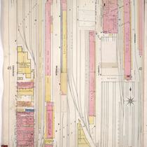
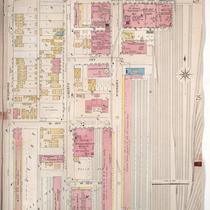
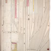
Title
-
Sanborn Map, Kansas City, Vol. 1, 1909-1938, Page p047
-
Description
-
A portion of Kansas City from W. 14th Street south to W. 16th Street and from Genessee east to Hickory, showing buildings, streets, railroads, and additions. Large numbers at edges of page refer to page with adjoining area.
-
Date
-
1909/1938
-
Object Type
-
Map
-
-
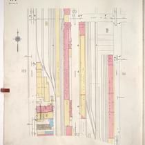
Title
-
Sanborn Map, Kansas City, Vol. 1A, 1939-1949, Page p171
-
Description
-
A portion of Kansas City from W. 14th Street south to about W. 15th Street and from Genessee east to Liberty, showing buildings, railroads and streets. Large numbers at edges of page refer to page with adjoining area.
-
Date
-
1939/1949
-
Object Type
-
Map
-
-
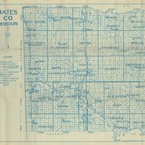
Title
-
Bates CO. Missouri
-
Description
-
Map of Bates County, Missouri, that includes paved roads, graveled roads, state or county roads not highly improved, roads, interstates and highways, railroads, drainage district line, municipal township lines, streams, and schools. Includes the townships of West Boone, East Boone, Deer Creek, Grand River, Mingo, West Point, Elkhart, Mound, Shawnee, Spruce, Homer, Charlotte, Mount Pleasant, Summit, Deepwater, Walnut, New Home, Lone Oak, Pleasant Gap, Hudson, Howard, Osage, Prairie, and Rockville.
-
Object Type
-
Map
-
-
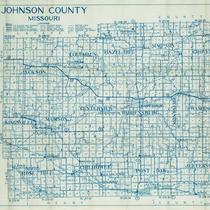
Title
-
Johnson County, Missouri
-
Description
-
Map of Johnson County, Missouri, that includes highways, county roads, township roads, political township lines, railroads, drainage ditches, streams, and schools. Included are townships Jackson, Columbus, Hazel Hill, Simpson, Grover, Kingsville, Madison, Centerview, Warrensburg, Washington, Montserrat, Rose Hill, Chilhowee, Post Oak, and Jefferson.
-
Object Type
-
Map
-
-
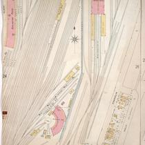
Title
-
Sanborn Map, Kansas City, Vol. 1, 1895-1907, Page p024
-
Description
-
Northwestern part of early Kansas City in West Bottoms from Wyoming Street east to Hickory Street and from W. 13th Street south to W. 15th Street. Large numbers at edges of page refer to page with adjoining area.
-
Date
-
1895/1907
-
Object Type
-
Map
-
-
Title
-
Sanborn Map, Kansas City, Vol. 1, 1895-1907, Page p025
-
Description
-
Northern part of early Kansas City in West Bottoms from Mulberry Street east to Holly Street showing railroad lines and buildings. Large numbers at edge of page refer to page with adjoining area.
-
Date
-
1895/1907
-
Object Type
-
Map
-
-
Title
-
Sanborn Map, Kansas City, Vol. 1A, 1939-1957, Page p171
-
Description
-
A portion of Kansas City from W. 14th Street south to about W. 15th Street and from Genessee east to Liberty, showing buildings, railroads, and streets. Large numbers at edges of page refer to page with adjoining area.
-
Date
-
1939/1957
-
Object Type
-
Map
-
-
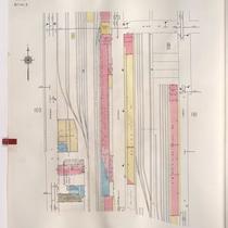
Title
-
Sanborn Map, Kansas City, Vol. 1, 1895-1907, Page p036
-
Description
-
Northwestern part of early Kansas City in the West Bottoms from about W. 15th Street south to W. 17th Street and from Wyoming Street east to Atchison, Topeka and Santa Fe rail lines. Large numbers at edges of page refer to page with adjoining area.
-
Date
-
1895/1907
-
Object Type
-
Map
-
-
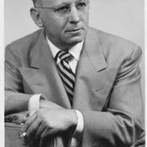
Title
-
V. V. Masterson
-
Description
-
Portrait of Vincent V. Masterson, author of The Katy Railroad and the Last Frontier (MVSC 385.2 M67m). Masterson spoke to the South Central Business Association on the subject of railroad history, November 18, 1952.
-
Date
-
1952~
-
Object Type
-
Photograph
-

-
Title
-
Fighting the River on the Katy Trail, 1892-1992
-
Description
-
History of the Katy Trail on its centennial anniversary, named after "the Missouri, Kansas & Texas ('Katy') Railway," named "officially the Missouri River State Trail." Description of the determination and construction of the railroad's route from Texas to Saint Louis and Kansas City, with maps and photos.
-
Date
-
1991
-
Object Type
-
Magazine Article
-

-
Title
-
Bridge Over Troubled Water
-
Description
-
Article reviews the political struggle over the fate of the Katy Bridge at Boonville. The bridge for the MKT (Missouri-Kansas-Texas) railroad was built in 1932 and at the time was the largest lift-span bridge in the United States. It was also "a second incarnation of a bridge that was constructed in 1874." The Katy Trail takes a detour at Boonville to bypass the rail bridge. Union Pacific, owners of the bridge, plan to recycle bridge materials for use in a different location, saying this could save them close to eight million dollars. Save the Katy Bridge Coalition is working hard to raise funds to refurbish it for pedestrian and bicycle use on the Katy Trail.
-
Date
-
2008-08
-
Object Type
-
Magazine Article
-

-
Title
-
A Race for Sixty Millions
-
Description
-
Article about the race among railroads toward "three million acres of Oklahoma's most fertile territory," worth 60 million dollars for the Missouri, Kansas & Texas Railroad, "the expectant recipient" from 1866 to 1870, with photos of people concerned and a map of the area concerned in southeastern Kansas between Kansas City, Fort Riley, and Coffeyville. Description also of the influence of the competition encouraged by Congress, the towns built up along the railway routes, and the United States Supreme Court case over the profits.
-
Date
-
1914-06
-
Object Type
-
Magazine Article
-

-
Title
-
Map of Randolph CO. MO.
-
Description
-
Map of Randolph County, Missouri, that includes roads, steam railroads, streams, schools, churches, and cemeteries. Includes the townships of Chariton, Jackson, Salt River, Clifton, Salt Spring, Cairo, Union, Sugar Creek, Silver Creek, Moniteau, and Prairie.
-
Date
-
1910
-
Object Type
-
Map
-
-
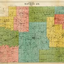
Title
-
Map of Monroe CO. MO.
-
Description
-
Map of Monroe County, Missouri, that includes schools, churches, cemeteries, roads, railroads, and streams. Includes the townships of Woodlawn, Clay, Washington, Monroe, Marion, Union, Jackson, Indian Creek, Jefferson, and South Fork.
-
Date
-
1910
-
Object Type
-
Map
