Pages
-

-
Title
-
Kansas City Centennial 1850-1950 - Souvenir Program
-
Description
-
Souvenir program book the Kansas City centennial celebration. The book details the events, organizations involved, and people associated with the celebration. The book contains many advertisements and brief articles detailing the history of various Kansas City area businesses, organizations, and public figures. An index for the book can be found on page 144.
-
Date
-
1950
-
Object Type
-
Book
-

-
Title
-
Quit Claim Deed: Missouri Pacific Railroad Company
-
Description
-
Photocopy of a quit claim deed notarized on July 2, 1971. The document lists the Missouri Pacific Railroad Company as the grantor and Lighting Industries, Incorporated as the grantee. The document references property at 801 Woodswether Road in the West Bottoms area of Kansas City, Missouri.
-
Date
-
1971-07-02
-
Object Type
-
Vertical File
-

-
Title
-
6th Annual Goodfellowship Tour to Eureka Springs, Ark.
-
Description
-
Group portrait of participants of the South Central Business Association's 6th annual Good Fellowship Tour to Eureka Springs, Arkansas. Crescent Lake and Lake Lucerne are noted on the photograph. The group is posed in front of a Missouri Pacific Railway train in Harrisonville, Missouri.
-
Date
-
1935
-
Object Type
-
Photograph
-

-
Title
-
Railway Bridge
-
Description
-
Distant view from eastern shore of the Kansas River of entire bridge.
-
Object Type
-
Photograph
-

-
Title
-
Missouri Pacific Railroad Bridge during 1903 Flood
-
Description
-
The Missouri Pacific Railroad Bridge over the Kansas River during the 1903 flood. The people in the image are standing at the footing of the Union Pacific Railroad Bridge, which was washed away during the flood.
-
Date
-
1903
-
Object Type
-
Photograph
-

-
Title
-
Missouri Pacific Railroad Cars
-
Description
-
Partial frontal view of company employment agency; unidentified man asleep on sidewalk in foreground.
-
Object Type
-
Photograph
-

-
Title
-
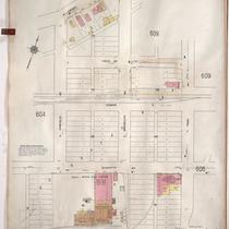
Sanborn Map, Kansas City, Vol. 5, 1909-1938, Page p603
-
Description
-
A portion of Kansas City from E. Front Street south to E. 1st Street and from N. Vine Street east to Woodland Avenue, showing buildings, streets, railroads, and additions. Large numbers at edges of page refer to page with adjoining area.
-
Date
-
1909/1938
-
Object Type
-
Map
-
-
Title
-
Sanborn Map, Kansas City, Vol. 5, 1909-1938, Page p605
-
Description
-
A portion of Kansas City from E. Front Street south to Guinotte Avenue and from N. Garfield Avenue east to N. Park Avenue, showing buildings, streets, and additions. Large numbers at edges of page refer to page with adjoining area.
-
Date
-
1909/1938
-
Object Type
-
Map
-

-
Title
-
Sanborn Map, Kansas City, Vol. 5, 1909-1938, Page p724
-
Description
-
A portion of Kansas City in the Leed's Industrial District, showing buildings, streets, and railroads. Large numbers at edges of page refer to page with adjoining area. At the top of page, "Add'l Sheet, Nov. 1928."
-
Date
-
1909/1938
-
Object Type
-
Map
-

-
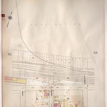
Title
-
Sanborn Map, Kansas City, Vol. 2, 1909-1937, Page p154
-
Description
-
A portion of Kansas City from Front Street south to E. 2nd Street and from Charlotte east to Harrison, showing buildings, streets, railroads, and additions. Large numbers at edges of page refer to page with adjoining area.
-
Date
-
1909/1937
-
Object Type
-
Map
-
-
Title
-
Sanborn Map, Kansas City, Vol. 2, 1909-1937, Page p153
-
Description
-
A portion of Kansas City Old Town from E. 1st Street south to E. 2nd Street and from Cherry Street east to Charlotte, showing buildings, streets, railroads, and additions. Large numbers at edges of page refer to page with adjoining area.
-
Date
-
1909/1937
-
Object Type
-
Map
-
-
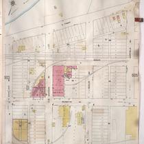
Title
-
Sanborn Map, Kansas City, Vol. 5, 1909-1938, Page p604
-
Description
-
A portion of Kansas City from E. Front Street south to E. 1st Street and from N. Woodland Avenue east to Garfield Avenue, showing buildings, streets, railroads, and additions. Shows The Kansas City Star printing paper storage house. Large numbers at edges of page refer to page with adjoining area.
-
Date
-
1909/1938
-
Object Type
-
Map
-

-
Title
-
Sanborn Map, Kansas City, Vol. 5, 1909-1938, Page p689
-
Description
-
A portion of Kansas City at the intersection of Cambridge Avenue and Winner Road, showing buildings, streets, railroads, and additions. Large numbers at edges of page refer to page with adjoining area. At the top of page, "New Sheet May 1922."
-
Date
-
1909/1938
-
Object Type
-
Map
-

-
Title
-
Sanborn Map, Kansas City, Vol. 5, 1909-1938, Page p706
-
Description
-
A portion of Kansas City from E. 38th Street south to E. 40th Street and from Fremont Avenue east to Bennington Avenue, showing buildings, streets, railroads, and additions. Large numbers at edges of page refer to page with adjoining area.
-
Date
-
1909/1938
-
Object Type
-
Map
-

-
Title
-
Sanborn Map, Kansas City, Vol. 5, 1909-1938, Page p690
-
Description
-
A portion of Kansas City in the Sheffield neighborhood near Crystal Avenue and the Blue River, showing buildings, streets, railroads, and additions. Large numbers at edges of page refer to page with adjoining area.
-
Date
-
1909/1938
-
Object Type
-
Map
Pages


