-

-
Title
-
Sanborn Map, Kansas City, Vol. 6, 1917-1957, Page p846
-
Description
-
A portion of Cement City near the Missouri River located 10 miles northeast of Kansas City's Union Depot, showing buildings, streets, and railroad lines. Large numbers at edges of page refer to page with adjoining area.
-
Date
-
1917/1957
-
Object Type
-
Map
-

-
Title
-
Sanborn Map, Kansas City, Vol. 6, 1917-1957, Page p833
-
Description
-
Index to New Report of Intercity District showing area connecting Kansas City, Missouri, and Independence, Missouri, as well as Sugar Creek district, dated December 1932. At bottom of sheet is a portion of Sugar Creek from Scarritt Avenue south to Kentucky Avenue and from Home Avenue east to Ralston Avenue, showing buildings, streets, and additions. Large numbers at edges of page refer to page with adjoining area. A new report for Sugar Creek is also attached dated November 1939.
-
Date
-
1917/1957
-
Object Type
-
Map
-
-
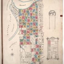
Title
-
Sanborn Map, Kansas City, Vol. 1, 1895-1907, Page f008
-
Description
-
Key to Sanborn Map of Kansas City, Vol. 1 (corrected to January 1907), showing Kansas City area bounded from the Kansas and Missouri State Line on the west, Cherry on the east, the Missouri River to the north, and East 43rd to the south. Also shows railroads, bridges, parks, and a cemetery. Indicates area covered by volumes 2 and 3.
-
Date
-
1895/1907
-
Object Type
-
Map
-

-
Title
-
Sanborn Map, Kansas City, Vol. 6, 1917-1945, Page p846
-
Description
-
A portion of Cement City near the Missouri River located 10 miles northeast of Kansas City's Union Depot, showing buildings, streets, and railroad lines. Large numbers at edges of page refer to page with adjoining area.
-
Date
-
1917/1945
-
Object Type
-
Map
-

-
Title
-
Map of Jackson County, Missouri
-
Description
-
Map of Jackson County, Missouri, depicting roads (graded, rock, county), railroads, streams, schools, and churches. Includes townships of Blue, Brooking, Washington, Prairie, Van Buren, Sni-a-bar, and Fort Osage, and cities of Kansas City and Independence. Also includes major farms: Walton-Holmes, Minor, F. G. Robinson, Belvedere, W. D. Johnson, Longview, Malvern Land Co., Blackwell, Barzen, J. C. Knopp, Alexander, King, La Cima, Fields, Yost, Velie, Sni-a-bar, Andrew Drumm, Swinney, and McCoy.
-
Date
-
1917
-
Object Type
-
Map
