-

-
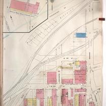
Title
-
Sanborn Map, Kansas City, Vol. 1A, 1939-1949, Page p189
-
Description
-
A portion of Kansas City from Woodswether Road south to W. 7th Street and from Madison Avenue east to Broadway, showing buildings, railroads and streets. Large numbers at edges of page refer to page with adjoining area
-
Date
-
1939/1949
-
Object Type
-
Map
-

-
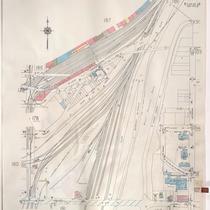
Title
-
Sanborn Map, Kansas City, Vol. 1A, 1939-1949, Page p188
-
Description
-
A portion of Kansas City from W. 9th Street south to W. 12th Street and from Santa Fe east to Jefferson, showing buildings, railroads and streets. Large numbers at edges of page refer to page with adjoining area.
-
Date
-
1939/1949
-
Object Type
-
Map
-

-
Title
-
Sanborn Map, Kansas City, Vol. 1, 1909-1938, Page p001
-
Description
-
A portion of Kansas City from W. 5th Street south to W. 7th Street and from Woodswether Road east to Pennsylvania Avenue, showing buildings, streets, and railroads. Large numbers at edges of page refer to page with adjoining area.
-
Date
-
1909/1938
-
Object Type
-
Map
-
-
Title
-
Sanborn Map, Kansas City, Vol. 1, 1909-1938, Page p002
-
Description
-
A portion of Kansas City from W. 3rd Street south to W. 5th Street and from Bluff Street east to Broadway, showing buildings, streets, railroads, and additions. Large numbers at edges of page refer to page with adjoining area.
-
Date
-
1909/1938
-
Object Type
-
Map
-

-
Title
-
Sanborn Map, Kansas City, Vol. 1, 1939-1958, Page p043
-
Description
-
A portion of Kansas City from W. 1st Street south to W. 3rd Street and from Broadway east to Wyandotte, showing buildings and streets. Large numbers at edges of page refer to page with adjoining area.
-
Date
-
1939/1958
-
Object Type
-
Map
-

-
Title
-
Sanborn Map, Kansas City, Vol. 1, 1909-1938, Page p003
-
Description
-
A portion of Kansas City from W. Front south to W. 3rd Street and from Broadway east to Wyandotte, showing buildings, streets, railroads, and additions. Large numbers at edges of page refer to page with adjoining area.
-
Date
-
1909/1938
-
Object Type
-
Map
-

-
Title
-
Sanborn Map, Kansas City, Vol. 1A, 1939-1957, Page p189
-
Description
-
A portion of Kansas City from Woodswether Road south to W. 7th Street and from Madison Avenue east to Broadway, showing buildings, railroads, and streets. Large numbers at edges of page refer to page with adjoining area.
-
Date
-
1939/1957
-
Object Type
-
Map
-
-
Title
-
Sanborn Map, Kansas City, Vol. 1A, 1939-1957, Page p188
-
Description
-
A portion of Kansas City from W. 9th Street south to W. 12th Street and from Santa Fe east to Jefferson, showing buildings, railroads, and streets. Large numbers at edges of page refer to page with adjoining area.
-
Date
-
1939/1957
-
Object Type
-
Map
