-

-
Title
-
Sanborn Map, Kansas City, Vol. 6, 1917-1957, Page p857
-
Description
-
A portion of Sugar Creek, Missouri, from Ohio Street south to just past Independence Avenue and from S. Hardy Avenue east to Carlisle Street, showing buildings, streets, and additions. Large numbers at edges of page refer to page with adjoining area. Noted at top of map, "(708-Vol. 5) Add'l Sheet, Nov. 1939."
-
Date
-
1917/1957
-
Object Type
-
Map
-

-
Title
-
Sanborn Map, Kansas City, Vol. 6, 1917-1957, Page p833
-
Description
-
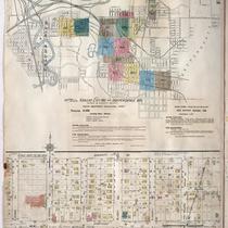
Index to New Report of Intercity District showing area connecting Kansas City, Missouri, and Independence, Missouri, as well as Sugar Creek district, dated December 1932. At bottom of sheet is a portion of Sugar Creek from Scarritt Avenue south to Kentucky Avenue and from Home Avenue east to Ralston Avenue, showing buildings, streets, and additions. Large numbers at edges of page refer to page with adjoining area. A new report for Sugar Creek is also attached dated November 1939.
-
Date
-
1917/1957
-
Object Type
-
Map
-

-
Title
-
Sanborn Map, Kansas City, Vol. 5, 1909-1938, Page p708
-
Description
-
A portion of Kansas City at the intersection of Independence Avenue and Northern Boulevard, showing buildings, streets, railroads, and additions. Large numbers at edges of page refer to page with adjoining area. At the top of page, "Located on S. half of Sec. 33, 7 1/2 miles E. of P. O."
-
Date
-
1909/1938
-
Object Type
-
Map
-

-
Title
-
Sanborn Map, Kansas City, Vol. 6, 1917-1945, Page p857
-
Description
-
A portion of Sugar Creek, Missouri, from Ohio Street south to just past Independence Avenue and from S. Hardy Avenue east to Carlisle Street, showing buildings, streets, and additions. Large numbers at edges of page refer to page with adjoining area. At top of map, "(708-Vol. 5) Add'l Sheet, Nov. 1939."
-
Date
-
1939
-
Object Type
-
Map
-
-
Title
-
Sanborn Map, Kansas City, Vol. 6, 1917-1945, Page p833
-
Description
-
Index to New Report of Intercity District showing area connecting Kansas City, Missouri and Independence, Missouri, as well as Sugar Creek district, dated December 1932. At bottom of sheet is a portion of Sugar Creek from Scarritt Avenue south to Kentucky Avenue and from Home Avenue east to Ralston Avenue, showing buildings, streets and additions. Large numbers at edges of page refer to page with adjoining area.
-
Date
-
1917/1945
-
Object Type
-
Map
