-

-
Title
-
Sanborn Map, Kansas City, Vol. 1, 1895-1907, Page p011
-
Description
-
Northern edge of early Kansas City. Quality Hill area showing buildings, railroad lines, and streets. Large numbers at edges of page refer to page showing adjoining area.
-
Date
-
1895/1907
-
Object Type
-
Map
-

-
Title
-
Sanborn Map, Kansas City, Vol. 1, 1895-1907, Page p003
-
Description
-
Northern edge of early Kansas City. Riverfront area shows buildings, railroad lines, and streets. Large numbers at edge of page refer to page number or volume with adjoining area.
-
Date
-
1895/1907
-
Object Type
-
Map
-

-
Title
-
Sanborn Map, Kansas City, Vol. 1, 1895-1907, Page p001
-
Description
-
North western edge of early Kansas City, riverfront area showing railroads, bridges, buildings and streets and the Missouri River. Large numbers at edges of page lead to page showing adjoining area.
-
Date
-
1895/1907
-
Object Type
-
Map
-

-
Title
-
Sanborn Map, Kansas City, Vol. 3, 1896-1907, Page p356
-
Description
-
Northern part of early Kansas City in Randolph, Missouri, showing railroad lines, buildings, and streets. Large numbers at edges of page refer to page with adjoining area. At top of map, "Randolph, Clay Co., Mo., situated 7 miles n.e. of post office."
-
Date
-
1896/1907
-
Object Type
-
Map
-
-
Title
-
Sanborn Map, Kansas City, Vol. 1, 1895-1907, Page f008
-
Description
-
Key to Sanborn Map of Kansas City, Vol. 1 (corrected to January 1907), showing Kansas City area bounded from the Kansas and Missouri State Line on the west, Cherry on the east, the Missouri River to the north, and East 43rd to the south. Also shows railroads, bridges, parks, and a cemetery. Indicates area covered by volumes 2 and 3.
-
Date
-
1895/1907
-
Object Type
-
Map
-

-
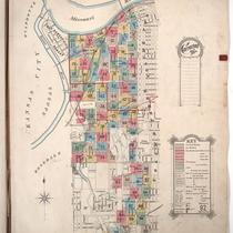
Title
-
City of Kansas
-
Description
-
Photocopy of a cadastral map showing landowners and building outlines for the area of the City of Kansas west and north of Union Depot, comprising West Kansas Addition, Pacific Place, and Turner & Company's Addition. Companies named include S. B. Armour, Hannibal & St. Joseph Railroad, Missouri Pacific Railroad, and Morrison Packing. Key ("Explanations") at bottom of map.
-
Date
-
1886
-
Object Type
-
Map
