Pages
-

-
Title
-
Sanborn Map, Kansas City, Vol. 5, 1909-1938, Page p724
-
Description
-
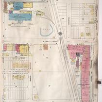
A portion of Kansas City in the Leed's Industrial District, showing buildings, streets, and railroads. Large numbers at edges of page refer to page with adjoining area. At the top of page, "Add'l Sheet, Nov. 1928."
-
Date
-
1909/1938
-
Object Type
-
Map
-

-
Title
-
Sanborn Map, Kansas City, Vol. 5, 1909-1938, Page p706
-
Description
-
A portion of Kansas City from E. 38th Street south to E. 40th Street and from Fremont Avenue east to Bennington Avenue, showing buildings, streets, railroads, and additions. Large numbers at edges of page refer to page with adjoining area.
-
Date
-
1909/1938
-
Object Type
-
Map
-

-
Title
-
Sanborn Map, Kansas City, Vol. 5, 1909-1938, Page p692
-
Description
-
A portion of Kansas City from Washington Park Boulevard south to E. 7th Street and from Cambridge Avenue east to Winchester Avenue, showing buildings, streets, and additions. Large numbers at edges of page refer to page with adjoining area.
-
Date
-
1909/1938
-
Object Type
-
Map
-

-
Title
-
Sanborn Map, Kansas City, Vol. 6, 1917-1957, Page p857
-
Description
-
A portion of Sugar Creek, Missouri, from Ohio Street south to just past Independence Avenue and from S. Hardy Avenue east to Carlisle Street, showing buildings, streets, and additions. Large numbers at edges of page refer to page with adjoining area. Noted at top of map, "(708-Vol. 5) Add'l Sheet, Nov. 1939."
-
Date
-
1917/1957
-
Object Type
-
Map
-

-
Title
-
Sanborn Map, Kansas City, Vol. 6, 1917-1957, Page p860
-
Description
-
A portion of Leeds, Missouri, from E. 37th Street south to E. 40th Street and from Bennington Avenue east to Raytown Road, showing buildings, streets, and additions. Large numbers at edges of page refer to page with adjoining area. Noted at top of map, "(705-706-707-724-Vol. 5) Add'l Sheet, Nov. 1939."
-
Date
-
1917/1957
-
Object Type
-
Map
-

-
Title
-
Sanborn Map, Kansas City, Vol. 6, 1917-1957, Page p859
-
Description
-
A portion of Leeds, Missouri, from E. 37th Street south to E. 40th Street and from Belmont Avenue east to Bennington Avenue, showing buildings, streets, and additions. Large numbers at edges of page refer to page with adjoining area. Noted at top of map, "(705-706-722-Vol. 5) Add'l Sheet, Nov. 1939."
-
Date
-
1917/1957
-
Object Type
-
Map
-

-
Title
-
Sanborn Map, Kansas City, Vol. 5, 1909-1938, Page p707
-
Description
-
A portion of Kansas City at the intersection of E. 39th Street and Ewing Avenue, showing buildings, streets, railroads, and additions. Large numbers at edges of page refer to page with adjoining area.
-
Date
-
1909/1938
-
Object Type
-
Map
-

-
Title
-
Sanborn Map, Kansas City, Vol. 5, 1909-1938, Page p699
-
Description
-
A portion of Kansas City from E. 16th Street south to E. 17th Street and from Ewing Avenue east to Bristol Avenue, showing buildings, streets, railroads, and additions. Large numbers at edges of page refer to page with adjoining area.
-
Date
-
1909/1938
-
Object Type
-
Map
-
-
Title
-
Sanborn Map, Kansas City, Vol. 6, 1917-1957, Page p833
-
Description
-
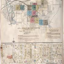
Index to New Report of Intercity District showing area connecting Kansas City, Missouri, and Independence, Missouri, as well as Sugar Creek district, dated December 1932. At bottom of sheet is a portion of Sugar Creek from Scarritt Avenue south to Kentucky Avenue and from Home Avenue east to Ralston Avenue, showing buildings, streets, and additions. Large numbers at edges of page refer to page with adjoining area. A new report for Sugar Creek is also attached dated November 1939.
-
Date
-
1917/1957
-
Object Type
-
Map
-

-
Title
-
Sanborn Map, Kansas City, Vol. 5, 1940-1941, Page p1216
-
Description
-
A portion of Kansas City from the Big Blue River south to E. 24th Street and from the Saint Louis and San Francisco Railroad east to Tullis Avenue, showing buildings and streets. Large numbers at edges of page refer to page with adjoining area. Indicated at top of sheet that this page number corresponds with pages 707, 710 and 722 in Vol. 5, 1909-1938.
-
Date
-
1940/1941
-
Object Type
-
Map
-

-
Title
-
Sanborn Map, Kansas City, Vol. 1A, 1939-1949, Page p188
-
Description
-
A portion of Kansas City from W. 9th Street south to W. 12th Street and from Santa Fe east to Jefferson, showing buildings, railroads and streets. Large numbers at edges of page refer to page with adjoining area.
-
Date
-
1939/1949
-
Object Type
-
Map
-

-
Title
-
Sanborn Map, Kansas City, Vol. 5, 1940-1941, Page p0645
-
Description
-
A portion of Kansas City just north of the intersection of Bristol Avenue and E. 6th Street, showing buildings, railroads and streets. Large numbers at edges of page refer to page with adjoining area. Indicated at top of sheet that this page number corresponds with pages 689, 690, and 692 in Vol. 5, 1909-1938.
-
Date
-
1940/1941
-
Object Type
-
Map
-

-
Title
-
Sanborn Map, Kansas City, Vol. 5, 1940-1941, Page p1214
-
Description
-
A portion of Kansas City from E. 15th Street south to E. 18th Street and from Crystal Avenue east to Winchester Avenue, showing buildings and streets. Large numbers at edges of page refer to page with adjoining area. Indicated at top of sheet that this page number corresponds with pages 698 and 700-702 in Vol. 5, 1909-1938.
-
Date
-
1940/1941
-
Object Type
-
Map
-

-
Title
-
Sanborn Map, Kansas City, Vol. 5, 1940-1941, Page p0644
-
Description
-
A portion of Kansas City from St. John Avenue south to Wilson Avenue and from Bennington Avenue east to Cambridge Avenue, showing buildings, railroads, and streets. Large numbers at edges of page refer to page with adjoining area. Indicated at top of sheet that this page number corresponds with pages 603, 613, 687, 689, 695 and 711 in Vol. 5, 1909-1938.
-
Date
-
1940/1941
-
Object Type
-
Map
-

-
Title
-
Sanborn Map, Kansas City, Vol. 5, 1909-1938, Page p702
-
Description
-
A portion of Kansas City from E. 16th Street south to E. 17th Street and from Eastern Avenue east to Palmer Avenue, showing buildings, streets, railroads, and additions. Large numbers at edges of page refer to page with adjoining area.
-
Date
-
1909/1938
-
Object Type
-
Map
-

-
Title
-
Sanborn Map, Kansas City, Vol. 5, 1909-1938, Page p708
-
Description
-
A portion of Kansas City at the intersection of Independence Avenue and Northern Boulevard, showing buildings, streets, railroads, and additions. Large numbers at edges of page refer to page with adjoining area. At the top of page, "Located on S. half of Sec. 33, 7 1/2 miles E. of P. O."
-
Date
-
1909/1938
-
Object Type
-
Map
-

-
Title
-
Sanborn Map, Kansas City, Vol. 5, 1940-1941, Page p0614
-
Description
-
A portion of Kansas City from E. 6th Street south to E. 12th Street and from Winchester Avenue east to Eastern Avenue, showing buildings, railroads, and streets. Large numbers at edges of page refer to page with adjoining area. Indicated at top of sheet that this page number corresponds with pages 696, 699, 703, and 709 in Vol. 5, 1909-1938.
-
Date
-
1940/1941
-
Object Type
-
Map
-

-
Title
-
Sanborn Map, Kansas City, Vol. 5, 1909-1938, Page p698
-
Description
-
A portion of Kansas City from E. 13th Street south to E. 16th Street and from Bristol Avenue east to Eastern Avenue, showing buildings, streets, railroads, and additions. Large numbers at edges of page refer to page with adjoining area.
-
Date
-
1909/1938
-
Object Type
-
Map
-

-
Title
-
Sanborn Map, Kansas City, Vol. 5, 1909-1938, Page p700
-
Description
-
A portion of Kansas City from E. 16th Street south to E. 17th Street and from Bristol Avenue east to Eastern Avenue, showing buildings, streets, railroads, and additions. Large numbers at edges of page refer to page with adjoining area.
-
Date
-
1909/1938
-
Object Type
-
Map
-
-
Title
-
Sanborn Map, Kansas City, Vol. 5, 1909-1938, Page p696
-
Description
-
A portion of Kansas City from E. 11th Street south to E. 13th Street and from Winchester Avenue east to Crystal Avenue, showing buildings, streets, and additions. Large numbers at edges of page refer to page with adjoining area.
-
Date
-
1909/1938
-
Object Type
-
Map
Pages
