Pages
-

-
Title
-
Sanborn Map, Kansas City, Vol. 3, 1896-1907, Page p350
-
Description
-
Northeastern part of early Kansas City near Independence, Missouri, in the industrial areas along the rail lines, showing buildings, streets, and railroad lines. Large numbers at edges of page refer to page with adjoining area.
-
Date
-
1896/1907
-
Object Type
-
Map
-

-
Title
-
Sanborn Map, Kansas City, Vol. 2, 1896-1907, Page p219
-
Description
-
Northeastern part of early Kansas City from about Guinotte Avenue south to about Saint John Avenue and from Lexington Avenue east to Highland Avenue, showing buildings, streets, and railroad lines. Large numbers at edges of page refer to page with adjoining area.
-
Date
-
1896/1907
-
Object Type
-
Map
-

-
Title
-
Sanborn Map, Kansas City, Vol. 1A, 1939-1957, Page p177
-
Description
-
A portion of Kansas City from W. 9th Street south to Union Avenue and from Liberty east to Mulberry, showing buildings, railroads, and streets. Large numbers at edges of page refer to page with adjoining area.
-
Date
-
1939/1957
-
Object Type
-
Map
-

-
Title
-
Sanborn Map, Kansas City, Vol. 1, 1895-1907, Page p011
-
Description
-
Northern edge of early Kansas City. Quality Hill area showing buildings, railroad lines, and streets. Large numbers at edges of page refer to page showing adjoining area.
-
Date
-
1895/1907
-
Object Type
-
Map
-

-
Title
-
Sanborn Map, Kansas City, Vol. 1, 1895-1907, Page p002
-
Description
-
Northern boundary (Missouri River) of Kansas City Old Town showing streets, buildings, railroad lines, and bridges. Large numbers at edge of page refer to page number with adjoining area.
-
Date
-
1895/1907
-
Object Type
-
Map
-

-
Title
-
Sanborn Map, Kansas City, Vol. 1, 1895-1907, Page p003
-
Description
-
Northern edge of early Kansas City. Riverfront area shows buildings, railroad lines, and streets. Large numbers at edge of page refer to page number or volume with adjoining area.
-
Date
-
1895/1907
-
Object Type
-
Map
-

-
Title
-
Sanborn Map, Kansas City, Vol. 1, 1895-1907, Page p013
-
Description
-
Northern part of early Kansas City in the West Bottoms from W. 8th Street south to Union Avenue and from Santa Fe Street east to Lincoln Street. Large numbers on the edges of page refer to page with adjoining area.
-
Date
-
1895/1907
-
Object Type
-
Map
-

-
Title
-
Sanborn Map, Kansas City, Vol. 1, 1895-1907, Page p017
-
Description
-
Northwestern edge of early Kansas City in the West Bottoms district from just north of St. Louis Avenue south to W. 12th Street and from the state line east to Wyoming Street, showing buildings, streets, and railroad lines. Large numbers on edges of page refer to page showing adjoining area.
-
Date
-
1895/1907
-
Object Type
-
Map
-

-
Title
-
Sanborn Map, Kansas City, Vol. 1, 1895-1907, Page p018
-
Description
-
Northwestern part of early Kansas City from Missouri River south to St. Louis Avenue and from Santa Fe Street east to Bluff Street, showing buildings, streets, and railroad lines. Large numbers on edges of page refer to page with adjoining area.
-
Date
-
1895/1907
-
Object Type
-
Map
-

-
Title
-
Sanborn Map, Kansas City, Vol. 1, 1895-1907, Page p001
-
Description
-
North western edge of early Kansas City, riverfront area showing railroads, bridges, buildings and streets and the Missouri River. Large numbers at edges of page lead to page showing adjoining area.
-
Date
-
1895/1907
-
Object Type
-
Map
-

-
Title
-
Sanborn Map, Kansas City, Vol. 2, 1896-1907, Page p126
-
Description
-
Northeastern part of early Kansas City from E. Front Street south to about E. 1st Street and from Troost Avenue east to Lexington Avenue, showing buildings, streets, and railroad lines. Large numbers at edges of page refer to page with adjoining area.
-
Date
-
1896/1907
-
Object Type
-
Map
-

-
Title
-
Sanborn Map, Kansas City, Vol. 3, 1896-1907, Page p349
-
Description
-
Northeastern part of early Kansas City in the industrial areas along the rail lines, showing buildings, streets, and the railroad lines. Large numbers at edges of page refer to page with adjoining area.
-
Date
-
1896/1907
-
Object Type
-
Map
-
-
Title
-
Sanborn Map, Kansas City, Vol. 3, 1896-1907, Page p347
-
Description
-
Northeastern part of early Kansas City from E. 13th Street south to E. 15th Street and from Corington Avenue east to Oakland Avenue, showing buildings, streets, railroads, and additions. Large numbers at edges of page refer to page with adjoining area.
-
Date
-
1896/1907
-
Object Type
-
Map
-

-
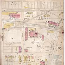
Title
-
Sanborn Map, Kansas City, Vol. 2, 1896-1907, Page p216
-
Description
-
Northeastern part of early Kansas City from about Nicholson Avenue south to Rochester Avenue and from Montgall Avenue east to East Lynne Avenue, showing buildings, streets, and the area that was formerly Electric Park. Large numbers at edges of page refer to page with adjoining area.
-
Date
-
1896/1907
-
Object Type
-
Map
-

-
Title
-
Sanborn Map, Kansas City, Vol. 3, 1896-1907, Page p356
-
Description
-
Northern part of early Kansas City in Randolph, Missouri, showing railroad lines, buildings, and streets. Large numbers at edges of page refer to page with adjoining area. At top of map, "Randolph, Clay Co., Mo., situated 7 miles n.e. of post office."
-
Date
-
1896/1907
-
Object Type
-
Map
-

-
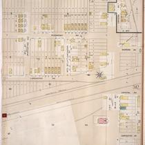
Title
-
Sanborn Map, Kansas City, Vol. 2, 1896-1907, Page p214
-
Description
-
Northeastern part of early Kansas City from Rochester Avenue south to Guinotte Avenue and from Propect Avenue east to Chestnut Avenue, showing buildings, streets, and railroad lines. Large numbers at edges of page refer to page with adjoining area.
-
Date
-
1896/1907
-
Object Type
-
Map
-

-
Title
-
Sanborn Map, Kansas City, Vol. 3, 1896-1907, Page p351
-
Description
-
Northeastern part of early Kansas City near Independence, Missouri, along the rail lines, showing buildings, streets, and railroad lines. Large numbers at edges of page refer to page with adjoining area.
-
Date
-
1896/1907
-
Object Type
-
Map
-
-
Title
-
Sanborn Map, Kansas City, Vol. 2, 1896-1907, Page p130
-
Description
-
Northeastern part of early Kansas City from E. Front Street south to E. 4th Street and from Harrison Street east to Troost Avenue, showing buildings, streets, and railroad lines. Large numbers at edges of page refer to page with adjoining area.
-
Date
-
1896/1907
-
Object Type
-
Map
-

-
Title
-
Sanborn Map, Kansas City, Vol. 2, 1896-1907, Page p129
-
Description
-
Northeastern part of early Kansas City from E. Front Street south to E. 4th Street and from Charlotte Street east to Harrison Street, showing buildings, streets, and railroad lines. Large numbers at edges of page refer to page with adjoining area.
-
Date
-
1896/1907
-
Object Type
-
Map
-

-
Title
-
Sanborn Map, Kansas City, Vol. 2, 1896-1907, Page p213
-
Description
-
Northeastern part of early Kansas City from Rochester Avenue south to Guinotte Avenue and from Warner Avenue east to Prospect Avenue, showing buildings, streets, and railroad lines. Large numbers at edges of page refer to page with adjoining area.
-
Date
-
1896/1907
-
Object Type
-
Map
Pages
